Selenge Province
| Selenge Province Сэлэнгэ аймаг ᠰᠡᠯᠡᠩᠭᠡᠠᠶᠢᠮᠠᠭ | |||
|---|---|---|---|
| Province | |||
|
The Selenge River | |||
| |||
 | |||
| Coordinates: 49°45′N 106°30′E / 49.750°N 106.500°ECoordinates: 49°45′N 106°30′E / 49.750°N 106.500°E | |||
| Country | Mongolia | ||
| Established | 1934 | ||
| Capital | Sükhbaatar | ||
| Area | |||
| • Total | 41,152.63 km2 (15,889.12 sq mi) | ||
| Population (2011) | |||
| • Total | 97,585 | ||
| • Density | 2.4/km2 (6.1/sq mi) | ||
| Time zone | UTC+8 | ||
| Area code(s) | +976 (0)136 | ||
| ISO 3166 code | MN-049 | ||
| Vehicle registration | СЭ_ | ||
| Website |
selenge | ||
Selenge (Mongolian: Сэлэнгэ) is one of the 21 aimags (provinces) of Mongolia, located in the north of the country. The name is derived from the Selenge river. The capital is Sükhbaatar.
The province of Darkhan-Uul, and its capital Darkhan, is located as an enclave inside Selenge.
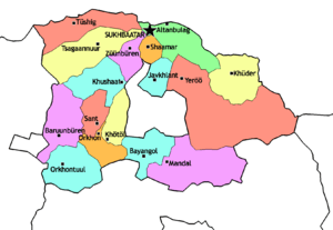
Administrative subdivisions

Sums of Selenge
| Sum | Mongolian | Population (2000) |
Population (2002) |
Population (2004) |
Population (2006) |
Population (2008) |
Area (km²)[2] | Density (/km²) |
|---|---|---|---|---|---|---|---|---|
| Altanbulag | Алтанбулаг | 3,489 | 4,003 | 3,783 | 4,255 | 4,545 | 2100.30 | 2.16 |
| Baruunbüren | Баруунбүрэн | 2,939 | 2,430 | 2,430 | 2,378 | 2,702 | 2814.54 | 0.96 |
| Bayangol | Баянгол | 5,391 | 5,015 | 4,264 | 4,512 | 5,028 | 1976.28 | 2.54 |
| Javkhlant | Жавхлант | 1,767 | 1,921 | 1,838 | 1,704 | 1,827 | 1189.70 | 1.54 |
| Khüder | Хүдэр | 1,799 | 1,772 | 1,838 | 1,936 | 2,078 | 2838.65 | 0.73 |
| Khushaat | Хушаат | 1,406 | 1,679 | 1,946 | 1,654 | 1,585 | 2010.15 | 0.79 |
| Mandal | Мандал | 23,964 | 22,645 | 22,864 | 22,975 | 23,646 | 4843.73 | 4.88 |
| Orkhon | Орхон | 2,817 | 2,467 | 2,106 | 2,006 | 2,165 | 1306.27 | 1.66 |
| Orkhontuul | Орхонтуул | 3,760 | 4,016 | 3,398 | 3,248 | 2,952 | 2940.83 | 1.00 |
| Sant | Сант | 2,062 | 2,050 | 2,033 | 2,054 | 2,056 | 1387.06 | 1.48 |
| Saikhan | Сайхан | 8,737 | 8,795 | 8,282 | 8,100 | 8,285 | 1311.87 | 6.32 |
| Shaamar | Шаамар | 4,809 | 4,157 | 3,783 | 3,944 | 4,158 | 671.91 | 6.19 |
| Sükhbaatar* | Сүхбаатар | 22,374 | 21,076 | 20,025 | 19,916 | 19,626 | 45.35 | 432.77 |
| Tsagaannuur | Цагааннуур | 4,153 | 4,221 | 3,919 | 4,005 | 4,257 | 3814.72 | 1.12 |
| Tüshig | Түшиг | 1,899 | 1,725 | 1,608 | 1,552 | 1,420 | 2492.82 | 0.57 |
| Yeröö | Ерөө | 6,077 | 5,677 | 5,531 | 5,630 | 5,792 | 8203.51 | 0.71 |
| Züünbüren | Зүүнбүрэн | 2,507 | 2,226 | 2,373 | 2,201 | 2,468 | 1204.94 | 2.05 |
* The aimag capital
References
| Wikimedia Commons has media related to Selenge Aimag. |
- ↑ Selenge Aimag Statistical Office. Selenge Aimag Sums Review 2000-2008 Archived July 22, 2011, at the Wayback Machine.
- ↑ Official site of the Selenge aimag Archived November 18, 2007, at the Wayback Machine.
 |
|
 | ||
| |
|
| ||
| ||||
| | ||||
| |
|
This article is issued from Wikipedia - version of the 11/18/2016. The text is available under the Creative Commons Attribution/Share Alike but additional terms may apply for the media files.

