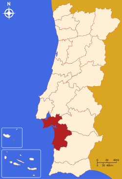
Setúbal District
| District of Setúbal | |
|---|---|
| District | |
 | |
| Country | Portugal |
| Region |
Lisbon and Alentejo |
| Historical province |
Estremadura and Baixo Alentejo |
| No. of municipalities | 13 |
| No. of parishes | 82 |
| Capital | Setúbal |
| Area | |
| • Total | 5,064 km2 (1,955 sq mi) |
| Population | |
| • Total | 788,459 |
| • Density | 160/km2 (400/sq mi) |
| No. of parliamentary representatives | 17 |
The District of Setúbal (Portuguese pronunciation: [sɨˈtuβaɫ] or [sɨˈtuβɐɫ], Portuguese: Distrito de Setúbal) is located in the south-west of Portugal, the District Capital is the city of Setúbal.
Geography
It is delimited by Lisbon District and Santarém District on the north, Évora District on the east, Beja District on the south and the Atlantic Ocean on the west. It has an area of 5064 km², and a population of 789,459 inhabitants. It was split from Lisbon District in 1926, being the only Portuguese district created after 1835.
Municipalities
It is composed of 13 municipalities, spread over two sub regions:
Summary of votes and seats won 1976-2011
Summary of election results from Setúbal district, 1976-2011
| Parties | % | S | % | S | % | S | % | S | % | S | % | S | % | S | % | S | % | S | % | S | % | S | % | S | % | S |
|---|---|---|---|---|---|---|---|---|---|---|---|---|---|---|---|---|---|---|---|---|---|---|---|---|---|---|
| 1976 | 1979 | 1980 | 1983 | 1985 | 1987 | 1991 | 1995 | 1999 | 2002 | 2005 | 2009 | 2011 | ||||||||||||||
| PS | 32.2 | 7 | 21.4 | 4 | 23.5 | 4 | 30.6 | 3 | 16.5 | 3 | 17.6 | 3 | 28.4 | 5 | 44.9 | 9 | 43.7 | 8 | 39.3 | 7 | 43.6 | 8 | 34.0 | 7 | 26.9 | 5 |
| PSD | 8.4 | 1 | 12.7 | 2 | 15.4 | 3 | 32.6 | 6 | 34.7 | 6 | 18.4 | 3 | 18.0 | 3 | 24.7 | 5 | 16.1 | 3 | 16.4 | 3 | 25.2 | 5 | ||||
| CDS-PP | 4.4 | 5.1 | 1 | 3.8 | 1.9 | 2.7 | 7.2 | 1 | 5.6 | 1 | 6.9 | 1 | 5.1 | 1 | 9.1 | 1 | 12.1 | 2 | ||||||||
| PCP/APU/CDU | 44.4 | 9 | 47.0 | 9 | 44.0 | 9 | 45.8 | 8 | 38.2 | 7 | 32.7 | 7 | 24.9 | 5 | 24.8 | 4 | 24.8 | 5 | 20.5 | 4 | 20.0 | 3 | 20.1 | 4 | 19.6 | 4 |
| BE | 3.5 | 4.6 | 10.3 | 2 | 14.0 | 2 | 7.1 | 1 | ||||||||||||||||||
| AD | 22.3 | 4 | 24.1 | 4 | ||||||||||||||||||||||
| PRD / PNR | 20.4 | 4 | 8.7 | 1 | 0.9 | |||||||||||||||||||||
| Source: Comissão Nacional de Eleições | ||||||||||||||||||||||||||
External links
Coordinates: 38°31′27.5″N 8°53′33.4″W / 38.524306°N 8.892611°W
This article is issued from Wikipedia - version of the 2/3/2016. The text is available under the Creative Commons Attribution/Share Alike but additional terms may apply for the media files.