Great Seto Bridge
| Great Seto Bridge (瀬戸大橋 Seto Ōhashi) | |
|---|---|
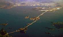 Great Seto Bridge from Honshū (left) via the islands of Hitsuishijima and Yoshima to Shikoku | |
| Coordinates | Coordinates: 34°23′54″N 133°48′36″E / 34.39833°N 133.81000°E |
| Carries |
4 lanes of roadway (upper) 2 rail lines (lower) |
| Crosses | Seto Inland Sea |
| Locale | Honshū and Shikoku |
| Maintained by | Honshu–Shikoku Bridge Authority |
| Characteristics | |
| Design | Double-decked bridge system |
| Total length | 13.1 km (8.1 mi) |
| History | |
| Opened | 1988 |
| Statistics | |
| Toll | 4,850 yen |
The Great Seto Bridge (瀬戸大橋 Seto Ōhashi)[1] is a series of double deck bridges connecting Okayama and Kagawa prefectures in Japan across a series of five small islands in the Seto Inland Sea. Built over the period 1978–88, it is one of the three routes of the Honshū–Shikoku Bridge Project connecting Honshū and Shikoku islands, and the only one with railroad connections included. At 13.1 kilometers (8.1 mi), it ranks as the world's longest two-tiered bridge system.
Crossing the bridge takes about 20 minutes by car or train. The ferry crossing before the bridge was built took about an hour. The non-discounted toll from Kojima, Kurashiki (Okayama Prefecture on the Honshu side) to Sakaide (Kagawa Prefecture on the Shikoku side) is ¥3,500, and vice versa.
The bridges carry two lanes of highway traffic in each direction (Seto-Chūō Expressway) on the upper deck and one railway track in each direction (Seto-Ōhashi Line) on the lower deck. The lower deck was designed to accommodate an additional Shinkansen rail line in each direction.
History
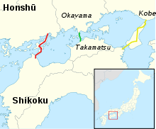
When in 1889 the first railway in Shikoku - between Marugame and Kotohira - was completed, a member of the Prefectural Parliament, Jinnojo Ōkubo (大久保諶之丞 Ōkubo Jinnojo, 1849–1891), stated in his speech at the opening ceremony: "The four provinces of Shikoku are like so many remote islands. If united by roads, they will be much better off, enjoying the benefits of increased transportation and easier communication with each other."
While it took a century for this vision of a bridge across the Seto Inland Sea to become reality, another of Ōkubo's ideas, mentioned in a drinking song he composed, was accomplished twenty years sooner:
- I'll tell you, dear, don't laugh at me,
- a hundred years from now, I'll be seeing you
- flying to and from the moon in a space ship.
- Its port, let me tell you, dear,
- will be that mountaintop over there!
The bridge idea lay dormant for about sixty years. In 1955, after 171 lives were lost when a ferry wrecked in dense fog off the coast of Takamatsu, a safer crossing was deemed necessary. By 1959, meetings were held to promote building the bridge. Scientists began investigations shortly after, and in 1970, the Honshu-Shikoku Bridge Construction Authority was inaugurated. However, work was postponed for five years by the "oil shock" of 1973; once the Environment Assessment Report was published in 1978, construction got underway.
The project took ten years to complete at a cost of US$7 billion; 3.646 million cubic meters (128.8 million cubic feet) of concrete and 705,000 tons of steel were used in construction. Although nets, ropes and other safety measures were employed, the lives of 13 workers were lost during the 10 years of construction. The bridge opened to road and rail traffic on April 10, 1988.
Constituent bridges
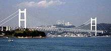
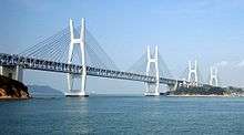
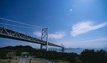
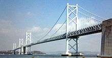
Six of the eleven bridges are separately named, unlike some other long bridge complexes such as the San Francisco–Oakland Bay Bridge. The other five bridges are viaducts. The six named bridges from north to south are listed below.
- Shimotsui-Seto Bridge
- The Shimotsui-Seto Bridge (34°25′51″N 133°48′22.4″E / 34.43083°N 133.806222°E 下津井瀬戸大橋 Shimotsui Seto Ō-hashi) is a double-decked suspension bridge with a center span of 940 meters (3,080 ft) and a total length of 1,400 meters (4,600 ft) which connects Honshū with the island of Hitsuishijima. It is the 22nd largest suspension bridge in the world. It is the northernmost bridge of the Seto-Chuo Expressway.
- Hitsuishijima Bridge
- The Hitsuishijima Bridge (34°24′35″N 133°48′25.6″E / 34.40972°N 133.807111°E 櫃石島橋 Hitsuishijima-kyō) is a double-decked cable-stayed bridge with a center span of 420 meters (1,380 ft) and a total length of 790 meters (2,590 ft). It is immediately north of the identical Iwakurojima Bridge.
- Iwakurojima Bridge
- The Iwakurojima Bridge (34°24′06.3″N 133°48′33″E / 34.401750°N 133.80917°E 岩黒島橋 Iwakurojima-kyō) is a double-decked cable-stayed bridge with a center span of 420 meters (1,380 ft) and a total length of 790 meters (2,590 ft). It is immediately south of the identical Hitsuishijima Bridge.
- Yoshima Bridge
- The Yoshima Bridge (34°23′37.2″N 133°48′45.2″E / 34.393667°N 133.812556°E 与島橋 Yoshima-kyō) is a continuous double-decked truss bridge with a main span of 246 meters (807 ft) and a total of five spans with a length of 847 meters (2,779 ft). It is immediately south of the Hitsuishijima and Iwakurojima Bridges.
- Kita Bisan-Seto Bridge
- The Kita Bisan-Seto Bridge (34°23′43.5″N 133°49′13.7″E / 34.395417°N 133.820472°E 北備讃瀬戸大橋 Kita Bisan Seto Ō-hashi) is a double-decked suspension bridge with two sections linked by a common anchorage between them. The center span is 990 meters (3,248 ft) and the total length is 1,538 m (5,046 ft). It is the 19th largest suspension bridge in the world. The nearly identical Minami Bisan Seto Bridge is located immediately to the south.
- Minami Bisan-Seto Bridge
- The Minami Bisan-Seto Bridge (34°21′51″N 133°49′31″E / 34.36417°N 133.82528°E 南備讃瀬戸大橋 Minami Bisan Seto Ōhashi) is a double-decked suspension bridge with a center span of 1,100 meters (3,609 ft) and a total length of 1,648 m (5,407 ft). It is the 13th longest suspension bridge span in the world. It is the southernmost part of the Great Seto Bridge. The roadway of the bridge is 93 meters (305 ft) above sea level.
Sister bridges
- Golden Gate Bridge, San Francisco, California, United States
- Affiliated from April 5, 1988
- Fatih Sultan Mehmet Bridge, Istanbul, Turkey
- Affiliated from July 3, 1988
- Øresund Bridge, Malmo, Sweden and Copenhagen, Denmark
- Affiliated from May 24, 2008[2]
See also
- Honshū–Shikoku Bridge Project
- List of largest suspension bridges
- List of largest cable-stayed bridges
- Akashi Kaikyō Bridge
- Kurushima-Kaikyō Bridge
References
- ↑ "Seto-Ohashi" is the term used on e.g. Google Maps
- ↑ 2008 Press Release (2008年プレスリリース (Japanese)). JB本四高速 (Honshu-Shikoku Bridge Expressway Company). Accessed February 24, 2010.
External links
| Wikimedia Commons has media related to Great Seto Bridge. |