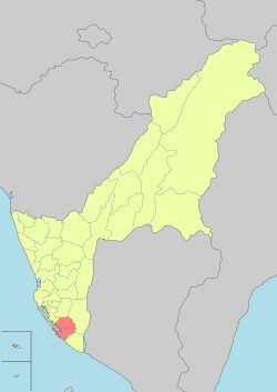
Siaogang District
| Xiaogang 小港區 | |
|---|---|
| District | |
| Xiaogang District [1] | |
|
| |
|
Nickname(s): Port Edge 港仔墘 (pinyin: Gǎngzaǐqián) | |
 | |
| Coordinates: 22°33′16″N 120°21′37″E / 22.554416°N 120.360176°ECoordinates: 22°33′16″N 120°21′37″E / 22.554416°N 120.360176°E | |
| Country | Taiwan |
| Region | Southern Taiwan |
| City | Kaohsiung City |
| Subdivisions |
List
|
| Area | |
| • Total | 45.4426 km2 (17.5455 sq mi) |
| Population (January 2016) | |
| • Total | 156,220 |
| • Density | 3,400/km2 (8,900/sq mi) |
| Website | Official website |
Xiaogang District (Chinese: 小港區; pinyin: Xiǎogāng Qū; Wade–Giles: Hsiao3-kang1 Ch'ü1; Pe̍h-ōe-jī: Sió-káng-khu) is the southernmost district of Kaohsiung City in southern Taiwan. The second largest airport in Taiwan, Kaohsiung International Airport, is located here.
History
Xiaogang was developed during Dutch era. The Dutch built Ang mo Harbor as an addition to Anping Harbor in Tainan. After losing the war against Koxinga, the Dutch left Taiwan. Koxinga's government developed Taiwan as the base to revive the Ming Dynasty and prepare his troops for fighting the Qing dynasty. He sent one of his men, Wu Yanshang, to expand Xiaogang. After Koxinga, his son, and his grandson died, the Qing quickly defeated the Ming remnants and annexed Taiwan.
In 1895, the Qing dynasty ceded Taiwan to Japan in the Treaty of Shimonoseki after losing the First Sino-Japanese War, and Xiaogang was used to produce sugar for Japanese. In 1920, the original name of Kang-a-ki (Chinese: 港仔墘; Pe̍h-ōe-jī: Káng-á-kîⁿ) was changed, and the incorporated areas were administered as Kominato Village (小港庄) under Hōzan District, Takao Prefecture.
As a heavy industry base in Taiwan during World War II, Xiaogang was more heavily bombed by the Allied force than other parts of the city. After the war, Xiaogang was administrated as Xiaogang Township of Kaohsiung County, a third-level government of the Republic of China, under Taiwan Province. Xiaogang was annexed by Kaohsiung City and become Xiaogang District on 1 July 1979, when Kaohsiung City became a special municipality.
Geography
Xiaogang is located in the southern part of Kaohsiung. It borders Qianzhen District to the north, Daliao Township to the east, Linyuan Township to the south, and the Taiwan Strait to the west.
Economy
As far as the industry of Taiwan is concerned, Xiaogang is one of the most important regions for the shipbuilding and steel industries. During the 1970s, the government spent 5 years carrying out Ten Major Construction Projects. Two companies resulting from the projects are based here: China Steel and CSBC Corporation, Taiwan. CPC Corporation, Taiwan also a part of the ten projects, has a major oil refinery facility located here. With the proximity of Kaohsiung Harbor, the products of these companies are exported worldwide. These products are also transported throughout the island via National Highway No. 1 (Taiwan), which terminates on the northern border of the district.
Education
Elementary Schools
- Kaohsiung Municipal Siaogang Elementary School
- Kaohsiung Municipal Taipin Elementary School
- Kaohsiung Municipal Qingshan Elementary School
- Kaohsiung Municipal Pingding Elementary School
- Kaohsiung Municipal Fenglin Elementary School
- Kaohsiung Municipal Huashan Elementary School
- Kaohsiung Municipal Fengyang Elementary School
- Kaohsiung Municipal Huashan Elementary School
- Kaohsiung Municipal Ganghe Elementary School
- Kaohsiung Municipal Mingyi Elementary School
- Kaohsiung Municipal Erling Elementary School
- Kaohsiung Municipal Guilin Elementary School
- Kaohsiung Municipal Hanmin Elementary School
- Kaohsiung Municipal Fengming Elementary School
Junior High Schools
- Kaohsiung Municipal Siaogang Junior High School
- Kaohsiung Municipal Zhongshan Junior High School
- Kaohsiung Municipal Mingyi Junior High School
- Kaohsiung Municipal Fenglin Junior High School
- Kahosiung Municipal Hospitality Junior High School
Senior High Schools
- Kaohsiung Municipal Siaogang Senior High School
- Kao-Fong Vocational Senior high school
Universities
Tourist attractions
- Dapingding Tropical Botanical Garden
- Fonglin Temple
- Fongyi Temple
- Fude Shrine
- Hongmaogang Cultural Park
- Kaohsiung Astronomical Museum
- Kaohsiung Municipal Social Education Hall
- Kaohsiung Park
- Kaohsiung Tropical Plant Garden
- Kao Tower. The name comes from its shape: it is built in the shape of Chinese character "高" (pronounced "Gao", meaning high, tall). It was once a lighthouse. After the building of second harbor of Kaohsiung, it was renewed and became a tourist attraction. The shape of the building is not only a Chinese character but also represent the spirit of Kaohsiung.
Infrastructure
Transportation
Air
The Kaohsiung International Airport is located within the district
Railway
The district is accessible by Kaohsiung International Airport Station and Siaogang Station of the Kaohsiung Mass Rapid Transit.
Road
- Kaohsiung City Bus (Siaogang station)
- Sun-Yat sen Freeway
See also
References
- ↑ "Glossary of Names for Admin Divisions" (PDF). placesearch.moi.gov.tw. Ministry of Interior of the ROC. Retrieved 12 June 2015.
External links
| Wikimedia Commons has media related to Siaogang District, Kaohsiung. |
.svg.png)
