Skellyville, Kansas
| Skellyville, Kansas | |
|---|---|
| Unincorporated community | |
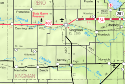 KDOT map of Kingman County (legend) | |
 Skellyville | |
| Coordinates: 37°40′30″N 98°27′1″W / 37.67500°N 98.45028°WCoordinates: 37°40′30″N 98°27′1″W / 37.67500°N 98.45028°W[1] | |
| Country | United States |
| State | Kansas |
| County | Kingman |
| Township | Dresden |
| Elevation[1] | 1,699 ft (518 m) |
| Time zone | CST (UTC-6) |
| • Summer (DST) | CDT (UTC-5) |
| Area code | 620 |
| FIPS code | 20-65750 [1] |
| GNIS ID | 484662 [1] |
Skellyville is an unincorporated community in Kingman County, Kansas, United States.[1] It is located approximately 2 miles (3.2 km) northwest of Cunningham on the north side of the South Fork Ninnescah River.
History
Skellyville was formed when oil was discovered in the area. As the pocket of oil dried up, the population decreased as well. As of 2016, the total population of Skellyville is a few people.
References
External links
Municipalities and communities of Kingman County, Kansas, United States | ||
|---|---|---|
| Cities | 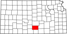 | |
| Unincorporated communities |
| |
| Townships | ||
This article is issued from Wikipedia - version of the 6/19/2016. The text is available under the Creative Commons Attribution/Share Alike but additional terms may apply for the media files.