Sorrento, Western Australia
| Sorrento Perth, Western Australia | |||||||||||||
|---|---|---|---|---|---|---|---|---|---|---|---|---|---|
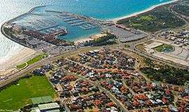
 Sorrento and Hillarys from the air | |||||||||||||
 Sorrento | |||||||||||||
| Coordinates | 31°49′37″S 115°45′14″E / 31.827°S 115.754°ECoordinates: 31°49′37″S 115°45′14″E / 31.827°S 115.754°E | ||||||||||||
| Population | 7,371 (2011 census)[1] | ||||||||||||
| • Density | 2,106/km2 (5,450/sq mi) | ||||||||||||
| Established | 1971 | ||||||||||||
| Postcode(s) | 6020 | ||||||||||||
| Area | 3.5 km2 (1.4 sq mi) | ||||||||||||
| Location | 19 km (12 mi) NW of Perth CBD | ||||||||||||
| LGA(s) | City of Joondalup | ||||||||||||
| State electorate(s) | Hillarys | ||||||||||||
| Federal Division(s) | Moore | ||||||||||||
| |||||||||||||
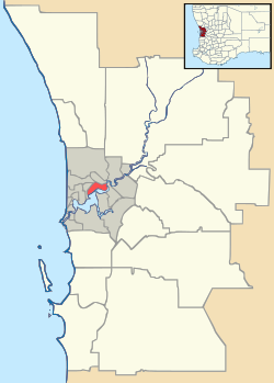
Sorrento is a northern coastal suburb of Perth, the capital city of Western Australia in the local government area of the City of Joondalup. At its northwestern corner is the Hillarys Boat Harbour, built in the late 1980s.
History

A private subdivision of freehold land known as 'Sorrento' was surveyed here in 1929. It is assumed that the name was taken from the Italian seaside town of Sorrento which is located south of Naples opposite the Isle of Capri.[2] Prior to white settlement, the Whadjuk Aboriginal people, who called the area Mooro, gathered abalone and other shellfish in large numbers off the nearby reefs.
The first European to settle in the area was Patrick Marmion, master whaler, who operated a whaling station in the area in 1849. There are still some remains of the old whaling station at the present-day Surf Lifesaving Club site, and a monument to Marmion can be found in Geneff Park in Padbury Circle.
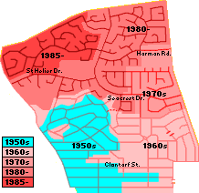
The area was popular with fishermen in the 1930s, and numerous boatsheds and shacks were built there. Residential settlement commenced in the early 1950s and until 1981, it was part of the suburb of Marmion.

In 1958, the Sisters of Our Lady of the Missions bought land in Sorrento at what was then the end of the West Coast Highway, and in 1967, the Sisters and boarding students moved from Highgate to the new site, Sacred Heart College Sorrento. The college became coeducational in 1977, and in 1989, the Catholic Education Commission took over management of the school.[3]
In preparation for Australia's defence of the 1987 America's Cup at Fremantle, the State Government commissioned the building of Hillarys Boat Harbour, the first major marina in the north metropolitan area. The retail complex on the site, called Sorrento Quay, commenced trading in December 1987 and was officially opened in January 1988. Also, in May 1987, the Government declared Marmion Marine Park over a region from Burns Beach to Trigg, to which the new marina complex provided a gateway.[4][5]
Geography
Sorrento is bounded by Hepburn Avenue to the north, Marmion Avenue to the east, Marine Terrace to the south and West Coast Drive and the Indian Ocean to the west.[6]
At the ABS 2001 census, Sorrento had a population of 7,321 people living in 2,796 dwellings. Sorrento's oceanside location and to Hillarys Boat Harbour has seen the suburb become affluent since the 1980s, and the ABS identified many managers and professionals living within the suburb. However, many tradespeople and service employees also live in the area.[7]
Facilities
Sorrento is a residential suburb, relying on the Seacrest Village shopping centre for basic commercial services, and Whitford City and Centro Warwick for other services. Several parks of various sizes are situated in the suburb.[6]
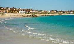
The Sorrento Quay retail development within the Hillarys Boat Harbour sits on the northwestern boundary of the suburb. Off the coast is the Marmion Marine Park,[5] which provides a home for many species of marine animals.
Education
Sorrento contains a Catholic private school, Sacred Heart College, and a state primary school, Sorrento Primary School (founded 1970). The suburb falls within Duncraig Senior High School's catchment area.
Transport
Sorrento is served by the 423 and 441 buses from Warwick railway station and Whitfords Train Station,[8] operated by the Swan Transit.
Politics
Sorrento is a reasonably affluent suburb with many "mortgage belt" families. The beachside part of Sorrento, together with Hillarys to its north, is the strongest base in the northern suburban region for the Liberal Party at both federal and state elections.
See also
References
- ↑ Australian Bureau of Statistics (31 October 2012). "State Suburbs: Sorrento". 2011 Census QuickStats. Retrieved 4 July 2012.
- ↑ Western Australian Land Information Authority. "History of metropolitan suburb names – S". Retrieved 2007-01-17.
- ↑ Sacred Heart - History, accessed 2007-01-17
- ↑ Department for Planning and Infrastructure (WA). "Hillarys Boat Harbour". Retrieved 2007-01-17.
- 1 2 Conservation and Land Management (December 2000). "Marmion Marine Park". Retrieved 2007-01-17.
- 1 2 Department of Land Information. StreetSmart® Perth Street Directory (54 (2013) ed.). West Australian Newspapers Ltd. pp. Map 280. ISBN 978-0-909439-67-5.
- ↑ Australian Bureau of Statistics (19 November 2002). "Community Profile Series : Sorrento (State Suburb)". 2001 Census of Population and Housing. Retrieved 2007-06-22.
- ↑ Bus Timetable 62, Transperth, effective 31 January 2016; Bus Timetable 63, Transperth, effective 31 January 2016. Accessed 12 January 2016.