South Dakota Highway 377
| ||||
|---|---|---|---|---|
|
Location of SD 377 (in red) | ||||
| Route information | ||||
| Defined by SDCL §31-4-234 | ||||
| Maintained by SDDOT | ||||
| Length: | 2.173 mi[1] (3.497 km) | |||
| Major junctions | ||||
| South end: |
| |||
| North end: |
| |||
| Location | ||||
| Counties: | Jackson | |||
| Highway system | ||||
| ||||

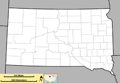
South Dakota Highway 377 (SD 377) is a 2-mile-long (3.2 km) state route that runs entirely within Jackson County, South Dakota. It begins at its intersection with SD 44 in Interior, and runs in a northeasterly direction to its northern terminus at its intersection with SD 240 in the Badlands National Park.
Route description
Southern terminus
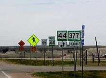
SD 377 begins at an intersection with SD 44 in northeastern Interior. It is a near-straight two-lane highway for its entire length. It enters Badlands National Park and ends at SD 240 near the park's headquarters.
Major intersections
The entire route is in Jackson County.
| Location | mi[1] | km | Destinations | Notes | |
|---|---|---|---|---|---|
| Interior | 0.000 | 0.000 | |||
| Badlands National Park | 2.173 | 3.497 | |||
| 1.000 mi = 1.609 km; 1.000 km = 0.621 mi | |||||
References
- 1 2 "Transportation Inventory Management". South Dakota Department of Transportation. Retrieved October 3, 2011.
External links
This article is issued from Wikipedia - version of the 9/23/2013. The text is available under the Creative Commons Attribution/Share Alike but additional terms may apply for the media files.
