Springfield Terminal railroad bridge, Deerfield
| Springfield Terminal railroad bridge | |
|---|---|
 | |
| Coordinates | 42°33′44″N 72°33′22″W / 42.56222°N 72.55611°WCoordinates: 42°33′44″N 72°33′22″W / 42.56222°N 72.55611°W |
| Carries | Springfield Terminal Railway |
| Crosses | Connecticut River |
| Locale | Deerfield and Montague, Franklin County, Massachusetts |
| Maintained by | Pan Am Railways |
| Characteristics | |
| Design | Deck truss bridge |
| Material | Cast or Wrought Iron, on masonry piers |
| Number of spans | 3 |
| Piers in water | 2 |
 Springfield Terminal railroad bridge Location in Massachusetts | |
The Springfield Terminal railroad bridge in Deerfield, Massachusetts, is a three-span deck-truss bridge which crosses the Connecticut River.
History
The railroad crossing at this location dates to 1850 when a branch of the Fitchburg Railroad opened from Grout's Corner west to Greenfield. This line would later connect to the Hoosac Tunnel, which opened to rail traffic in 1875.
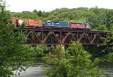
Pan Am Railways train MOAY on the bridge 7/1/10
The bridge carries rail traffic in and out of the former Boston & Maine Railroad yard at East Deerfield. The bridge, owned by Pan Am Railways, is at the east end of the yard.
See also
Notes
^ B: United States Geological Survey topographic map showing the bridge as the Fitchburg Railroad bridge.[1]
References
- ↑ "USGS 15 minute Greenfield, Massachusetts topographic map (South-East corner)" (JPEG). University of New Hampshire. 1886-1887, reprinted 1918. Retrieved 2008-07-29. Check date values in:
|date=(help)
General references
- USGS Greenfield, Massachusetts Quadrangle Map, September 1894, reprinted 1918. Historic USGS Maps of New England & New York, University of New Hampshire Library Digital Collections Initiative.
- Howes, Marc (2005). "The History of the Hoosac Tunnel". Retrieved 2008-07-20.
- Massachusetts Historical Commission, Massachusetts Secretary of the Commonwealth (1982). MHC Reconnaissance Survey Town Report, Montague (PDF). Boston: Commonwealth of Massachusetts. pp. 12–13.
| Crossings of the Connecticut River | ||||
|---|---|---|---|---|
| ||||
This article is issued from Wikipedia - version of the 9/21/2016. The text is available under the Creative Commons Attribution/Share Alike but additional terms may apply for the media files.