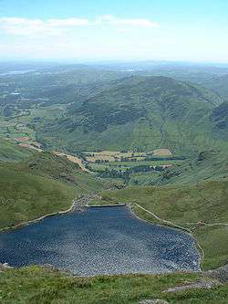
Stickle Tarn, Langdale
| Stickle Tarn | |
|---|---|
 Stickle Tarn from above | |
| Location | England |
| Coordinates | 54°27′31″N 3°6′9″W / 54.45861°N 3.10250°WCoordinates: 54°27′31″N 3°6′9″W / 54.45861°N 3.10250°W |
| Type | tarn (lake) |
| Basin countries | United Kingdom |
| Max. depth | 50 ft (15 m) |
Stickle Tarn is a small tarn near Harrison Stickle in Lake District, England.The tarn was enlarged by the building of a stone dam in 1838 and is used to supply water for the inhabitants of Langdale.
In February 2015 it was put up for sale by the Lake District National Park Authority, which was seeking to reduce its landholdings in the national park.[1]
References
- ↑ Lake District's Stickle Tarn among seven areas for sale. BBC News Cumbria. Retrieved 2015-02-10.
This article is issued from Wikipedia - version of the 2/23/2015. The text is available under the Creative Commons Attribution/Share Alike but additional terms may apply for the media files.
