Texas State Highway 137
| |||||||
|---|---|---|---|---|---|---|---|
 | |||||||
| Route information | |||||||
| Maintained by TxDOT | |||||||
| Length: | 192.24 mi[1] (309.38 km) | ||||||
| Existed: | by 1931 – present | ||||||
| Major junctions | |||||||
| South end: |
 SH 163 near Ozona SH 163 near Ozona | ||||||
 US 190 US 190 I-20 in Stanton I-20 in Stanton  US 62 / US 385 in Brownfield US 62 / US 385 in Brownfield  US 82 / US 380 in Brownfield US 82 / US 380 in Brownfield | |||||||
| North end: |
US 385 near Brownfield | ||||||
| Highway system | |||||||
| |||||||


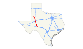
Texas State Highway 137 or SH 137 is a highway that runs from Brownfield to near Ozona in west Texas. This route was designated by 1939 on a route from Brownfield south through Midland and Rankin, ending west of Sheffield. By 1942, everything south of Lamesa was either cancelled, transferred to FM 9, or transferred to SH 51. It was exnteded south to Stanton in 1943, replacing State Highway 303.[2] In 1984, the route was extended 109 miles (175 km) south to its current southern terminus, when it replaced all or portions of RM 33, RM 865, and RM 1800.
Previous routes
SH 137 was previously designed by 1931 along a different west Texas route between Lubbock and McCamey. The portion from Lubbock to Brownfield, which was designated as SH 53, was renumbered as SH 137. By 1935, the route south of Brownfield had become SH 51. By 1939, this route had been reassigned to U.S. Highway 62.
Junction list
| County | Location | mi | km | Destinations | Notes |
|---|---|---|---|---|---|
| Crockett | | SH 163 – Barnhart, Ozona | |||
| |  RM 1964 west RM 1964 west | ||||
| | US 190 east – Eldorado | South end of US 190 overlap | |||
| | US 190 west – Iraan | North end of US 190 overlap | |||
| Reagan | Big Lake |  US 67 – Rankin, San Angelo US 67 – Rankin, San Angelo | |||
| |  RM 33 north – Big Spring RM 33 north – Big Spring | ||||
| |  RM 1357 – Midland RM 1357 – Midland | ||||
| Glasscock | |  RM 2401 – Midkiff RM 2401 – Midkiff | |||
| |  SH 158 – Midland, Garden City SH 158 – Midland, Garden City | ||||
| Midland | |  FM 307 – Midland FM 307 – Midland | |||
| Martin | Stanton |  BL I-20 – Midland, Big Spring BL I-20 – Midland, Big Spring | |||
| I-20 – El Paso, Abilene | I-20 exit 156 | ||||
| |  SH 176 – Andrews, Big Spring SH 176 – Andrews, Big Spring | ||||
| |  FM 846 east – Knott FM 846 east – Knott | ||||
| |  FM 2002 east – Ackerly FM 2002 east – Ackerly | South end of FM 2002 overlap | |||
| | FM 2002 west | North end of FM 2002 overlap | |||
| Dawson | |  FM 828 – Patricia FM 828 – Patricia | |||
| |  FM 2052 west FM 2052 west | ||||
| |  SH 349 south – Midland SH 349 south – Midland | ||||
| Lamesa |  US 180 – Seminole, Gail US 180 – Seminole, Gail | ||||
  FM 2592 east to US 87 FM 2592 east to US 87 | |||||
| |  FM 1064 west FM 1064 west | ||||
| |  FM 1066 west FM 1066 west | ||||
| Welch |  SH 83 west – Seagraves SH 83 west – Seagraves | ||||
 FM 829 south FM 829 south | |||||
| Terry | |  FM 213 FM 213 | |||
| |  FM 1076 east FM 1076 east | ||||
| Brownfield | US 62 east / US 385 north – Lubbock | South end of US 62/385 overlap | |||
 US 62 west / US 385 south / FM 403 south – Seminole US 62 west / US 385 south / FM 403 south – Seminole | North end of US 62/385 overlap | ||||
| US 82 / US 380 – Plains, Tahoka | |||||
| | US 385 – Levelland, Brownfield | ||||
1.000 mi = 1.609 km; 1.000 km = 0.621 mi
| |||||
References
- ↑ Texas Department of Transportation SH 137,
- ↑ Texas Department of Transportation SH 303,