Texas State Highway Loop 9

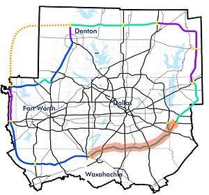
Loop 9 is a proposed state highway that will be located on the southern fringes of the Dallas/Fort Worth Metroplex along the southern Dallas County line westward into northern Johnson County. It will measure about 45 miles (72 km) in length. Although it can be considered the southern counterpart to the President George Bush Turnpike (PGBT), it is actually being re-integrated into a plan for a broad outer loop that would extend far north of the metroplex. Loop 9 and the outer loop are part of a long-term plan to serve the growing, expanding DFW population, forecast to rise past 10 million by 2040.[1]
The alignment of Loop 9 is still under study by a task force under the direction of county governments. The route is expected to start somewhere in southern Mesquite, Texas at an interchange with Interstate 20 where it may connect with either the PGBT or a proposed Rockwall/Kaufman County Outer Loop. It will run from that point southwest to Interstate 45 in Ferris, to Interstate 35E in Glenn Heights, just north of Red Oak. It will continue west through Ovilla and U.S. Highway 67 in Cedar Hill, intersecting at U.S. Highway 287 near Mansfield. It would terminate near the Chisholm Trail Parkway southwest of Fort Worth. By 2030, planning authorities expect Loop 9 to serve as part of a large outer loop encircling the metroplex.
The corridor was first identified in 1968 and a preliminary study completed in 1995. A final decision on the route was projected to be made by 2009, but remains undecided. No funding has been set aside for what is likely to become a US$500 million to $1 billion project. The Draft Environmental Impact Statement (DEIS) originally expected to be completed in 2009 was also not completed as of 2012, and TxDOT estimates of a 2015 opening have passed. The proposed road has been affected by a national recession, a construction slowdown, and a severe shortage of state highway funds [2] and may remain in the planning stages for many years.
Connection With Other Highways
The loop will hit I-35E in the 2020s.
References
- ↑ 2040 Demographic Forecast. North Central Texas Council of Governments, Research & Information Services, 2011.
- ↑ Texas highway funding crisis: Are we there yet?, Gary Scharrer, Houston Chronicle, 2011-01-30, accessed 2012-02-21.
External links
- Loop 9 - official project page
- Salcedo Group - Loop 9 study (Dallas County maps)
- North Texas Council of Governments maps