The Plains, Ohio
| The Plains, Ohio | |
|---|---|
| Census-designated place | |
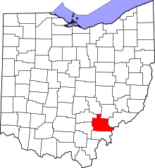
 Location of The Plains, Ohio | |
| Coordinates: 39°22′13″N 82°7′56″W / 39.37028°N 82.13222°WCoordinates: 39°22′13″N 82°7′56″W / 39.37028°N 82.13222°W | |
| Country | United States |
| State | Ohio |
| County | Athens |
| Area | |
| • Total | 2.3 sq mi (5.9 km2) |
| • Land | 2.3 sq mi (5.9 km2) |
| • Water | 0.0 sq mi (0.0 km2) |
| Elevation[1] | 715 ft (218 m) |
| Population (2010) | |
| • Total | 3,080 |
| • Density | 1,352/sq mi (522.2/km2) |
| Time zone | Eastern (EST) (UTC-5) |
| • Summer (DST) | EDT (UTC-4) |
| ZIP code | 45780 |
| Area code(s) | 740 |
| FIPS code | 39-76568[2] |
| GNIS feature ID | 1077041[1] |
The Plains is a census-designated place (CDP) in Athens County, Ohio, United States. The population was 3,080 at the 2010 census.[3]
History
"The Plains" originally referred to the local region where the Mound Builders lived and built their signature Indian mounds.[4] A post office called The Plains has been in operation since 1908.[5]
Geography
The Plains is located at 39°22′13″N 82°7′56″W / 39.37028°N 82.13222°W (39.370281, -82.132299).[6]
According to the United States Census Bureau, the CDP has a total area of 2.3 square miles (5.9 km2), of which 0.0077 square miles (0.02 km2), or 0.28%, is water.[3]
Open space
A nature preserve was created in The Plains recently by the Athens Conservancy.[7][8] An extension of the Hockhocking Adena Bikeway is planned to traverse the preserve and provide bikeway access for the community.[9][10]
Demographics
As of the census[2] of 2000, there were 2,931 people, 1,224 households, and 714 families residing in the CDP. The population density was 1,275.8 people per square mile (492.0/km²). There were 1,344 housing units at an average density of 585.0/sq mi (225.6/km²). The racial makeup of the CDP was 94.13% White, 2.42% African American, 0.31% Native American, 1.09% Asian, 0.27% from other races, and 1.77% from two or more races. Hispanic or Latino of any race were 0.82% of the population.
There were 1,224 households out of which 29.0% had children under the age of 18 living with them, 41.0% were married couples living together, 14.0% had a female householder with no husband present, and 41.6% were non-families. 33.9% of all households were made up of individuals and 11.6% had someone living alone who was 65 years of age or older. The average household size was 2.24 and the average family size was 2.88.
In the CDP the population was spread out with 23.5% under the age of 18, 10.4% from 18 to 24, 28.1% from 25 to 44, 19.4% from 45 to 64, and 18.5% who were 65 years of age or older. The median age was 36 years. For every 100 females there were 80.0 males. For every 100 females age 18 and over, there were 72.5 males.
The median income for a household in the CDP was $30,102, and the median income for a family was $44,761. Males had a median income of $26,687 versus $25,106 for females. The per capita income for the CDP was $17,164. About 13.3% of families and 17.7% of the population were below the poverty line, including 18.9% of those under age 18 and 14.8% of those age 65 or over.
Arts and culture
The Plains is known for its history of Native American burial mounds and ceremonial circles. Nearly 25 mounds were identified here, and the complex has been listed on the National Register of Historic Places. These are collectively known as the Wolf Plains Mound Group. The Archaeological Conservancy has been buying the sites of the mounds to protect them from development.
Education
Public schools
The residents of The Plains are served by the Athens City School District and Athens High School.
Public libraries
The Plains is served by the Athens County Public Libraries with branches in Albany, Athens, Chauncey, Coolville, Glouster, Nelsonville, and The Plains.[11]
References
- 1 2 "US Board on Geographic Names". United States Geological Survey. 2007-10-25. Retrieved 2008-01-31.
- 1 2 "American FactFinder". United States Census Bureau. Retrieved 2008-01-31.
- 1 2 "Geographic Identifiers: 2010 Demographic Profile Data (G001): The Plains CDP, Ohio". U.S. Census Bureau, American Factfinder. Retrieved July 10, 2013.
- ↑ Martzolff, Clement Luther (1916). A Brief History of Athens County, Ohio. The author. p. 7.
- ↑ "Athens County". Jim Forte Postal History. Retrieved 31 December 2015.
- ↑ "US Gazetteer files: 2010, 2000, and 1990". United States Census Bureau. 2011-02-12. Retrieved 2011-04-23.
- ↑ "Conservancy Creates New Preserve in The Plains, Will Connect to Bike Path". Retrieved 2011-03-05.
- ↑ "The Plains nature preserve grows by 8 acres". Retrieved 2011-03-05.
- ↑ "New Spur to Extend Bikeway". Retrieved 2011-03-06.
- ↑ "Bike Path Spur Gets Green Light". Retrieved 2011-03-06.
- ↑ "Athens County Library Branches". Retrieved 2011-03-06.
