Tuen Mun Station
| MTR rapid transit station | |||||||||||
|
Tuen Mun Station platform | |||||||||||
| Chinese name | |||||||||||
| Traditional Chinese | 屯門 | ||||||||||
| Simplified Chinese | 屯门 | ||||||||||
| |||||||||||
| General information | |||||||||||
| Location |
Pui To Road × Tuen Mun River, Tuen Mun Tuen Mun District, Hong Kong | ||||||||||
| Coordinates | 22°23′43″N 113°58′23″E / 22.3952°N 113.9731°ECoordinates: 22°23′43″N 113°58′23″E / 22.3952°N 113.9731°E | ||||||||||
| Owned by | KCR Corporation | ||||||||||
| Operated by | MTR Corporation | ||||||||||
| Line(s) | |||||||||||
| Platforms | 2 (1 island platform) | ||||||||||
| Tracks | 2 | ||||||||||
| Connections | |||||||||||
| Construction | |||||||||||
| Structure type | Elevated | ||||||||||
| Disabled access | Yes | ||||||||||
| Other information | |||||||||||
| Station code | TUM | ||||||||||
| History | |||||||||||
| Opened |
| ||||||||||
| Services | |||||||||||
| |||||||||||
| Location | |||||||||||
 Tuen Mun Location within the MTR system | |||||||||||
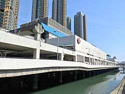
Tuen Mun (Chinese: 屯門) is a MTR station in Tuen Mun, New Territories, Hong Kong. It is the northern terminus of the West Rail Line. The station is elevated over the Tuen Mun River, near the Town Park in the centre of Tuen Mun New Town. The first train to Hung Hom departs at 5:45 a.m., and the last train departs at 12:15 a.m. the day after.
It is an interchange station with the Light Rail Tuen Mun Stop and Ho Tin Stop. A public transport interchange adjacent to the station gives passengers direct access to the station concourse via escalators and stairs.
History
Tuen Mun Station is adjacent to the former site of San Fat Estate, the first public housing estate in Tuen Mun, which was demolished in 2001 because of its age, and to provide a construction site for the station.[1]
There is a plaque in the station concourse commemorating the topping out of the station. It was unveiled by the then-Chairman and Chief Executive of KCR Corporation, K.Y. Yeung, on 14 November 2001.
Station layout
| P Platforms |
Platform 2 | West Rail Line towards Hung Hom (Siu Hong) → |
| Island platform, doors will open on the left or right | ||
| Platform 1 | West Rail Line towards Hung Hom (Siu Hong) → | |
| C | Light Rail Ho Tin Stop |
Exit F, Taxi Stand, drop-off area |
| Concourse | Exit, customer services, toilets | |
| MTRShops, vending machines, ATMs | ||
| Light Rail Tuen Mun Stop |
Exit B, Light Rail Tuen Mun Stop, MTRShops | |
| G | Light Rail Ho Tin Stop |
Light Rail Ho Tin Stop |
| Exit C | Exit C1, C2, public transport interchange | |
| Light Rail Tuen Mun Stop |
Passageway | |


Platforms 1 and 2 share the same island platform. Passengers can catch eastbound West Rail Line trains on either platform.[2]
Entrances/exits
- A: Pui To Road[3]
- B: Light Rail - Tuen Mun
 [3]
[3] - C1: Pui To Road
 [3]
[3] - C2: Public Transport Interchange
 [3]
[3] - D, E: Century Gateway, V City[3]
- F1: Taxi Stand
 [3]
[3] - F2: Light Rail - Ho Tin[3]
Public light bus:[3]
46: Fu Tai to Tuen Mun Town Centre
46A: Noble Hill to Tuen Mun Town Centre
References
- ↑ 「Mixed development」 for the redevelopment of San Fat Estate
- ↑ "Tuen Mun Station layout" (PDF). MTR Corporation. Retrieved 30 October 2016.
- 1 2 3 4 5 6 7 8 "Tuen Mun Station street map" (PDF). MTR Corporation. Retrieved 30 October 2016.
External links
- "San Fat Estate" (in Chinese). HKiTalk.Net. Retrieved 2007-01-14.
| Wikimedia Commons has media related to Tuen Mun Station. |