U.S. Route 19 in Georgia
| ||||
|---|---|---|---|---|
|
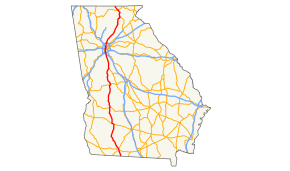
Route of US 19 in Georgia in red | ||||
| Route information | ||||
| Maintained by GDOT | ||||
| Length: | 351 mi[1] (565 km) | |||
| Major junctions | ||||
| South end: |
| |||
|
| ||||
| North end: |
| |||
| Location | ||||
| Counties: | Thomas, Mitchell, Dougherty, Lee, Sumter, Schley, Taylor, Upson, Pike, Spalding, Clayton, Fulton, Forsyth, Dawson, Lumpkin, Union | |||
| Highway system | ||||
| ||||

U.S. Route 19 (US 19) is a U.S. Highway that travels from Memphis, Florida to Erie, Pennsylvania. In the U.S. state of Georgia, it runs 348 miles (560 km) from the Florida state line south of Thomasville, Georgia, through Atlanta, to the North Carolina state line at a point north of Lake Nottely.[1]
Route description
US 19 enters Georgia just south of Thomasville. It continues north, passing through Zebulon, Thomaston, Ellaville, Americus, and Albany. It joins US 41 and proceeds north to Griffin. It then proceeds through the western tip of Henry County, passing through Hampton, home of the Atlanta Motor Speedway. US 19 continues north through Clayton County where it joins SR 3 and is known as Tara Boulevard, before entering Atlanta.
Within Atlanta, US 19/41 is joined by U.S. Route 29 in Georgia and all three passes by the Georgia Dome before a short multiplex with U.S. Routes 78/278 near Georgia Tech.
The road then turns north again and splits from US 41 after passing through downtown Atlanta and traveling on 14th Street. It becomes Spring Street in Midtown before continuing north on Peachtree Street and then SR 9 (Roswell Road). After several miles, it intersects with SR 141 in Buckhead. It follows Roswell Road north through the city of Sandy Springs and leaves Atlanta from the north side of the city. At the interchange with I-285's north side, it splits from SR 9.
Most of this section is a Limited-access road with four lanes in each direction, becoming two lanes in each direction as the highway continues away from the northern suburbs of Atlanta. It arrives in Dahlonega, where it no longer is concurrent with SR 400, before about 37 miles (60 km) of extremely curvy road, which includes an overlap with U.S. Route 129 in Georgia. From the north side of the state, the last town it passes through is Blairsville.
History
In 2006, business and government officials in Columbus began a campaign to have I-185 extended to Monticello, Florida, and connect with Interstate 10. The proposed route would travel parallel with SR 520 (known as Corridor Z) to Albany, and then parallel with US 19.
Major intersections
| County | Location | mi | km | Exit | Destinations | Notes | |
|---|---|---|---|---|---|---|---|
| Thomas | | 0.00 | 0.00 | Florida state line | |||
| Thomasville | 11.3 | 18.2 | Old Monticello Road | former US 19 Bus. north | |||
| 13.0 | 20.9 | interchange; southern end of US 84 / SR 38 concurrency | |||||
| 14.2 | 22.9 | ||||||
| 14.7 | 23.7 | ||||||
| | 15.8 | 25.4 | Northern end of US 84 / SR 38 concurrency | ||||
| | 18.2 | 29.3 | |||||
| Ochlocknee | 24.5 | 39.4 | former US 19 Bus. south | ||||
| | 31.9 | 51.3 | |||||
| Mitchell | Pelham | 37.4 | 60.2 | ||||
| Camilla | 45.5 | 73.2 | south end of SR 37 Truck overlap | ||||
| 45.6 | 73.4 | north end of SR 37 Truck overlap | |||||
| Baconton | 56.3 | 90.6 | |||||
| Dougherty | Albany | 68.2 | 109.8 | 1 | south end of SR 133 overlap | ||
| 70.0 | 112.7 | 2 | signed as exits 2A (east) and 2B (west) | ||||
| 70.6 | 113.6 | 3 | north end of SR 300 overlap; south end of US 82 / SR 520 overlap | ||||
| 71.9 | 115.7 | 4 | Blaylock Street | ||||
| 73.9 | 118.9 | 5 | north end of SR 133 overlap; signed northbound as exits 5A (north) and 5B (south) | ||||
| 75.2 | 121.0 | north end of US 82 / SR 520 overlap; US 19 north follows exit 6A; US 19 Bus. / US 82 Bus. / SR 520 Bus. is exit 6B northbound | |||||
| Lee | | 78.2 | 125.9 | ||||
| Leesburg | 82.5 | 132.8 | Southern end of SR 32 concurrency | ||||
| 83.4 | 134.2 | Northern end of SR 32 concurrency | |||||
| 84.0 | 135.2 | ||||||
| Smithville | 96.0 | 154.5 | |||||
| | 98.1 | 157.9 | |||||
| Sumter | | 108 | 174 | Southern end of US 280 / SR 27 / SR 49 concurrency | |||
| Americus | 109 | 175 | Northern end of US 280 / SR 27 / SR 49 concurrency; southern end of SR 30 concurrency | ||||
| 110 | 180 | Northern end of SR 30 concurrency | |||||
| Schley | | 118 | 190 | ||||
| | 121 | 195 | |||||
| | 121 | 195 | Andersonville Road | former SR 228 west | |||
| Ellaville | 122 | 196 | |||||
| Murrays Crossroads | 128 | 206 | |||||
| Taylor | | 135 | 217 | Southern end of SR 127 / SR 90 concurrency | |||
| | 136 | 219 | Northern end of SR 127 concurrency | ||||
| Rupert | 137 | 220 | Northern end of SR 90 concurrency | ||||
| Butler | 145 | 233 | |||||
| 146 | 235 | ||||||
| | 153 | 246 | |||||
| | 158 | 254 | Southern end of US 80 concurrency | ||||
| Upson | | 160 | 260 | Northern end of US 80 concurrency | |||
| Thomaston | 173 | 278 | |||||
| 174 | 280 | ||||||
| Pike | | 185 | 298 | south end of SR 109 overlap | |||
| | 186 | 299 | north end of SR 109 overlap | ||||
| Zebulon | 190 | 310 | |||||
| Spalding | | 197 | 317 | Southern end of US 41 concurrency | |||
| Griffin | 200 | 320 | Interchange | ||||
| 201 | 323 | Interchange | |||||
| 202 | 325 | Interchange; southbound exit and northbound entrance; south end of SR 92 overlap | |||||
| 203 | 327 | north end of SR 92 overlap | |||||
| Henry | Hampton | 210 | 340 | Interchange | |||
| | 213 | 343 | |||||
| Clayton | Jonesboro | 220 | 350 | south end of SR 54 overlap | |||
| 224 | 360 | ||||||
| | 225 | 362 | north end of SR 54 overlap | ||||
| | 228 | 367 | I-75 exit 235 | ||||
| Forest Park | 231 | 372 | |||||
| 231 | 372 | Southpoint Drive to Main Street | former SR 160 east | ||||
| 232 | 373 | I-285 exit 58 | |||||
| Fulton | Atlanta–Hapeville line | 233 | 375 | I-75 exit 239 | |||
| Atlanta | 236 | 380 | I-85 exit 77 | ||||
| 236 | 380 | interchange | |||||
| 240 | 390 | Southern end of US 29 concurrency | |||||
| 242 | 389 | Southern end of US 78 / US 278 / SR 8 concurrency | |||||
| 242 | 389 | Northern end of US 78 / US 278 / SR 8 concurrency | |||||
| 242 | 389 | Tech Parkway | Interchange; southbound exit and northbound entrance | ||||
| 243 | 391 | Northern end of US 41 / SR 3 concurrency; southern end of SR 9 concurrency | |||||
| 244 | 393 | I-75 exit 250 / I-85 exit 84 | |||||
| 245 | 394 | interchange | |||||
| 248 | 399 | ||||||
| 249 | 401 | ||||||
| Sandy Springs | 253 | 407 | north end of SR 9 overlap; south end of I-285 / SR 407 overlap; US 19 south follows exit 25 | ||||
| 254 | 409 | 26 | Glenridge Drive / Glenridge Connector | northbound exit and southbound entrance; former SR 407 Loop | |||
| 254 | 409 | north end of I-285 / SR 407 overlap; south end of SR 400 overlap; US 19 north follows exit 27; US 19 south follows exit 4B | |||||
| see SR 400 | |||||||
| Lumpkin | | 301 | 484 | north end of SR 400 overlap; south end of SR 60 overlap | |||
| Dahlonega | 306 | 492 | south end of SR 9 / SR 52 overlap | ||||
| 307 | 494 | ||||||
| 307 | 494 | Northern end of SR 52 concurrency | |||||
| | 309 | 497 | |||||
| Porter Springs | 314 | 505 | Northern end of SR 60 concurrency | ||||
| Turners Corner | 319 | 513 | north end of SR 9 overlap; south end of US 129 / SR 11 overlap | ||||
| Union | | 330 | 530 | south end of SR 180 concurrency | |||
| | 332 | 534 | north end of SR 180 concurrency | ||||
| | 339 | 546 | |||||
| Blairsville | 340 | 550 | traffic circle around Old Union County Courthouse | ||||
| 340 | 550 | ||||||
| Ivylog | 349 | 562 | |||||
| | 351 | 565 | North Carolina state line | ||||
1.000 mi = 1.609 km; 1.000 km = 0.621 mi
| |||||||
See also
.svg.png) Georgia (U.S. state) portal
Georgia (U.S. state) portal U.S. Roads portal
References
- 1 2 "Route of US 19 in Georgia". Google. Retrieved 2011-01-30.
External links
-
 Media related to U.S. Route 19 in Georgia at Wikimedia Commons
| Previous state: Florida |
Georgia | Next state: North Carolina |
