Vestine (crater)
|
Oblique Apollo 16 mapping camera image | |
| Coordinates | 33°54′N 93°54′E / 33.9°N 93.9°ECoordinates: 33°54′N 93°54′E / 33.9°N 93.9°E |
|---|---|
| Diameter | 96 km |
| Depth | Unknown |
| Colongitude | 268° at sunrise |
| Eponym | Ernest H. Vestine |
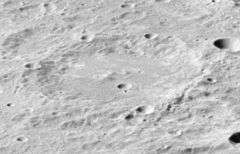
Vestine is a heavily eroded impact crater on the Moon's far side, just beyond the northeastern limb. It lies to the southwest of the large walled plain Harkhebi, and to the northwest of the Maxwell–Richardson crater pair.
The outer rim of this crater is an irregular ridge about the interior floor. The small satellite crater Vestine A lies across the northern rim. The crater Vestine covers the eastern half of the crater Vestine T, an older and somewhat smaller formation. The interior floor has a rounded central ridge with a small craterlet located just to the east.
Prior to formal naming in 1970 by the IAU,[1] this crater was known as Crater 111.[2]
Satellite craters
By convention these features are identified on lunar maps by placing the letter on the side of the crater midpoint that is closest to Vestine.
| Vestine | Latitude | Longitude | Diameter |
|---|---|---|---|
| A | 36.2° N | 94.8° E | 17 km |
| T | 33.9° N | 91.1° E | 49 km |
References
- ↑ Vestine, Gazetteer of Planetary Nomenclature, International Astronomical Union (IAU) Working Group for Planetary System Nomenclature (WGPSN)
- ↑ Lunar Farside Chart (LFC-1A)
- Andersson, L. E.; Whitaker, E. A. (1982). NASA Catalogue of Lunar Nomenclature. NASA RP-1097.
- Blue, Jennifer (July 25, 2007). "Gazetteer of Planetary Nomenclature". USGS. Retrieved 2007-08-05.
- Bussey, B.; Spudis, P. (2004). The Clementine Atlas of the Moon. New York: Cambridge University Press. ISBN 978-0-521-81528-4.
- Cocks, Elijah E.; Cocks, Josiah C. (1995). Who's Who on the Moon: A Biographical Dictionary of Lunar Nomenclature. Tudor Publishers. ISBN 978-0-936389-27-1.
- McDowell, Jonathan (July 15, 2007). "Lunar Nomenclature". Jonathan's Space Report. Retrieved 2007-10-24.
- Menzel, D. H.; Minnaert, M.; Levin, B.; Dollfus, A.; Bell, B. (1971). "Report on Lunar Nomenclature by the Working Group of Commission 17 of the IAU". Space Science Reviews. 12 (2): 136–186. Bibcode:1971SSRv...12..136M. doi:10.1007/BF00171763.
- Moore, Patrick (2001). On the Moon. Sterling Publishing Co. ISBN 978-0-304-35469-6.
- Price, Fred W. (1988). The Moon Observer's Handbook. Cambridge University Press. ISBN 978-0-521-33500-3.
- Rükl, Antonín (1990). Atlas of the Moon. Kalmbach Books. ISBN 978-0-913135-17-4.
- Webb, Rev. T. W. (1962). Celestial Objects for Common Telescopes (6th revised ed.). Dover. ISBN 978-0-486-20917-3.
- Whitaker, Ewen A. (1999). Mapping and Naming the Moon. Cambridge University Press. ISBN 978-0-521-62248-6.
- Wlasuk, Peter T. (2000). Observing the Moon. Springer. ISBN 978-1-85233-193-1.