Waldburg Castle
| Waldburg | |
|---|---|
 Waldburg Castle | |
 Location within Baden-Württemberg | |
| General information | |
| Architectural style | Fortress |
| Classification | Kulturdenkmal (Cultural property) |
| Town or city | Waldburg, Baden-Württemberg |
| Country | Germany |
| Coordinates | 47°45′32″N 09°42′43″E / 47.75889°N 9.71194°ECoordinates: 47°45′32″N 09°42′43″E / 47.75889°N 9.71194°E |
| Construction started | C. 1100 |
| Completed | Mid-16th-century |
| Owner | Prince Johannes zu Waldburg-Wolfegg und Waldsee[1] |
| Height | 772 metres (2,533 ft) |
| Website | |
| www.gemeinde-waldburg.de (in German) | |
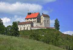
The Waldburg (English: Forest castle) is the ancestral castle of the stewards and imperial princes of the nobility gender with the same name (House of Waldburg). It dates from the 12th century and stands on the march of the municipality Waldburg in the district of Ravensburg, applies as one of the best preserved medieval buildings, and is one of the landmarks and the highest point in Upper Swabia.[2]
Geographical situation

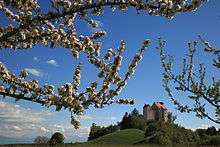
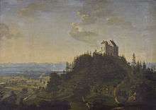
The Waldburg is a Hilltop castle located on a natural elevation, a drumlin from the last glacial period, at 772 metres (2,533 ft) height above sea level. The raised situation with view (when suitable weather conditions) to the west up to the Hohentwiel near Singen, to the north up to the Ulm Minster, to the east far back in the Alpine foothills and southwards far into the Swiss Alps and the Lake Constance made the Waldburg to an important trigonometric point also for land surveying in the early 19th century of the ordnance survey. The steepen drumlin already offers by his very big slope angle an almost ideal military protection for a castle construction, however, complicated also the building and expansion more than seven centuries considerably.
The hill castle was very woody till the eighties of the 20th century. The view at the castle was moved again in the old condition for the public reopening in 1996 by specific deforestation in the beginning of the nineties. During the day, as well as at night with lighting, the castle is a very striking and important landmark in Upper Swabian.
History

The first foundation of the castle goes back to the 11th century. In this time the family of Waldburg received an official fief from the Guelphs. In the first half of the 13th century the castle was radically rebuilt, the palas was anew established up to the second upper floor.
Under Emperor Frederick II the Imperial Regalia were kept in the castle from 1220 to at least 1240. In 1327 the church Saint Magnus was built at feet of the castle.
At the middle of the 16th century under steward Georg IV of Waldburg the castle was developed to a residence similar like a palace. From the 17th century the castle was inhabited only sporadically by the family of Waldburg and the building activity decreased.
Present utilization

Today the Schloss accommodates a museum and is opened for sightseeing during the warm seasons from early April until late October.[1] Guided tours are held on weekends and holidays at 1:30 pm and 3:00 pm. At the top of the roof there is a vista platform with a look around as far as eye can see.[4]
The museum shows exhibits to the history of the castle from the Middle Ages on the basis of documents, paintings as well as fitments and basic commodities and to the development of the ordnance survey. The walking tour begins in the ground floor with the late Middle Ages and ends in the third upper floor with the collections of the 19th and 20th century. The Holy Lance, the Imperial Sceptre and the Imperial Orb are exhibited as replicas, since 2013 there is also presented a copy of the Imperial Crown.
A special feature of the exhibition is a Facsimile of the printed wall map of the world by German cartographer Martin Waldseemüller where the continent and the name America appeared for the first time, originally published in April 1507.[5] The Federal Republic of Germany consigned the original in 2007 to the Library of Congress in Washington, DC.[6]
The castle chapel is used for church weddings. Parts of the museum and the vaults are also available for wedding celebrations. The Burgschenke, the castle inn, is the former kitchen in the imperial castle; there are offered dishes after original recipes of the Medieval cuisine.[2]
See also
References
- 1 2 Christoph Freiherr Schenck zu Schweinsberg. "Waldburg Castle". Schenck's Castles & Gardens. Retrieved 14 April 2014.
- 1 2 Max Haller. "Waldburg Castle - Ritteressen im ältesten Veranstaltungsraum" [Knight's Dinner in the eldest hosting room]. kunst, design & restaurant. Retrieved 21 April 2014.
- ↑ John R. Hébert (September 2003). "The Map That Named America". Washington, DC: Library of Congress. Retrieved 16 April 2014.
- ↑ "Waldburg Castle museum". Lindau: Lindauer Hof. Retrieved 8 May 2014.
- ↑ "Museum on the Waldburg" (JavaScript). Internationale Bodensee Tourismus GmbH. Retrieved 14 April 2014.
- ↑ Martin Waldseemüller. "Universalis cosmographia secundum Ptholomaei traditionem et Americi Vespucii alioru[m]que lustrationes.". Washington, DC: Library of Congress. LCCN 2003626426. Retrieved 18 April 2014.
External links
| Wikimedia Commons has media related to |

