Welham, Leicestershire
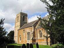
Church of St Andrew, Welham
Welham is a small village and civil parish in the Harborough district of Leicestershire, England.[1][2] Welham lies 4 miles (6 km) north-east of Market Harborough. The village is situated on the north bank of the River Welland, which forms the border with the neighbouring county of Northamptonshire.[1] The population is included in the civil parish of Slawston.
According to the 2001 census the parish had a population of 40. There is a public house, The Old Red Lion.[3]
References
- 1 2 Ordnance Survey: Landranger map sheet 141 Kettering & Corby (Market Harborough & Stamford) (Map). Ordnance Survey. 2014. ISBN 9780319229866.
- ↑ "Ordnance Survey Election Maps". www.ordnancesurvey.co.uk. Ordnance Survey. Retrieved 3 April 2016.
- ↑ "The Old Red Lion , Welham". www.king-henrys-taverns.co.uk. Retrieved 11 April 2016.
External links
![]() Media related to Welham, Leicestershire at Wikimedia Commons
Media related to Welham, Leicestershire at Wikimedia Commons
Coordinates: 52°31′30″N 0°52′23″W / 52.525°N 0.873°W
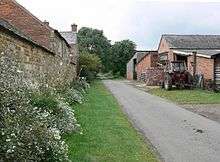
Manor Farm in Welham, Leicestershire - geograph.org.uk - 570157
This article is issued from Wikipedia - version of the 6/23/2016. The text is available under the Creative Commons Attribution/Share Alike but additional terms may apply for the media files.
