Whiting Township, Jackson County, Kansas
| Whiting Township | |
|---|---|
| Township | |
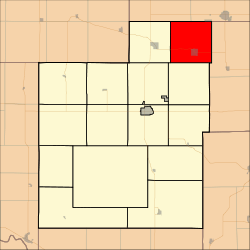 Location in Jackson County | |
| Coordinates: 39°36′10″N 95°35′51″W / 39.60278°N 95.59750°WCoordinates: 39°36′10″N 95°35′51″W / 39.60278°N 95.59750°W | |
| Country | United States |
| State | Kansas |
| County | Jackson |
| Area | |
| • Total | 36 sq mi (93.23 km2) |
| • Land | 35.96 sq mi (93.13 km2) |
| • Water | 0.04 sq mi (0.11 km2) 0.12% |
| Elevation | 1,020 ft (311 m) |
| Population (2000) | |
| • Total | 362 |
| • Density | 10.1/sq mi (3.9/km2) |
| GNIS feature ID | 0473239 |
Whiting Township is a township in Jackson County, Kansas, USA. As of the 2000 census, its population was 362.
History
Whiting Township was formed in 1872.[1]
Geography
Whiting Township covers an area of 36 square miles (93.23 square kilometers); of this, 0.04 square miles (0.11 square kilometers) or 0.12 percent is water. The stream of Muddy Creek runs through this township.
Cities and towns
Adjacent townships
- Horton Township, Brown County (northeast)
- Mission Township, Brown County (northeast)
- Grasshopper Township, Atchison County (east)
- Straight Creek Township (south)
- Liberty Township (southwest)
- Netawaka Township (west)
- Powhattan Township, Brown County (northwest)
Cemeteries
The township contains one cemetery, Spring Hill.
Major highways
References
- ↑ Barr, Elizabeth N. (1907). Business directory and history of Jackson County. p. 13.
External links
Municipalities and communities of Jackson County, Kansas, United States | ||
|---|---|---|
| Cities | 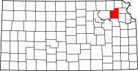 | |
| Unincorporated communities | ||
| Indian reservations | ||
| Townships | ||
| Footnotes | ‡This populated place also has portions in an adjacent county or counties | |
This article is issued from Wikipedia - version of the 11/1/2016. The text is available under the Creative Commons Attribution/Share Alike but additional terms may apply for the media files.