Znojile, Zagorje ob Savi
| Znojile | |
|---|---|
 | |
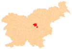
 Znojile Location in Slovenia | |
| Coordinates: 46°10′39.39″N 14°59′11.04″E / 46.1776083°N 14.9864000°ECoordinates: 46°10′39.39″N 14°59′11.04″E / 46.1776083°N 14.9864000°E | |
| Country |
|
| Traditional region | Upper Carniola |
| Statistical region | Central Sava |
| Municipality | Zagorje ob Savi |
| Area | |
| • Total | 5.3 km2 (2.0 sq mi) |
| Elevation | 513.7 m (1,685.4 ft) |
| Population (2002) | |
| • Total | 144 |
| [1] | |
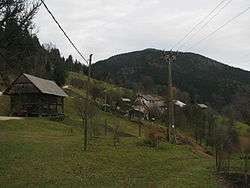
Znojile (pronounced [znɔˈjiːlɛ]) is a settlement in the hills north of the Zagorje ob Savi in central Slovenia. The area is part of the traditional region of Upper Carniola. It is now included with the rest of the Municipality of Zagorje ob Savi in the Central Sava Statistical Region.[2]
Name
The name Znojile is derived from *znoji(d)lo 'sunny or sun-facing area' from the verb *znojiti 'to be warmed by the sun'. The name therefore refers to the geographical orientation of the place.[3]
Church
The local church, built on a hill northeast of the settlement, is dedicated to Saint Leonard. It is a Gothic building that was restyled in the Baroque in the mid-18th century.[4]
References
- ↑ Statistical Office of the Republic of Slovenia Archived November 18, 2008, at the Wayback Machine.
- ↑ Zagorje ob Savi municipal site Archived March 6, 2012, at the Wayback Machine.
- ↑ Snoj, Marko. 2009. Etimološki slovar slovenskih zemljepisnih imen. Ljubljana: Modrijan and Založba ZRC, p. 483.
- ↑ Slovenian Ministry of Culture register of national heritage Archived July 12, 2010, at the Wayback Machine. reference number ešd 1722
External links
This article is issued from Wikipedia - version of the 11/17/2016. The text is available under the Creative Commons Attribution/Share Alike but additional terms may apply for the media files.

