Carmo da Cachoeira

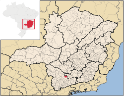
Location of Carmo da Cachoeira in the state of Minas Gerais
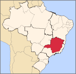
Carmo da Cachoeira is a Brazilian municipality in the south of the state of Minas Gerais. In 2007 its estimated population was 11,656 in a total area of 506 km². The elevation is 959 meters.
Carmo da Cachoeira is part of the IBGE statistical microregion of Varginha. It is 35 km. northeast of that regional center and is just off the important BR-381 highway. The distance to state capital, Belo Horizonte is 274 km.
Climate
The climate is mile with average temperatures varying between 19 and 25 degrees. In the summer the maximum can reach 34C and in the winter it can go down as low as 2C.
Economy
The main economic activities are coffee growing and milk production. Coffee alone was planted in 9,000 hectares (2006). There was also cultivation of corn (4,000 ha.), beans, sugarcane, and potatoes. In 2006 there were 532 rural producers with a total agricultural area of 36,221 ha. Over 6,300 people were dependent on agriculture. There was one financial institution.
Health
In the health sector there were 4 public and 1 private clinics. The nearest hospital was in Varginha. In the educational sector there were 6 primary schools and 1 middle school.
- MHDI: .744
- State ranking: 330 out of 853 municipalities
- National ranking: 2,040 out of 5,138 municipalities
- Life expectancy: 72
- Literacy rate: 84 For the complete list see Frigoletto
See also
References
|
|---|
|
|
|
| Mesoregion Campo das Vertentes |
|---|
| Barbacena | |
|---|
| Lavras | |
|---|
| São João del Rei | |
|---|
|
| |
|
| Mesoregion Central Mineira |
|---|
| Bom Despacho | |
|---|
| Curvelo | |
|---|
| Três Marias | |
|---|
|
|
|
| Mesoregion Jequitinhonha |
|---|
| Almenara | |
|---|
| Araçuaí | |
|---|
| Capelinha | |
|---|
| Diamantina | |
|---|
| Pedra Azul | |
|---|
|
|
|
| Mesoregion Metropolitana de Belo Horizonte |
|---|
| Belo Horizonte | |
|---|
| Conceição do Mato Dentro | |
|---|
| Conselheiro Lafaiete | |
|---|
| Itabira | |
|---|
| Itaguara | |
|---|
| Ouro Preto | |
|---|
| Pará de Minas | |
|---|
| Sete Lagoas | |
|---|
|
|
|
| Mesoregion Noroeste de Minas |
|---|
| |
|
|
| Mesoregion Norte de Minas |
|---|
| Bocaiúva | |
|---|
| Grão Mogol | |
|---|
| Janaúba | |
|---|
| Januária | |
|---|
| Montes Claros | |
|---|
| Pirapora | |
|---|
| Salinas | |
|---|
|
|
|
| Mesoregion Oeste de Minas |
|---|
| Campo Belo | |
|---|
| Divinópolis | |
|---|
| Formiga | |
|---|
| Oliveira | |
|---|
| Piui | |
|---|
|
|
|
| Mesoregion Sudoeste de Minas |
|---|
| Alfenas | |
|---|
| Andrelândia | |
|---|
| Itajubá | |
|---|
| Passos | |
|---|
| Poços de Caldas | |
|---|
| Pouso Alegre | |
|---|
| Santa Rita do Sapucaí | |
|---|
| São Lourenco | |
|---|
| São Sebastiao do Paraíso | |
|---|
| Varginha | |
|---|
|
|
|
| Mesoregion Triângulo Mineiro/Alto Paranaiba |
|---|
| Araxá | |
|---|
| Frutal | |
|---|
| Ituiutaba | |
|---|
| Patos de Minas | |
|---|
| Patrocínio | |
|---|
| Uberaba | |
|---|
| Uberlândia | |
|---|
|
|
|
| Mesoregion Vale do Mucuri |
|---|
| |
|
|
| Mesoregion Zona da Mata |
|---|
| Cataguases | |
|---|
| Juiz de Fora | |
|---|
| Manhuaçu | |
|---|
| Muriaé | |
|---|
| Ponte Nova | |
|---|
| Ubá | |
|---|
| Viçosa | |
|---|
|
|
|
| Mesoregion Vale do Rio Doce |
|---|
| Aimorés | |
|---|
| Caratinga | |
|---|
| Governador Valadares | |
|---|
| Guanhães | |
|---|
| Ipatinga | |
|---|
| Mantena | |
|---|
| Peçanha | |
|---|
|
|

