Casefabre
| Casefabre | |
|---|---|
|
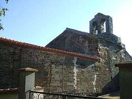
The church of Saint-Martin, in Casefabre | |
 Casefabre | |
|
Location within Occitanie region  Casefabre | |
| Coordinates: 42°37′01″N 2°36′56″E / 42.6169°N 2.6156°ECoordinates: 42°37′01″N 2°36′56″E / 42.6169°N 2.6156°E | |
| Country | France |
| Region | Occitanie |
| Department | Pyrénées-Orientales |
| Arrondissement | Prades |
| Canton | Vinça |
| Intercommunality | Roussillon Conflent |
| Government | |
| • Mayor (2014–2020) | Daniel Moragas |
| Area1 | 6.99 km2 (2.70 sq mi) |
| Population (2013)2 | 41 |
| • Density | 5.9/km2 (15/sq mi) |
| Time zone | CET (UTC+1) |
| • Summer (DST) | CEST (UTC+2) |
| INSEE/Postal code | 66040 / 66130 |
| Elevation |
236–664 m (774–2,178 ft) (avg. 557 m or 1,827 ft) |
|
1 French Land Register data, which excludes lakes, ponds, glaciers > 1 km² (0.386 sq mi or 247 acres) and river estuaries. 2 Population without double counting: residents of multiple communes (e.g., students and military personnel) only counted once. | |
Casefabre (Catalan: Casafabre) is a commune in the Pyrénées-Orientales department in southern France.
Geography
Caramany is located in the canton of Vinça and in the arrondissement of Prades.
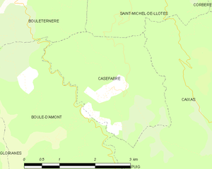
Map of Casefabre and its surrounding communes
Population
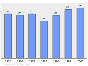
Population 1962-2008
See also
References
| Wikimedia Commons has media related to Casefabre. |
This article is issued from Wikipedia - version of the 1/26/2016. The text is available under the Creative Commons Attribution/Share Alike but additional terms may apply for the media files.