Serralongue
| Serralongue | |
|---|---|
|
The junction of Paul Santena road and Abdon Poggi road, in Serralongue | |
 Serralongue | |
|
Location within Occitanie region 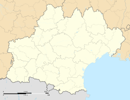 Serralongue | |
| Coordinates: 42°23′54″N 2°33′23″E / 42.3983°N 2.5564°ECoordinates: 42°23′54″N 2°33′23″E / 42.3983°N 2.5564°E | |
| Country | France |
| Region | Occitanie |
| Department | Pyrénées-Orientales |
| Arrondissement | Céret |
| Canton | Prats-de-Mollo-la-Preste |
| Intercommunality | Haut Vallespir |
| Government | |
| • Mayor (2008–2014) | Jean-Marie Bosch |
| Area1 | 23.04 km2 (8.90 sq mi) |
| Population (2006)2 | 262 |
| • Density | 11/km2 (29/sq mi) |
| Time zone | CET (UTC+1) |
| • Summer (DST) | CEST (UTC+2) |
| INSEE/Postal code | 66194 / 66230 |
| Elevation |
478–1,407 m (1,568–4,616 ft) (avg. 714 m or 2,343 ft) |
|
1 French Land Register data, which excludes lakes, ponds, glaciers > 1 km² (0.386 sq mi or 247 acres) and river estuaries. 2 Population without double counting: residents of multiple communes (e.g., students and military personnel) only counted once. | |

Serralongue (Catalan: Serrallonga) is a commune in the Pyrénées-Orientales department in southern France.
Geography
Serralongue is located in the canton of Prats-de-Mollo-la-Preste and in the arrondissement of Céret.
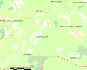
Map of Serralongue and its surrounding communes
Population

Population 1962-2008
See also
References
| Wikimedia Commons has media related to Serralongue. |
This article is issued from Wikipedia - version of the 2/10/2016. The text is available under the Creative Commons Attribution/Share Alike but additional terms may apply for the media files.