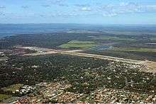
Hervey Bay Airport
| Hervey Bay Airport | |||||||||||
|---|---|---|---|---|---|---|---|---|---|---|---|
 | |||||||||||
| IATA: HVB – ICAO: YHBA | |||||||||||
| Summary | |||||||||||
| Airport type | Public | ||||||||||
| Operator | Fraser Coast Regional Council | ||||||||||
| Serves | Hervey Bay, Queensland, Australia | ||||||||||
| Elevation AMSL | 60 ft / 18 m | ||||||||||
| Coordinates | 25°19′08″S 152°52′49″E / 25.31889°S 152.88028°ECoordinates: 25°19′08″S 152°52′49″E / 25.31889°S 152.88028°E | ||||||||||
| Website | HerveyBayAirport.com.au | ||||||||||
| Map | |||||||||||
 YHBA Location in Queensland | |||||||||||
| Runways | |||||||||||
| |||||||||||
| Statistics (2010-2011[1]) | |||||||||||
| |||||||||||
Hervey Bay Airport (IATA: HVB[4], ICAO: YHBA) is the main airport for the city of Hervey Bay, Queensland, Australia and the Fraser Coast region which incorporates the nearby city of Maryborough.
The airport, which is located 5 nautical miles (9.3 km; 5.8 mi) southeast of Pialba,[2] re-opened in mid-2005, after the existing airfield underwent an $11.5 million upgrade which included the construction of a new terminal building and the extension of the existing 1,500 m (4,921 ft) runway to 2,000 m (6,562 ft) to accommodate jet services from Virgin Australia.
Up until September 2006, Sunshine Express Airlines provided daily services to the airport from Brisbane. The airline ceased all scheduled operations on 1 October 2006 after a proposed acquisition by Regional Express Airlines was terminated and an intention by QantasLink for the introduction of Brisbane services was announced.[5][6][7]
In 2006, the airport was the fastest growing in Queensland with passenger numbers almost doubling.[8] Currently, plans are underway to further upgrade the airport to handle more jet services from Sydney and possibly Melbourne. These plans involve the extension of the terminal to twice its current size, as well as a new cross runway (smaller than the main runway) to be used for general aviation purposes.[9][10]
Facilities
The airport resides at an elevation of 60 ft (18 m) above sea level. It has one runway designated 11/29 with an asphalt surface measuring 2,000 m × 30 m (6,562 ft × 98 ft).[2]
Airlines and destinations
| Airlines | Destinations |
|---|---|
| Air Fraser | Scenic Chartered Flights to east Fraser Island |
| QantasLink operated by Cobham Aviation Services Australia | Sydney |
| QantasLink operated by Sunstate Airlines | Brisbane |
| SEAIR Pacific | Lady Elliot Island |
| Virgin Australia | Sydney |
Statistics
Hervey Bay Airport was ranked 38th in Australia for the number of revenue passengers served in financial year[1] 2010-2011.[3]
| Year[1] | Revenue passengers | Aircraft movements |
|---|---|---|
| 2001-02 | 30,795 | 2,906 |
| 2002-03 | 28,181 | 2,108 |
| 2003-04 | 31,342 | 2,140 |
| 2004-05 | 35,470 | 2,584 |
| 2005-06 | 140,863 | 3,818 |
| 2006-07 | 189,429 | 3,228 |
| 2007-08 | 210,740 | 3,270 |
| 2008-09 | 201,359 | 3,249 |
| 2009-10 | 143,099 | 2,918 |
| 2010-11 | 158,591 | 2,954 |
See also
References
- 1 2 3 Fiscal year 1 July - 30 June
- 1 2 3 YHBA – Hervey Bay (PDF). AIP En Route Supplement from Airservices Australia, effective 10 November 2016, Aeronautical Chart
- 1 2 3 "Airport Traffic Data 1985-86 to 2010-11". Bureau of Infrastructure, Transport and Regional Economics (BITRE). May 2012. Archived from the original on 24 March 2012. Retrieved 8 May 2012. Refers to "Regular Public Transport (RPT) operations only"
- ↑ "Hervey Bay Airport (HVB / YHBA)". Aviation Safety Network.
- ↑ "Sunshine Express pulls out of scheduled flights". Australian Broadcasting Association. Retrieved 2007-05-07.
- ↑ "Rex Terminates Deal with Sunshine Express". Regional Express Holdings Limited. Retrieved 2007-05-07.
- ↑ "QantasLink to Launch New Services to Hervey Bay and Biloela". Qantas Airways Limited. Retrieved 2007-05-07.
- ↑ Daryl Passmore (29 April 2007). "Airports on a high". The Sunday Mai. Queensland Newspapers. Retrieved 14 March 2011.
- ↑ "Hervey Bay City Council - Airport Master Plan". Hervey Bay City Council. Archived from the original on 2007-08-29. Retrieved 2007-05-07.
- ↑ "Hervey Bay-Melbourne route sought". The Australian. Retrieved 2007-05-07.