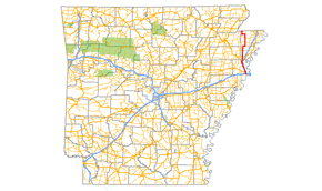
Arkansas Highway 77
| ||||
|---|---|---|---|---|
 | ||||
| Route information | ||||
| Maintained by AHTD | ||||
| Length: | 66.70 mi[1] (107.34 km) | |||
| Existed: | 1926 – present | |||
| Major junctions | ||||
| South end: |
| |||
|
| ||||
| North end: |
| |||
| Location | ||||
| Counties: | Crittenden, Mississippi | |||
| Highway system | ||||
| ||||

Highway 77 (AR 77, Ark. 77, and Hwy. 77) is a north–south[a 1] state highway in East Arkansas. The route of 66.70 miles (107.34 km) runs from US 70 in West Memphis north along Interstate 55 to the Missouri state line.[3]
Route description

AR 77 begins at US 70 in West Memphis and runs north to cross I-40/I-55/US 61/US 64/US 65/US 79. The route continues north as a former alignment of US 63 until Turrell. AR 77 also meets AR 42 in Turrell before meeting I-55/US 61/US 63 as well as Interstate 555 at a very large intersection north of town. US 61 becomes a frontage road with I-55, while AR 77 follows Future I-555/US 63 north to Gilmore. The route then turns south and runs as a frontage road along I-555/US 63, curving along I-55 and eventually facing north toward Mississippi County.
The highway becomes a minor route, passing through rural Crittenden and Mississippi Counties.[2] AR 308 briefly concurs with AR 77 in southern Mississippi County. AR 77 also crosses AR 118, AR 14/AR 297, and AR 140 south of Etowah.
AR 77 continues north to a short concurrency with AR 158 before entering Manila. AR 77 meets AR 18 before exiting Manila northbound. AR 119 concurs with AR 77 west to Leachville, after which AR 77 trails north to terminate at Route 108.
History
Between Turrell and West Memphis, Highway 77 runs on the former alignment of US 61. The route was extended along the former US 61 segment on August 22, 1956.[4]
Major intersections
Mile markers reset at concurrencies.
| County | Location | mi[1] | km | Destinations | Notes |
|---|---|---|---|---|---|
| Crittenden | West Memphis | 0.00 | 0.00 | Southern terminus | |
| 1.08 | 1.74 | I-40 exits 276 (eastbound) and 278 (westbound); I-55 exit 7 (southbound) | |||
| 2.12 | 3.41 | ||||
| Marion | 5.10 | 8.21 | |||
| Clarkedale | 12.00 | 19.31 | |||
| Turrell | 16.03 | 25.80 | |||
| 17.90 | 28.81 | South end of US 61 north overlap (southbound only) | |||
| North end of US 61 north overlap (southbound only); south end of future I-55 / US 63 overlap; I-55 exit 23; future I-555 exits 1A (south) and 1B (north); no direct access from AR 77 north to I-55 south | |||||
| Gilmore | 0.00 | 0.00 | North end of future I-555 / US 63 overlap; AR 77 north follows exit 2 | ||
| Mississippi | Dimple | 7.27 | 11.70 | South end of AR 308 overlap | |
| | 8.17 | 13.15 | North end of AR 308 overlap | ||
| | 10.66 | 17.16 | |||
| | 17.18 | 27.65 | |||
| | 19.80 | 31.87 | |||
| | 23.33 | 37.55 | |||
| Etowah | 24.33 | 39.16 | South end of AR 140 overlap | ||
| Athelstan | 0.00 | 0.00 | North end of AR 140 overlap | ||
| Carroll's Corner | 2.09 | 3.36 | |||
| | 3.99 | 6.42 | South end of AR 158 overlap | ||
| Floodway | 5.50 | 8.85 | North end of AR 158 overlap | ||
| Manila | 12.02 | 19.34 | |||
| 12.21 | 19.65 | South end of AR 18 overlap | |||
| 0.00 | 0.00 | North end of AR 18 overlap | |||
| 0.33 | 0.53 | ||||
| Poplar Corner | 3.32 | 5.34 | South end of AR 119 overlap | ||
| Leachville | 7.99 | 12.86 | North end of AR 119 overlap | ||
| Arkmo | 12.26 | 19.73 | Missouri state line | ||
1.000 mi = 1.609 km; 1.000 km = 0.621 mi
| |||||
Notes
- ↑ Although highways in the United States run from south to north and west to east, the Arkansas State Highway and Transportation Department lists Highway 77 beginning at the Mississippi County line and running south to West Memphis.[2]
- ↑ Military Road west of Highway 77 is US 64, even though the route also concurs with I-55/US 63/US 61 west of the intersection.[5] This is a leftover alignment prior to building I-55.
References
- 1 2 Planning and Research Division (2010). "Arkansas Road Log Database". Arkansas State Highway and Transportation Department. Archived from the original (Database) on 23 June 2011. Retrieved June 9, 2011.
- 1 2 General Highway Map (PDF) (Map) (Mississippi County ed.). Arkansas State Highway and Transportation Department. Retrieved June 22, 2011.
- ↑ General Highway Map (PDF) (Map) (Crittenden County ed.). Arkansas State Highway and Transportation Department. Retrieved June 22, 2011.
- ↑ "Minutes of the Meeting" (PDF). Arkansas State Highway Commission. August 22, 1956. p. 1919. Retrieved January 16, 2013.
- ↑ Route and Section Map (PDF) (Map) (Crittenden County ed.). Arkansas State Highway and Transportation Department. Retrieved June 22, 2011.
Roads of Memphis | |||||||||||
|---|---|---|---|---|---|---|---|---|---|---|---|
| Interstate Highways | 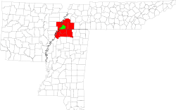 | ||||||||||
| U.S. Highways | |||||||||||
| State Highways |
| ||||||||||
| Other Highways | |||||||||||
