Lincoln, New Zealand
| Lincoln | |
|---|---|
| Minor urban area | |
|
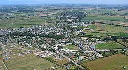
Looking southwest across Lincoln from the air, December 2005 | |
 Lincoln Location of Lincoln | |
| Coordinates: 43°39′S 172°29′E / 43.650°S 172.483°ECoordinates: 43°39′S 172°29′E / 43.650°S 172.483°E | |
| Country |
|
| Island | South Island |
| Region | Canterbury |
| Territorial authority | Selwyn District |
| Area | |
| • Total | 13.28 km2 (5.13 sq mi) |
| Elevation | 10 m (30 ft) |
| Population (June 2016)[1] | |
| • Total | 5,240 |
| • Density | 390/km2 (1,000/sq mi) |
| Time zone | NZST (UTC+12) |
| • Summer (DST) | NZDT (UTC+13) |
| Postcode | 7608 |
| Local iwi | Ngāi Tahu |
Lincoln is a town in the Selwyn District, in the Canterbury Region of New Zealand's South Island. The town is located on the Canterbury Plains to the west of Banks Peninsula, 22 kilometres southwest of Christchurch. The town has a population of 5,240 (June 2016),[1] making it the second largest town in the Selwyn District behind nearby Rolleston.
Lincoln is a satellite town of Christchurch; at the 2006 Census, 53% of employed Lincoln residents worked in the city.[2] The town is home to Lincoln University, the oldest agricultural tertiary institution in the Southern Hemisphere and the smallest of New Zealand's eight universities.
History
In 1862 James Edward FitzGerald of ‘The Springs’ subdivided some of his freehold land for the new township of Lincoln, named after the Earl of Lincoln, a foundation member of the Canterbury Association and from 1851 a member of the management committee. The site of Lincoln on the L1 River would allow for a flour mill to be built to service the growing farming district. Lincoln was laid out in a grid layout and FitzGerald named the four belts North, East, South and West and the cross streets after his own children Robert, Maurice and William. The main streets James, Edward and Gerald were names after himself.
The new township steadily grew and by 1873 Lincoln had a post office, butcher, brewers, a baker and confectioner, a storekeeper who had a hotel, a wheelwright and a carpenter, and a blacksmith. The peaceful quality of Lincoln changed with the arrival of the railway line in 1875 and the opening of the Little River line in 1886.[3]
On 26 April 1875, a branch line railway was opened to Lincoln from a junction with the Main South Line in Hornby. This line became the Southbridge Branch. Within a few years, Lincoln became a junction itself, with the Little River Branch diverging from the Southbridge Branch in Lincoln. This branch opened to Birdling's Flat on 16 May 1882 and Little River itself on 11 March 1886. On 30 June 1962, Lincoln became a railway terminus when the Little River Branch and the Lincoln-Southbridge section of the Southbridge Branch were both closed. The railway did not last much longer in Lincoln, closing on 1 December 1967. Today, the Little River Rail Trail is being established along the railway's old route. The Prebbleton to Lincoln leg of the route was opened on 30 November 2006. The trail is used extensively for recreation.
Educational, research institutions and amenities
Lincoln has two schools, one primary and one secondary.
- Lincoln Primary School is a state full primary (Year 1–8) school. It was established in 1866 and has a roll of 530 students as of July 2016.[4]
- Lincoln High School is a state secondary (Year 9–13) school. It was established in 1959 and has a roll of 1667 students as of July 2016.[4]
Lincoln is the site of Lincoln University. As well as the university, there are a number of other research facilities in Lincoln, including AgResearch, Institute for Plant and Food Research, FAR (Foundation for Arable Research), and Landcare Research. Over 400 people are employed at these organisations making Lincoln a busy little country village.
Lincoln also has a maternity hospital, kindergarten and golf course. It is also the home of the New Zealand Cricket Academy.
Lincoln also hosts the first New Zealand supermarket to have wind turbines generating some of its power: Lincoln New World. The supermarket was built with a number of sustainable initiatives in keeping with the Enviro town it is servicing.[5]
References
- 1 2 "Subnational Population Estimates: At 30 June 2016 (provisional)". Statistics New Zealand. 21 October 2016. Retrieved 21 October 2016. For urban areas, "Subnational population estimates (UA, AU), by age and sex, at 30 June 1996, 2001, 2006-16 (2017 boundary)". Statistics New Zealand. 21 October 2016. Retrieved 21 October 2016.
- ↑ "Commuting patterns in Christchurch -- Commuting patterns in New Zealand, 1996-2006". Statistics New Zealand. Retrieved 7 January 2015.
- ↑ Singleton, George (2007). Ellesmere, The Jewel in the Canterbury Crown. Selwyn District Council. pp. 295–298. ISBN 978-0-473-11875-4.
- 1 2 "Directory of Schools - as at 2 August 2016". New Zealand Ministry of Education. Retrieved 2016-08-16.
- ↑ Greenhill, Marc (10 September 2009). "New Zealand's first wind powered supermarket". Stuff.co.nz. Retrieved 3 October 2014.
