List of canals of the United Kingdom
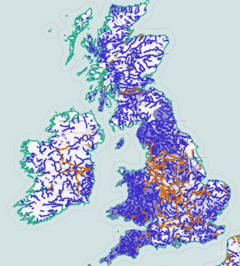
Map showing canals of the British Isles. Canals in orange, rivers in blue, streams in grey.
Canals of the United Kingdom; see also Canals of the United Kingdom.
The following list includes some systems that are navigable rivers with sections of canal (e.g. Aire and Calder Navigation) as well as "completely" artificial canals (e.g. Rochdale Canal).
Canals in England
This includes only canals that are currently open or being restored and are at least partly in England. See also Abandoned Canals. Click on the diamond to sort by any column.
| Canal | Length | Locks | Max boat length (ft) | Width (ft) | Where[1] | Year opened | Year abandoned | Year restored |
|---|---|---|---|---|---|---|---|---|
| Aire and Calder Navigation | 34 mi (55 km) | 12 | 200 | 20 | NE | 1704 | ||
| Andover Canal | 22 mi (35 km) | 24 | 65 | 8.5 | S | 1794 | 1859 | |
| Ashby-de-la-Zouch Canal | 22 mi (35 km) | 0 | 72 | 7 | M | 1804 | 1918, 1966 | |
| Ashton Canal | 6 mi (10 km) | 18 | 70 | 7 | NW | 1796 | 1961 | 1974 |
| Barnsley Canal | 14.5 mi (23 km) | 15 | 84 | 14 | NW | 1799 | 1893, 1946 | in process |
| Basingstoke Canal | 32 mi (51 km) | 29 | 68 | 13 | S | 1794 | 1910 | 1991 |
| Beverley Beck | 0.5 mi (1 km) | 1 | 65 | 17.5 | NE | 1744 | ||
| Birmingham and Warwick Junction Canal[2] | 2.5 mi (4 km) | 6 | 70 | 7 | M | 1844 | ||
| Birmingham Canal Navigations[3] | 29.8 mi (48 km) | 34 | 70 | 7 | M | 1772-1794 | ||
| Birmingham and Fazeley Canal[4] | 20.5 mi (33 km) | 44 | 70 | 7 | M | 1789 | ||
| Blyth Navigation | 7 mi (11 km) | 6 | 50 | 14 | EA | 1761 | 1911 | |
| Bridgewater Canal | 40 mi (64 km) | 0 | 72 | 14.75 | NW | 1761 | ||
| Bridgwater and Taunton Canal, Somerset | 14.5 mi (23 km) | 6 | 50 | 9.83 | SW | 1827 | 1907 | 1994 |
| Bude Canal | 35 mi (56 km) | 2[5] | 20 | 5.5 | SW | 1823 | 1891 | |
| Calder and Hebble Navigation | 21.5 mi (35 km) | 38 | 55 | 14 | NE | 1794 | ||
| Caldon Canal | 18 mi (29 km) | 17 | 72 | 7 | NM | 1779 | ||
| Chelmer and Blackwater Navigation | 13.8 mi (22 km) | 13 | 60 | 16 | EA | 1797 | ||
| Chesterfield Canal | 45.5 mi (73 km), now 31.5 mi (51 km) | 62 | 72 | 7 | NE | 1777 | 1907 part | |
| Chichester Canal | 4.5 mi (7 km) | 3 | 85 | 18 | S | 1822 | 1906 | |
| Coventry Canal | 32.7 mi (53 km) | 13 | 72 | 7 | M | 1769, 1788 | ||
| Dearne and Dove Canal[6] | 9.8 mi (16 km) | 19 | 58 | 14.83 | NE | 1804 | 1961 | |
| Derby Canal | 14 mi (23 km) | 17 | 72 | 14 | NE | 1796 | ||
| Derby and Sandiacre Canal | 14.5 mi (23 km) | 9 | 72 | 14 | NE | 1793 | 1964 | |
| Digbeth Branch Canal[4] | 1.25 mi (2.0 km) | 6 | 72 | 7 | M | 1799 | ||
| Driffield Navigation, East Yorkshire | 11 mi (18 km) | 6 | 61 | 14.5 | NE | 1767 | 1955 (part) | |
| Droitwich Canal | 7.3 mi (12 km) | 15 | 71.5 | 7.08 | M | 1771,1854 | 1939 | 2011 |
| Dudley Canal[4] | 10.3 mi (17 km) | M | 1770,1792 | 1948 | 1973 (part) | |||
| Erewash Canal[2] | 11.8 mi (19 km) | 14 | 78 | 12.5 | NE | 1779 | 1962 (part) | |
| Exeter Canal | 5.2 mi (8 km) | 2 | 122 | 26.25 | SW | 1563 | ||
| Fairbottom Branch Canal | 1 mi (2 km) | 0 | NW | 1792 | 1932 | |||
| Foss Dyke | 11.3 mi (18 km) | 1 | 74.5 | 15.17 | E | 1121 | ||
| Gloucester and Sharpness Canal | 16.5 mi (27 km) | 2 | 240 | 30 | SW | 1826 | ||
| Grand Junction Canal[2] | 129.4 mi (208 km) | 90 | 72 | 14.7 | M | 1800,1805 | ||
| Grand Union Canal[7] | 286.3 mi (461 km) | 236 | 72 | 14 | M | 1927 | ||
| Grand Union Canal (old)[2] | 24.3 mi (39 km) | 17 | 72 | 7 | EM | 1814 | ||
| Grand Western Canal | 10.5 mi (17 km) | 0 | SW | 1838 | ||||
| Grantham Canal | 33 mi (53 km) | 18 | 75 | 14 | EM | 1797 | 1936 | |
| Hatherton Canal[4] | 4 mi (6 km) | 8 | 70 | 7 | NM | 1860 | 1955 | |
| Herefordshire and Gloucestershire Canal | 34 mi (55 km) | 22 | 70 | 7 | W | 1798,1845 | 1881 | |
| Hertford Union Canal[2] | 1.3 mi (2 km) | 3 | 78 | 14.5 | SE | 1830 | ||
| Hollinwood Branch Canal | 4.5 mi (7 km) | 4 | 70 | 7 | NW | 1792 | 1932 | |
| Huddersfield Broad Canal | 3.8 mi (6 km) | 9 | 57.5 | 14.17 | NE | 1780 | ||
| Huddersfield Narrow Canal | 19.9 mi (32 km) | 74 | 70 | 7 | NE | 1811 | ||
| Ipswich and Stowmarket Navigation | 15.9 mi (26 km) | 15 | 55 | 14 | EA | 1793 | 1934 | |
| Islington Branch Canal | 0.6 mi (1 km) | 0 | NW | 1801 | 1952 | |||
| Kennet and Avon Canal | 86.5 mi (139 km) | 105 | 70 | 12.5 | SW | 1727,1810 | (1950)[8] | 1990 |
| Lancaster Canal | 60.9 mi (98 km) | 14 | 72 | 14.5 | NW | 1797, 1825 | 1955 | 2002 (part) |
| Leeds and Liverpool Canal | 142.6 mi (229 km) | 105 | 62[9] | 14 | NE,NW | 1816 | ||
| Leicestershire and Northamptonshire Union Canal[2] | 48 mi (77 km) | 22 | 72 | 13 | EM | 1807 | ||
| Lichfield Canal[4] | 7 mi (11 km) | 30 | 70 | 7 | M | 1797 | 1955 | |
| Limehouse Cut | 2 mi (3 km) | 0 | 88 | 19 | SE | 1766[10] | ||
| Llangollen Canal | 46.3 mi (75 km) | 21 | 70’ | 6.83 | W | 1808 | ||
| Louth Navigation | 11.8 mi (19 km) | 8 | 72 | 15 | NE | 1770 | 1924 | |
| Lydney Canal | 1 mi (2 km) | 1 | 100 | 24 | SW | 1821 | 1977 | 2005 (part) |
| Macclesfield Canal | 26.3 mi (42 km) | 13 | 70 | 7 | NW | 1831 | ||
| Manchester Bolton & Bury Canal | 12.9 mi (21 km) | 17 | 68 | 14.17 | NW | 1797,1808 | 1941,1961 | |
| Manchester Ship Canal | 37.4 mi (60 km) | 5 | 600 | 65 | NW | 1894 | ||
| Market Weighton Canal | 9.5 mi (15 km) | 1 | 70 | 14.83 | NE | 1782 | 1971[11] | |
| Melton Mowbray Navigation | 11 mi (18 km) | 12 | EM | 1797 | 1877 | |||
| Middle Level Navigations | 90 mi (145 km) | 7 | 80 | 11 | E | 1608-1832 | ||
| Montgomery Canal | 33 mi (53 km) | 24 | 70 | 6.83 | W | 1821 | 1944 | 1996 (part) |
| New Junction Canal | 5.5 mi (9 km) | 1 | 215 | 22.5 | NE | 1905 | ||
| North Walsham & Dilham Canal | 7.3 mi (12 km) | 4 | 50 | 12.33 | EA | 1826 | 1927 (part) | |
| Nottingham Canal | 14.7 mi (24 km)[12] | 18 | 81 | 14.5 | NE | 1796 | 1937 (part) | |
| Oxford Canal | 78 mi (126 km) | 43 | 70 | 6.83 | M | 1774, 1790 | ||
| Peak Forest Canal | 14.8 mi (24 km) | 16 | 70 | 7 | NW | 1805 | 1960 | 1974 |
| Pocklington Canal | 9.5 mi (15 km) | 9 | 57 | 14.25 | NE | 1818 | 1932 | |
| Regent's Canal[2] | 8.6 mi (14 km) | 13 | 72 | 14.5 | SE | 1820 | ||
| Ribble Link | 3 mi (5 km) | 9 | 62 | 10.5 | NW | 2002 | ||
| Ripon Canal | 2.5 mi (4 km) | 3 | 57 | 14.25 | NE | 1773 | 1906 | 1996 |
| River Soar Navigation[2] | 21.9 mi (35 km) | 18 | 72 | 13 | EM | 1794 | ||
| River Lee Navigation[13] | 29.1 mi (47 km) | 22 | 85 | 16 | SE | 1577, 1769 | ||
| Rochdale Canal | 32 mi (51 km) | 91 | 74 | 14.17 | NW | 1800 | ||
| Royal Military Canal | 19 mi (31 km) | 0 | SE | 1804 | ||||
| Sankey Canal | 15.2 mi (24 km) | 11 | 72 | 13.83 | NW | 1757 | 1963 | |
| Selby Canal | 6 mi (10 km) | 2 | 78.5 | 16.5 | NE | 1776 | ||
| Sheffield and South Yorkshire Navigation[14] | 28 mi (45 km) | 24 | 61.5 | 15.25 | NE | 1802 | ||
| Shrewsbury Canal | 25 mi (40 km) | 34 | 81 | 7 | W | 1797 | 1944 | |
| Shropshire Union Canal | 76.5 mi (123 km) | 51 | 72[15] | 7[16] | NM | 1835 | ||
| Sleaford Navigation | 12.5 mi (20 km) | 7 | 70 | 15 | NE | 1794 | 1940 | |
| Somerset Coal Canal | 18 mi (29 km) | SW | 1802 | 1898[17] | 1986 (part)[18] | |||
| Southwick Ship Canal | 1.75 mi (2.8 km) | 1 | 240 | 40 | SE | 1855 | ||
| Staffordshire and Worcestershire Canal | 46.1 mi (74 km) | 43 | 70 | 7 | NM | 1772 | ||
| Stainforth and Keadby Canal | 14.9 mi (24 km) | 3 | 61.67 | 17 | NE | 1802 | ||
| Stockport Branch Canal | 4.9 mi (8 km) | 0 | NW | 1797 | 1962 | |||
| Stort Navigation | 13.8 mi (22 km) | 15 | 86 | 13.25 | SE | 1769 | ||
| Stourbridge Canal | 7.8 mi (13 km) | 21 | 70 | 7 | M | 1779 | ||
| Stratford-upon-Avon Canal | 25.5 mi (41 km) | 56 | 70 | 7 | M | 1802, 1816 | ||
| Stroudwater Navigation | 8 mi (13 km) | 13 | 70 | 15.5 | SW | 1779 | ||
| Tame Valley Canal[4] | 8.5 mi (14 km) | 13 | 72 | 7 | M | 1844 | ||
| Thames and Medway Canal[19] | 6.5 mi (10 km) | 1 | 24.5 | 6.5 | SE | 1824 | 1935 | |
| Thames and Severn Canal | 28.8 mi (46 km) | 44 | 74 | 12.75 | SW | 1789 | 1933 | |
| Trent and Mersey Canal | 93.4 mi (150 km) | 76 | 72 | 7[20] | NE | 1777 | ||
| Uttoxeter Canal | 13 mi (21 km) | 19 | NM | 1811 | 1849 | 2005 (part) | ||
| Walsall Canal[4] | 9.6 mi (15 km) | 16 | 72 | 7 | M | 1785-1841 | ||
| Wardle Canal | 0.1 mi (0.2 km) | 1 | NM | 1829 | ||||
| Warwick and Napton Canal[2] | 14.2 mi (23 km) | 25 | 72 | 7[21] | M | 1794 | ||
| Warwick and Birmingham Canal[2] | 24.3 mi (39 km) | 28 | 70 | 7[21] | M | 1794 | ||
| Wednesbury Old Canal[4] | 4.4 mi (7 km) | 3 | 70 | 7 | M | 1769 | 1955 (part) | |
| Wey and Arun Junction Canal[22] | 23 mi (37 km) | 26 | 68 | 11.5 | S | 1816 | 1871 | |
| Wey and Godalming Navigations | 19.5 mi (31 km) | 16 | 72 | 13.83 | S | 1651, 1760 | ||
| Wilts and Berks Canal | 52.5 mi (84 km) | 42 | 72 | 7 | SW | 1810 | 1914 | 1995 (part) |
| Worcester and Birmingham Canal | 30 mi (48 km) | 58 | 71.5 | 7 | M | 1815 | ||
| Wyrley and Essington Canal[4] | 23.5 mi (38 km) | 39 | 70 | 7 | M | 1797 | 1900 (part) | |
Canals in Northern Ireland
_at_Broadwater%2C_near_Aghalee.jpg)
Lagan Navigational Canal (disused) at Broadwater, near Aghalee)
| Canal | Length (miles) | Locks | Year opened | Year abandoned | Year restored |
|---|---|---|---|---|---|
| Broharris Canal | 2 | 1820 | |||
| Coalisland Canal[23] | 7.2 | 7 | 1787 | 1954 | |
| Dukart's Canal | 3[5] | 1777 | 1787 | ||
| Lagan Canal | 27 | 27 | 1802 | 1958 | |
| Newry Canal | 21 | 12 | 1742 | 1938 | |
| Shannon–Erne Waterway[24] | 39 | 16 | 1780 | 1948 | 1994 |
| Strabane Canal | 4 | 2 | 1792 | 1962 | |
| Ulster Canal | 46 | 26 | 1842 | 1931 |
Canals in Scotland
| Canal | Length (miles) | Locks | Max boat length (ft) | Width (ft) | Year opened | Year abandoned | Year restored |
|---|---|---|---|---|---|---|---|
| Aberdeenshire Canal | 18 | 18 | 1805 | 1854 | |||
| Buchan Canal | |||||||
| Caledonian Canal | 62 | 29 | 150 | 35 | 1822 | ||
| Crinan Canal | 9 | 15 | 86.75 | 19.65 | 1817 | ||
| Dingwall Canal | 1.1 | 0 | 1816 | 1840 | |||
| Forth and Clyde Canal | 35 | 38 | 68.58 | 19.75 | 1790 | 1963 | 2002 |
| Glasgow, Paisley and Johnstone Canal | 11 | 0 | 1811 | 1881 | |||
| Monkland Canal | 12.25 | 18[25] | 71 | 14 | 1794 | 1942 | |
| Stevenston Canal | 2.25 | 0 | 13 | 1772 | 1830 | ||
| Union Canal[26] | 31.5 | 3[27] | 63 | 12.5 | 1822 | 1930 | 2000 |
Canals in Wales
| Canal | Length (miles) | Locks | Max boat length (ft) | Width (ft) | Year opened | Year abandoned | Year restored |
|---|---|---|---|---|---|---|---|
| Aberdare Canal | 6.75 | 2 | 1812 | 1900 | |||
| Cyfarthfa Canal | 2 | 1770's | 1830's | ||||
| Glamorganshire Canal | 25 | 52 | 1798 | 1898, 1942 | |||
| Glan-y-wern Canal | c. 1.5 | by 1790 | c. 1810 | ||||
| Kidwelly and Llanelly Canal | 18 | 8[28] | 1768, 1837 | 1865 | |||
| Llangollen Canal | 46.3 | 21 | 70 | 6.83 | 1808 | ||
| Monmouthshire, Brecon and Abergavenny Canal | 35 | 48 | 63 | 9.17 | 1796 | 1962 | 1970 |
| Montgomery Canal | 33 | 24 | 70 | 6.83 | 1821 | 1944 | 1996 (part) |
| Neath and Tennant Canal | 21.5 | 21 | 60 | 9 | 1795, 1824 | 1934 | 1990 (part) |
| Swansea Canal | 16.5 | 36 | 65 | 7.5 | 1798 | 1931 | |
Abandoned or unnavigable canals in England
| Canal | County | Length (miles) | Locks | Opened | Closed |
|---|---|---|---|---|---|
| Andover Canal | Hampshire | 22 | 24 | 1794 | 1859 |
| Arbury Canals | Warwickshire | 6 | 13 | 1786 | 1819, 1973 |
| Baybridge Canal | Sussex | 3.5 | 2 | 1826 | 1875 |
| Beaumont Cut | Essex | 0.6 | 0 | 1832 | 1932 |
| Bentley Canal | Warwickshire | 3.4 | 10 | 1845 | 1953 |
| Bradford Canal | West Yorkshire | 3.5 | 10 | 1774 | 1922 |
| Black Bear Canal | Cheshire | 8 | 1804 | 1965 | |
| Caistor Canal | Lincolnshire | 4 | 5 | 1800 | 1936 |
| Cann Quarry Canal | Devon | 2 | 1825 | 1839 | |
| Car Dyke | Lincolnshire | 85 | 0 | 120 (appr) | 1200 (appr) |
| Chard Canal | Somerset | 13.5 | 4[5] | 1842 | 1868 |
| Cinderford Canal | Gloucestershire | 1.25 | 0 | 1797 | 1810 ? |
| City Canal | London | 1 | 2 | 1805 | 1829 |
| Coombe Hill Canal | Gloucestershire | 2.75 | 1 | 1796 | 1876 |
| Charnwood Forest Canal | Leicestershire | 6 | 1794 | 1808 | |
| Cromford Canal | Derbyshire | 14.5 | 14 | 1794 | 1900 |
| Croydon Canal | London | 9.25 | 28 | 1809 | 1836 |
| Donnington Wood Canal | Shropshire | 5.5 | 1767 | 1904 | |
| Eardington Forge Canal | Shropshire | 0.5 | 1 | 1782 | 1889 |
| Fletcher's Canal | Gtr Manchester | 1.5 | 2 | 1800 | 1952 |
| Galton's Canal | Somerset | 1.4 | 1 | 1822 | 1897 |
| Glastonbury Canal | Somerset | 14 | 2 | 1834 | 1854 |
| Grand Surrey Canal | London | 4 | 1 | 1810 | 1940 |
| Grosvenor Canal | London | 0.8 | 1 | 1825 | 1858, 1925 |
| Hackney Canal | Devon | 0.6 | 1 | 1843 | 1928 |
| Hollingwood Common Canal | Derbyshire | 2 | 0 | ? | ? |
| Horncastle Canal | Lincolnshire | 11 | 12 | 1802 | 1889 |
| Itchen Navigation | Hampshire | 10 | 17 | 1710 | 1869 |
| Kensington Canal | London | 1.75 | 1 | 1828 | 1859, 1967 |
| Ketley Canal | East Shropshire | 1.5 | 1[5] | 1788 | 1880 |
| Leominster Canal | Herefordshire | 18 | 16 | 1794 | 1858 |
| Leven Canal | Yorkshire | 3.25 | 1 | 1805 | 1935 |
| Liskeard and Looe Union Canal | Cornwall | 6 | 25 | 1828 | 1910 |
| Newcastle-under-Lyme Canal | Staffordshire | 3.75 | 0 | 1800 | 1935 |
| Newport Pagnell Canal | Buckinghamshire | 1.25 | 7 | 1817 | 1864 |
| Nutbrook Canal | Derbyshire | 4.5 | 13 | 1796 | 1895 |
| Oakham Canal | Leicestershire | 15.5 | 18 | 1802 | 1847 |
| Ouse Navigation | Sussex | 22 | 19 | 1812 | 1950 |
| Par Canal | Cornwall | 2.25 | 3 | 1847 | 1873 |
| Parnall's Canal | Cornwall | 0.5 | 0 | 1720 | 1732 |
| Petworth Canal | Sussex | 1.25 | 2 | 1795 | 1826 |
| Pidcock's Canal | Gloucestershire | 1.5 | 3 | 1789 | 1845 |
| Portsmouth and Arundel Canal | Hampshire, Sussex | 28 | 6 | 1823 | 1926 |
| Rolle Canal[29] | Devon | 6 | 2[30] | 1827 | 1871 |
| Salisbury and Southampton Canal | Hampshire | 13[31] | 16 | 1802 | 1808 |
| Shropshire Canal | Shropshire | 10.5 | 3[5] | 1791 | 1912 |
| Sir John Glynne's Canal | Flintshire | 1 | 1768 | 1779 | |
| Sir Nigel Gresley's Canal | Staffordshire | 3 | 0 | 1776 | 1857 |
| Stamford Canal | Lincolnshire | 6.5 | 10 | 1670 | 1863 |
| Stover Canal | Devon | 1.7 | 5 | 1792 | 1943 |
| Tavistock Canal | Devon | 4 | 2[5] | 1803 | 1873 |
| Titchfield Canal | Hampshire | ||||
| Tremadoc Canal | Merionethshire | 1.5 | 0 | 1815 | 1840 |
| Ulverston Canal | Cumbria | 1.5 | 1 | 1796 | 1944 |
| Westport Canal | Somerset | 3.3 | 1 | 1840 | 1875 |
| Wombridge Canal | East Shropshire | 1.75 | 1[5] | 1788 | 1921 |
Proposed canal routes
Active proposals
- Bedford and Milton Keynes Waterway: Connection from Grand Union Canal at Milton Keynes to the River Great Ouse near Bedford. This link will finally enable broad-beam boats to travel from the north to the south of the inland waterway network.[32]
- Fens Waterways Link: The Fens Waterways Link comprises several new waterways and improvements to current routes. It will create new circular routes and in conjunction with the Milton Keynes and Bedford Waterway, it will be connected to the rest of the country's waterways via the Great Ouse.[33]
- Grand Union Canal (Slough Branch): Extending Slough Arm of the Grand Union Canal south to join the River Thames.[34]
- Maidenhead Waterways: Making the York Stream and other parts of the Maidenhead Waterways fully navigable for boats and linking to other nearby canals and navigable rivers.[35]
- Rother Link: Planned canal which would connect the Chesterfield Canal at Killamarsh, via the River Rother through to the Sheffield and South Yorkshire Navigation, thus creating a new cruising ring and encouraging boats to visit the Chesterfield Canal.
- Upper Avon Extension (Warwick): This proposed connection from River Avon to Grand Union Canal via Warwick is subject to some landowner opposition.[36]
Former proposals
- Grand Contour Canal: First proposed in 1943, was intended to connect the major industrial centres of London, Bristol, Southampton, Coventry, Birmingham, Nottingham, Derby, Chester, Manchester, Blackburn, Bradford, Hartlepool and Newcastle.
- London to Portsmouth canal: Proposed on several occasions, this route would utilise existing canals and rivers, with new links constructed, to provide an overland route between the cities of London and Portsmouth, removing the need to enter the English Channel.
See also
References
- ↑ M=midlands, EA=East Anglia, NE=North-East etc.
- 1 2 3 4 5 6 7 8 9 10 now part of the Grand Union Canal
- ↑ Main line, incl old main line and branches
- 1 2 3 4 5 6 7 8 9 part of Birmingham Canal Navigations
- 1 2 3 4 5 6 7 inclined planes
- ↑ South Yorkshire
- ↑ Total holdings 1929
- ↑ never officially closed but unusable till reopened
- ↑ 72 from Liverpool to Wigan incl Leigh branch
- ↑ connection to Limehouse Basin 1968
- ↑ but passage still possible
- ↑ only 1.1m remains open making 3.7m total including the Beeston cut
- ↑ includes Bow Back rivers
- ↑ the river section from Bramwith to Rotherham takes boats 229’8” long and 20’ wide
- ↑ The Middlewich branch is 70’
- ↑ The old Chester canal from Nantwich to Ellesmere Port is 9’
- ↑ The Radstock arm closed in 1898
- ↑ About 0.5m only, for moorings on the Kennet and Avon canal
- ↑ also known as the Gravesend and Rochester Canal
- ↑ Preston brook to Croxton Aqueduct is 9’ wide
- 1 2 Increased to 13' in 1933
- ↑ includes Arun Navigation
- ↑ also known as Tyrone Navigation
- ↑ Originally the Ballyconnell andl Ballinamore Canals
- ↑ an inclined plane was later used
- ↑ originally known as “Edinburgh and Glasgow Union Canal”
- ↑ includes the Falkirk Wheel
- ↑ includes 3 inclined planes
- ↑ Also known as the 'Torrington Canal
- ↑ included an inclined plane
- ↑ only part of this was built
- ↑ "Bedford & Milton Keynes Waterway". Bedford & Milton Keynes Waterway Trust. Retrieved 2007-09-23.
- ↑ "The Fens Waterways Link". Environment Agency Waterways Team. Retrieved 2007-09-23.
- ↑ "IWAAC Inland Waterway review 2006" (PDF). Inland Waterways Amenity Advisory Council. Archived from the original (pdf) on July 22, 2007. Retrieved 2007-09-23.
- ↑ "The Maidenhead River Project". Maidenhead Waterways Restoration Group. Retrieved 2007-09-23.
- ↑ "Upper Avon Extension (Proposed)". Inland Waterways Association. Archived from the original on May 2, 2007. Retrieved 2007-09-23.
This article is issued from Wikipedia - version of the 9/13/2016. The text is available under the Creative Commons Attribution/Share Alike but additional terms may apply for the media files.