Park Street (MBTA station)
PARK STREET
PARK STREET | ||||||||||||||||||||||||||||||||||||||||||||||||||||||||||||||
|---|---|---|---|---|---|---|---|---|---|---|---|---|---|---|---|---|---|---|---|---|---|---|---|---|---|---|---|---|---|---|---|---|---|---|---|---|---|---|---|---|---|---|---|---|---|---|---|---|---|---|---|---|---|---|---|---|---|---|---|---|---|---|
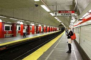 Northbound (right) and center platforms for the Red Line | ||||||||||||||||||||||||||||||||||||||||||||||||||||||||||||||
| Location |
Tremont and Park Streets Boston, MA 02108 | |||||||||||||||||||||||||||||||||||||||||||||||||||||||||||||
| Coordinates | 42°21′23″N 71°3′45″W / 42.35639°N 71.06250°WCoordinates: 42°21′23″N 71°3′45″W / 42.35639°N 71.06250°W | |||||||||||||||||||||||||||||||||||||||||||||||||||||||||||||
| Owned by | MBTA | |||||||||||||||||||||||||||||||||||||||||||||||||||||||||||||
| Line(s) | ||||||||||||||||||||||||||||||||||||||||||||||||||||||||||||||
| Platforms |
2 island platforms, 1 side platform (upper level, Green Line) 1 island platform, 2 side platforms (lower level, Red Line) | |||||||||||||||||||||||||||||||||||||||||||||||||||||||||||||
| Tracks |
4 (upper level - Green Line) 2 (lower level - Red Line) | |||||||||||||||||||||||||||||||||||||||||||||||||||||||||||||
| Connections |
| |||||||||||||||||||||||||||||||||||||||||||||||||||||||||||||
| Construction | ||||||||||||||||||||||||||||||||||||||||||||||||||||||||||||||
| Platform levels | 2 | |||||||||||||||||||||||||||||||||||||||||||||||||||||||||||||
| Disabled access | Yes | |||||||||||||||||||||||||||||||||||||||||||||||||||||||||||||
| History | ||||||||||||||||||||||||||||||||||||||||||||||||||||||||||||||
| Opened |
September 3, 1897 (upper level) March 23, 1912 (lower level) | |||||||||||||||||||||||||||||||||||||||||||||||||||||||||||||
| Rebuilt | 1915, 1936, 1977-79, 1980s, 2004, 2012 | |||||||||||||||||||||||||||||||||||||||||||||||||||||||||||||
| Traffic | ||||||||||||||||||||||||||||||||||||||||||||||||||||||||||||||
| Passengers (2013) | 19,653 (weekday average boardings)[1] | |||||||||||||||||||||||||||||||||||||||||||||||||||||||||||||
| Services | ||||||||||||||||||||||||||||||||||||||||||||||||||||||||||||||
| ||||||||||||||||||||||||||||||||||||||||||||||||||||||||||||||
| Location | ||||||||||||||||||||||||||||||||||||||||||||||||||||||||||||||
 | ||||||||||||||||||||||||||||||||||||||||||||||||||||||||||||||
Park Street is a station on the MBTA subway system, located at the intersection of Park Street and Tremont Street under Boston Common in downtown Boston. One of the two oldest stations on the "T" (the other is Boylston), Park Street is the transfer point between the Green and Red Lines, as one of the quartet of "hub stations" on the MBTA subway system. Park Street is the fourth-busiest station in the MBTA network, with an average of 19,836 entries each weekday in 2010.[1]
History
Initial construction
Tremont Street Subway
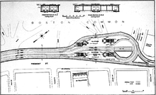
The southern section of the Tremont Street Subway from the Public Garden Incline through Boylston to Park Street opened on September 1, 1897, followed on October 1 by the spur to the Pleasant Street Portal.[2] The station was built with 4 tracks serving 2 island platforms; these were connected by two loops, allowing streetcars from the south and west to reverse direction and return to the portals and surface routes.
On September 3, 1898, the tunnel was extended to Scollay Square, Adams Square, Haymarket Square, and the Canal Street Incline.[2] Some cars ran all the way through the tunnel on the outer tracks; others continued to loop at Park Street.
Main Line Elevated
.jpg)
On June 10, 1901, the Main Line Elevated began running through the Tremont Street Subway. The platforms at Park Street were retrofitted with raised wooden sections to allow elevated trains to run on the outer tracks to the Pleasant Street Portal while streetcars continued to use the inner tracks and inner loop, entering the subway from the Public Garden Incline.[2] This arrangement lasted until Main Line service was moved to a separate tunnel under parallel Washington Street. Elevated trains last ran through the tunnel on November 28, 1908; they moved to the Washington Street Tunnel on November 30, and streetcar service returned to all track on December 4.[2][3]
Cambridge Tunnel
.jpg)
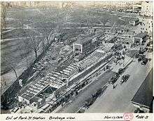
On March 23, 1912, the Cambridge Tunnel opened from Harvard Square to Park Street Under.[2] Park Street Under was built with two tracks with one side platform each and a center island platform, intended as a Spanish solution setup to speed boarding. Stairwells were added to the original platform level to connect to the lower level platforms. Unlike most other underground stations on the system (which were cut and cover construction with low ceilings), Park Street Under featured a spacious double-vaulted ceiling.
It was the first transfer station on the system to receive the "Under" postfix, rather than a separate name from the existing station. This represented a change in naming policy, and the first step towards easing wayfinding difficulty in the complex system.[4] North Station West (opened later in 1912), South Station Under (1916) and Scollay Under (1916) would later use this naming scheme; only Washington (1915) did not, as the southbound and northbound Main Line platforms there were already separately named Summer and Winter.
Overcrowding had been a problem at Park Street since the Main Line was routed through it, and did not improve when it reverted to streetcar-only operations. The problem worsened with the influx of passengers transferring at Park Street Under, as the only entrances to those platforms were narrow staircases through the streetcar level.[3] In preparation for the extension of the Cambridge Tunnel, the Boston Transit Commission ordered a major renovation. The streetcar platforms were substantially lengthened to the south, and the kiosk on the southbound platform was moved. The construction work began on August 7, 1914, and was completed on March 8, 1915.[3][5]
Construction of the extension begun on May 3, 1912; the Dorchester Tunnel opened to Washington on April 4, 1915, and in three more segments to South Station in 1916, Broadway in 1917, and Andrew Square in 1918.[2]
Later changes
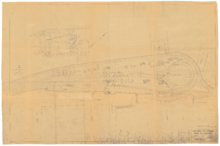
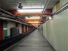
The stairways to the side platforms on the lower level were widened by 1922 to support increased passenger flow. A new staircase from the northbound streetcar platform to the lower island platform was also installed. These reduced the amount of room available on the north ends of the streetcar platforms, and boarding areas were moved south.[3] The Park Street Information Booth on the upper level, which soon became a Boston landmark, opened on September 15, 1923 and replaced an earlier kiosk in the same location.[5]
In 1936, in response to still-persistent overcrowding, a side platform was built adjacent to the outer northbound streetcar track. A new entrance connected to this platform was built on the east side of Park Street at Temple Place, with a passageway under Tremont Street. A second passage connected the new platform with the Cambridge Tunnel fare lobby opposite Park Street. The new platform moved the streetcar boarding area southbound for the second time. A new lighting system was also installed.[3] The project, funded by the Works Progress Administration, began on January 8, 1936, and was opened on December 5.[5]
In 1964, the outer loop track was removed. Instead, a new crossover was installed allowing southbound streetcars from the through track to reach either side of the southbound platform.[3] There have been proposals to reconnect this loop, to allow trains on the outer inbound track to be turned around at Park Street, but this has not been done because of the cost of structural reinforcements that would now be required. In 1967, as part of a general system rebranding by the newly formed MBTA, the subway lines were assigned colors. The streetcar system—then down to five lines, and soon four—became the Green Line, the Cambridge-Dorchester Line became the Red Line, and the Main Line El became the Orange Line.[2]
The late 1970s saw the first major renovations to the station in four decades. The 1936-built Temple Place entrance and passageway were closed in late 1976, and concession stands were removed in 1977. The modernization included new wall tiles, new lighting, rebuilt staircases, and upgrades to the faregate area on the southbound platform.[3] The Winter Street Concourse, an upper level of the Dorchester Tunnel between Park Street and Downtown Crossing, was cleared of offices and opened as a passenger connector in January 1979. It allows passengers to walk from the northbound Green Line side platform at Park Street to the southbound Orange Line platform at Downtown Crossing while inside fare control.[3][5]
Station layout
Park Street is a bi-level station, with the Green Line running on the upper level and the Red Line on the lower level. It is the only MBTA subway station with six tracks: tracks 1 to 4 are used by Green Line trains, while tracks 5 and 6 are served by the Red Line. The upper level has two island platforms and one side platform, while the lower level has one island platform and two side platforms.
| Ground | Street Level | Exit/Entrance |
| B1 Green Line platforms |
Mezzanine and Winter Street Concourse to Orange Line and Silver Line platforms | |
| Westbound | ← Green Line toward Cleveland Circle or Heath Street (Boylston) | |
| Island platform, doors will open on the left, right | ||
| Westbound | ← Green Line toward Boston College or Riverside (Boylston) | |
| Eastbound | → Green Line short turn → | |
| Island platform, doors will open on the left, right | ||
| Eastbound | → Green Line toward Government Center, North Station, or Lechmere (Government Center) → | |
| Side platform, doors will open on the right | ||
| B2 Red Line platforms |
Side platform, doors will open on the right | |
| Northbound | ← Red Line toward Alewife (Charles/MGH) | |
| Island platform, doors will open on the left | ||
| Southbound | → Red Line toward Ashmont or Braintree (Downtown Crossing) → | |
| Side platform, doors will open on the right | ||
Accessibility
Park Street station is partially wheelchair accessible, after renovations completed in 2004 and 2012. The Red Line on the lower level has both island and side platforms, a setup that theoretically allows implementation of the "Spanish solution" system of managing heavy passenger traffic flows. However, narrow stairways serving the center island platform impair full implementation of this system, since many impatient riders prefer to sprint up the wider side platform stairway to catch a Green Line transfer. Only the island platform of the Red Line level has elevator access.
New elevators from the surface to the westbound Green Line unpaid lobby and from the westbound Green Line platform to the Red Line island platform opened on December 21, 2012.[6]
The elevators are as follows:
- Boston Common (in a standalone kiosk, south of stairway kiosk to the westbound Green Line entrance) / Fare gate entrance to the Green Line westbound island platform
- Green Line westbound island platform (pictured) / Red Line island platform
- Red Line island platform / Confluence of the northern end of the Green Line northbound side platform and the Winter Street passageway to the Orange Line southbound
- Middle of the Green Line westbound center platform / Passageway between the Green Line platforms
- Middle of the Green Line northbound island platform / Passageway between the Green Line platforms
Bus connections
Although Park Street is not a major bus transfer point, it is served by two of the few MBTA Bus routes which run downtown. The 43 Ruggles Station - Park & Tremont Streets via Tremont Street route is a replacement for streetcar service that formerly ran to Park Street through the southern section of the Tremont Street Tunnel, while the 55 Jersey & Queensberry - Copley Square or Park & Tremont Street via Ipswich Street route provides local service to the Back Bay and Fenway-Kenmore areas.
Public art
There are several pieces of public art in the station. Benedictions by Ralph Helmick consists of two giant bronze hands mounted separately over the inbound and outbound Red Line tracks on the lower level of the station.[7] Celebration of the Underground by Lilli Ann K. Rosenberg is a large wall mosaic along the outer outbound (westbound) tracks at the Green Line level, which can be viewed from the outbound island platform. The mosaic commemorates the designation of the Tremont Street Subway, including Park Street station, as a National Historic Landmark.[8]
References
- 1 2 "Ridership and Service Statistics" (PDF) (14 ed.). Massachusetts Bay Transportation Authority. 2014. Retrieved 21 May 2014.
- 1 2 3 4 5 6 7 Belcher, Jonathan (22 March 2014). "Changes to Transit Service in the MBTA district" (PDF). NETransit. Retrieved 28 January 2015.
- 1 2 3 4 5 6 7 8 Chasson, George Jr. (1987). Lonto, Arthur J., ed. "Boston's Main Line El: The Formative Years 1879-1908". Headlights. Electric Railroader's Association. 49: 22–23.
- ↑ O'Regan, Gerry (2012). "MBTA Red Line". nycsubway.org. David Pirmann. Retrieved 27 January 2014.
- 1 2 3 4 Clarke, Bradley H. & Cummings, O.R. (1997). Tremont Street Subway: A Century of Public Service. Boston Street Railway Association. pp. 43, 49. ISBN 0938315048.
- ↑ Smith, Kelly (21 December 2012). "New elevators for America's first subway station". Massachusetts Bay Transportation Authority. Retrieved 22 December 2012.
- ↑ "On the Red Line" (PDF). Massachusetts Bay Transportation Authority. Retrieved 27 January 2015.
- ↑ "On the Green Line" (PDF). Massachusetts Bay Transportation Authority. Retrieved 27 January 2015.
External links
| Wikimedia Commons has media related to Park Street (MBTA station). |
- MBTA - Park Street
- Park Street entrance from Google Maps Street View
- West Street entrance from Google Maps Street View