Ravensbourne National Park
This article is about Ravensbourne National Park, Australia. For other places named Ravensbourne, see Ravensbourne.
| Ravensbourne National Park Queensland | |
|---|---|
|
IUCN category II (national park) | |
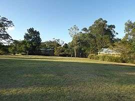
 Picnic area near Gus Beutel Lookout, 2014 | |
 Ravensbourne National Park | |
| Nearest town or city | Toowoomba |
| Coordinates | 27°21′24″S 152°12′06″E / 27.35667°S 152.20167°ECoordinates: 27°21′24″S 152°12′06″E / 27.35667°S 152.20167°E |
| Established | 1922 |
| Area | 4.40 km2 (1.70 sq mi) |
| Managing authorities | Queensland Parks and Wildlife Service |
| Website | Ravensbourne National Park |
| See also | Protected areas of Queensland |
Ravensbourne is a national park in Ravensbourne and Buaraba in South East Queensland, Australia, 33 km west of Esk. It is a small scenic park on the Great Dividing Range within the Lockyer Creek water catchment area and overlooking the Lockyer Valley. Small remnants of the rainforest and wet eucalypt forest that once covered this part of the Great Dividing Range are preserved in Ravensbourne National Park.[1] Red soils of the park's west and south-west support rainforest that includes eucalypt species as well as palms, vines and ferns. Sandy soils of the park's eastern section support open eucalypt forest. The park is situated in the water catchment areas of the Brisbane River and Lockyer Creek.[2]
Fauna
A total of four rare or threatened species have been recorded in the park.[2] More than 80 species of birds have been recorded in the park.[3]
See also
References
- ↑ "Ravensbourne National Park". totaltravel.com.au. Retrieved 5 September 2009.
- 1 2 "Ravensbourne National Park". WetlandInfo. Department of Environment and Heritage Protection. Retrieved 27 March 2016.
- ↑ "Ravensbourne National Park". Crows Nest Tourism. Retrieved 5 September 2009.
External links
![]() Media related to Ravensbourne National Park at Wikimedia Commons
Media related to Ravensbourne National Park at Wikimedia Commons