Rocky Mountain National Park Utility Area Historic District
|
Rocky Mountain National Park Utility Area Historic District | |
|
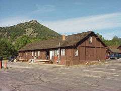
A warehouse in the district | |
  | |
| Nearest city | Estes Park, Colorado |
|---|---|
| Coordinates | 40°21′50″N 105°33′38″W / 40.36389°N 105.56056°WCoordinates: 40°21′50″N 105°33′38″W / 40.36389°N 105.56056°W |
| Built | 1923 |
| Architect | National Park Service; Taliesin Associated Architects,Ltd. |
| Architectural style | Other |
| MPS | Rocky Mountain National Park MRA (AD) |
| NRHP Reference # | 82001717 |
| Added to NRHP | March 18, 1982[1] |
The Rocky Mountain National Park Utility Area Historic District in Rocky Mountain National Park documents the early administrative core of the park. Beginning in 1920 and continuing into the 1930s, park service and administrative structures were built in the National Park Service Rustic style. Most buildings were built of logs under a policy of blending with the natural landscape. Later construction has respected the materials and scale of the area. Structures include McLaren Hall, designed by landscape architect W.G. Hill, a number of employee residences including the superintendent's residence, equipment sheds, garages and utility buildings. Many of the buildings built in the 1930s were built by Civilian Conservation Corps labor.[2] The Beaver Meadows Visitor Center is individually listed as a National Historic Landmark.[3]
See also
National Register of Historic Places listings in Larimer County, Colorado
References
- ↑ National Park Service (2008-04-15). "National Register Information System". National Register of Historic Places. National Park Service.
- ↑ "Utility Area HD McLaren Hall Annex". List of Classified Structures. National Park Service. 2009-01-11.
- ↑ Rodd L. Wheaton (August 22, 1975). National Register of Historic Places Inventory-Nomination: Rocky Mountain National Park Utility Area Historic District (pdf). National Park Service.

