Shire of Bowen
| Shire of Bowen Queensland | |||||||||||||
|---|---|---|---|---|---|---|---|---|---|---|---|---|---|
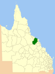
 Location within Queensland | |||||||||||||
| Population | 12,377 (2006 census)[1] | ||||||||||||
| • Density | 0.584251/km2 (1.51320/sq mi) | ||||||||||||
| Established | 1879 | ||||||||||||
| Area | 21,184.4 km2 (8,179.3 sq mi) | ||||||||||||
| Council seat | Bowen | ||||||||||||
| Region | North Queensland | ||||||||||||
 | |||||||||||||
The Shire of Bowen was a local government area in the North Queensland region of Queensland, Australia. The shire, administered from the town of Bowen, covered an area of 21,184.4 square kilometres (8,179.3 sq mi), and existed as a local government entity from 1879 until 2008, when it amalgamated with the Shire of Whitsunday to form the Whitsunday Region.
The Shire's economy was based on tropical agriculture, fishing, tourism and coal mining.
History
The Shire of Bowen had its origins in two entities:
- the Borough of Bowen which was constituted as a municipality on 7 August 1863 under the Municipalities Act 1858 to provide local government within the urban area of Bowen
- the Wangaratta Division which was created on 11 November 1879 as one of 74 divisions around Queensland under the Divisional Boards Act 1879 to provide local government in the rural areas surrounding Bowen[2]
With the passage of the Local Authorities Act 1902, the Borough of Bowen became the Town of Bowen and Wangaratta Division became the Shire of Wangaratta on 31 March 1903.[2][3][4]
On 2 April 1960, the Town of Bowen was abolished, and merged into the Shire of Wangaratta, which was renamed Shire of Bowen.[3][4][5][6]
On 15 March 2008, under the Local Government (Reform Implementation) Act 2007 passed by the Parliament of Queensland on 10 August 2007, the Shire of Bowen merged with the Shire of Whitsunday to form the Whitsunday Region.[6][7]
Towns and localities
The Shire of Bowen included the following settlements:
- Bowen
- Collinsville
- Binbee
- Bogie
- Brisk Bay
- Gumlu
- Guthalungra
- Inveroona
- Merinda
- Mount Coolon
- Mount Wyatt
- Newlands
- Queens Beach
- Scottville
- Springlands
Chairmen and mayors
Mayor of Borough/Town of Bowen
Population
| Year | Population |
|---|---|
| 1933 | 7,543 |
| 1947 | 8,083 |
| 1954 | 8,518 |
| 1961 | 9,491 |
| 1966 | 9,342 |
| 1971 | 10,231 |
| 1976 | 11,292 |
| 1981 | 13,645 |
| 1986 | 14,364 |
| 1991 | 14,161 |
| 1996 | 14,411 |
| 2001 | 13,698 |
| 2006 | 14,625 |
References
- ↑ Australian Bureau of Statistics (25 October 2007). "Bowen (S) (Local Government Area)". 2006 Census QuickStats. Retrieved 2008-03-18.
- 1 2 "Agency ID11121, Wangaratta Divisional Board". Queensland State Archives. Retrieved 10 September 2013.
- 1 2 "Agency ID11123, Bowen Town Council". Queensland State Archives. Retrieved 10 September 2013.
- 1 2 "Agency ID11122, Wangaratta Shire Council". Queensland State Archives. Retrieved 10 September 2013.
- ↑ "Order in Council". Queensland Government Gazette. 4 February 1960. p. 203:477-478.
- 1 2 "Agency ID349, Bowen Shire Council". Queensland State Archives. Retrieved 10 September 2013.
- ↑ "Agency ID11036, Whitsunday Regional Council". Queensland State Archives. Retrieved 10 September 2013.
- ↑ "LICENSING AUTHORITIES.". Townsville Daily Bulletin. Qld.: National Library of Australia. 4 April 1908. p. 3. Retrieved 19 May 2014.
- ↑ Pugh, Theophilus Parsons (1927). Pugh's Almanac for 1927. Retrieved 13 June 2014.
- ↑ Australian History Publishing Co (1936), Queensland and Queenslanders : incorporating 'Prominent Queenslanders', Australian History Publishing Co, p. 168, retrieved 1 October 2015 — available online
External links
- Official website at the Wayback Machine (archived March 15, 2008)
