Shire of Walloon
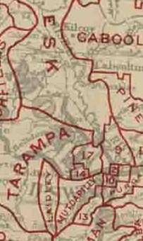
The Shire of Walloon is a former local government area in the south-east of Queensland, Australia. Its administrative centre was in the town of Marburg.[1]
History
On 11 November 1879, the Walloon Division was created as one of 74 divisions within Queensland under the Divisional Boards Act 1879 with a population of 3749.[2][3]
With the passage of the Local Authorities Act 1902, the Walloon Division became the Shire of Walloon on 31 March 1903.[3][4]
On 19 January 1912, under the Local Authorities Act 1902, that part of the Shire of Walloon was excised to create the Shire of Lowood, centred on the town of Lowood.[5]
The Greater Ipswich Scheme
On 13 October 1916, a rationalisation of the local government areas in and around Ipswich was implemented. It involved the abolition of five shires:[6]
resulting in:
- a new Shire of Ipswich by amalgamating part of the Shire of Brassall, part of the Shire of Bundanba, part of the Shire of Walloon and all of the Shire of Purga[7]
- an enlarged Shire of Rosewood by including part of the Shire of Walloon
- an enlarged City of Ipswich by including part of the Shire of Brassall and part of the Shire of Bundanba[8]
- an enlarged Shire of Esk by including all of the Shire of Lowood[5]
Chairmen
References
- ↑ "Marburg, Haigslea, Ironbark". Queensland Places. Centre for the Government of Queensland, University of Queensland. Retrieved 3 January 2013.
- ↑ "Proclamation [Walloon Division]". Queensland Government Gazette. 11 November 1879. p. 25:991.
- 1 2 "Agency ID1925, Walloon Divisional Board". Queensland State Archives. Retrieved 12 September 2013.
- ↑ "Agency ID1926, Walloon Shire Council". Queensland State Archives. Retrieved 12 September 2013.
- 1 2 "Agency ID11326, Lowood Shire Council". Queensland State Archives. Retrieved 12 September 2013.
- ↑ "Greater Ipswich Scheme.". The Brisbane Courier. National Library of Australia. 14 October 1916. p. 4. Retrieved 12 September 2013.
- ↑ "Agency ID995, Ipswich Shire Council". Queensland State Archives. Retrieved 12 September 2013.
- ↑ "Agency ID992, Ipswich City Council". Queensland State Archives. Retrieved 12 September 2013.
- ↑ "Advertising.". Queensland Times, Ipswich Herald & General Advertiser. National Library of Australia. 1 June 1880. p. 2. Retrieved 28 December 2013.
- ↑ Consolidated Index to Queensland Government Gazette 1859-1919. Queensland Family History Society. 2004. ISBN 1 876613 79 3.
External links
- "Walloon". Queensland Places. Centre for the Government of Queensland, University of Queensland.
Coordinates: 27°33′40″S 152°35′20″E / 27.561°S 152.589°E