Mong Kok East Station
Mong Kok East 旺角東 | |||||||||||||
|---|---|---|---|---|---|---|---|---|---|---|---|---|---|
| MTR rapid transit station | |||||||||||||
.JPG) Station exterior (from Yim Po Fong Street) | |||||||||||||
| Chinese name | |||||||||||||
| Traditional Chinese | 旺角東 | ||||||||||||
| Simplified Chinese | 旺角东 | ||||||||||||
| Literal meaning | Flourishing Corner East | ||||||||||||
| |||||||||||||
| General information | |||||||||||||
| Location |
Luen Wan Street/Argyle Street, Mong Kok Yau Tsim Mong District, Hong Kong | ||||||||||||
| Coordinates | 22°19′20″N 114°10′22″E / 22.3222°N 114.1728°ECoordinates: 22°19′20″N 114°10′22″E / 22.3222°N 114.1728°E | ||||||||||||
| Owned by | Kowloon–Canton Railway Corporation | ||||||||||||
| Operated by | MTR Corporation | ||||||||||||
| Line(s) | |||||||||||||
| Platforms | 3 (1 side platform and 1 island platform) | ||||||||||||
| Connections | Bus, public light bus | ||||||||||||
| Construction | |||||||||||||
| Structure type | On embankment | ||||||||||||
| Platform levels | 1 | ||||||||||||
| Disabled access | Yes | ||||||||||||
| Other information | |||||||||||||
| Station code | MKK | ||||||||||||
| History | |||||||||||||
| Opened |
| ||||||||||||
| Rebuilt | 4 May 1982 | ||||||||||||
| Electrified | 1983 | ||||||||||||
| Previous names | Mong Kok, Yaumati | ||||||||||||
| Services | |||||||||||||
| |||||||||||||
| Location | |||||||||||||
|
Mong Kok East Location within the MTR system | |||||||||||||
Mong Kok East (Chinese: 旺角東) – formerly Yaumati (油麻地) and Mong Kok (旺角) – is a station on Hong Kong's East Rail Line. Only out-of-system interchange is available with Kwun Tong Line and Tsuen Wan Line at Mong Kok Station via a footbridge. The station is connected to Grand Century Place, a large shopping mall.
Although the station is in the same region and quite close to Mong Kok Station, the fares are quite different from each other.
History
The station, initially named Yaumati, was constructed on 1 October 1910 to cope with the opening of the British Section of Kowloon-Canton Railway.[1] The station was later renamed as Mong Kok. In 1983, the station was rebuilt. A temporary station was in use just to the south (towards Hung Hom) during reconstruction. After the takeover of KCR operations by the MTR Corporation on 2 December 2007, the station was renamed to Mong Kok East. Following the MTR-KCR merger, this station shared a name with the separate Mong Kok Station on the Tsuen Wan and Kwun Tong lines.
Station layout
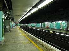
Platform 1 is the terminus platform for some southbound trains during peak hours. The platforms are curved and the platform gap is relatively large compared to other MTR stations.
| - | Overlaying properties | Grand Century Place |
| M | Mezzanine | Staff only area, MTRShop (MX Fastfood) |
| C | Concourse | Exits, a transport interchange Customer Service Centres, toilets shops, vending machines, ATMs |
| P Platforms |
Platform 1 | East Rail Line towards Lo Wu or Lok Ma Chau (Kowloon Tong) → East Rail Line termination platform (some rush-hour trips) → |
| Island platform, doors will open on the left or right | ||
| Platform 2 | East Rail Line towards Lo Wu or Lok Ma Chau (Kowloon Tong) → | |
| Platform 3 | ← East Rail Line towards Hung Hom (Terminus) | |
| Side platform, doors will open on the left | ||
Entrances/exits
.jpg)
- A: Government Offices Carpark
- B: Mongkok Government Offices
- C: Sai Yee Street
- D: Grand Century Place[3]
Nearby landmarks
Transport connections
Minibus RoutesTo Cosmopolitan Estate:
To Metro Harbour View:
To Park Avenue:
|
Bus RoutesTo Po Lam:
To Tsing Yi Estate:
To Siu Hong Court:
To Tuen Mun (Leung King Estate):
To Tuen Mun Pier:
|
References
- ↑ Hong Kong transport timeline
- ↑ "Mong Kok East Station layout" (PDF). MTR Corporation. Retrieved 15 February 2015.
- ↑ "Mong Kok East Station street map" (PDF). MTR Corporation. Retrieved 15 February 2015.
| Wikimedia Commons has media related to Mong Kok East Station. |
