Ulaangom
| Ulaangom Улаангом ᠤᠯᠠᠭᠠᠩᠭ᠋ᠣᠮ | |
|---|---|
| District | |
| Ulaangom District Улаангом сум ᠤᠯᠠᠭᠠᠩᠭ᠋ᠣᠮᠰᠤᠮᠤ | |
|
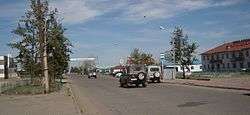
Central Ulaangom | |
 Ulaangom Location in Mongolia | |
| Coordinates: 49°59′11″N 92°04′19″E / 49.98639°N 92.07194°E | |
| Country |
|
| Province | Uvs Province |
| Founded | 1686 |
| Elevation | 931 m (3,054 ft) |
| Population (2012) | |
| • Total | 25'098 |
Ulaangom (Mongolian: Улаангом, Red Valley) is the capital of Uvs Province in Mongolia. It is located on the slopes of the Kharkhiraa mountain, 26 kilometres (16 mi) southwest from the lake Uvs Nuur shore and 120 kilometres or 70 miles south from the Russian border.
Description
The city has a population of 26,319 (2000 census), 23,000 (2006 est.[1]), 22,300 (end of 2008 est.[2]) or 28.9% of the total population of Uvs aimag. It is divided into two suburban areas named Chandmani "Чандмань" and Uliasny Khev "Улиасны Хэв".
A Consulate of Tuva Republic of Russia is located in Ulaangom, and a Representative Office of Uvs Province in Kyzyl, the capital of Tuva.
Culture
The city has monuments from the communist era, such as a monument of Yumjaagiin Tsedenbal, who was born in Uvs province and led the country for more than 40 years, in front of the Provincial Government Building. There are many educational and cultural organizations and institutions in the city. There is a branch of a university, a vocational college and 5 secondary schools.
History
Ulaangom is believed to be founded in 1686. The foundation of the Ulaangom Monastery was erected in 1871 as Dechinravjaa Monastery. Historical evidence indicates that there were grain plantations in operation in late 17th century in the area of Ulaangom.
Transportation
Ulaangom is connected to the Russian border by Highway, and imports its electricity from the Russian Federation. The old airport is no longer in service. New Ulaangom Airport is called Deglii Tsagaan and it is situated north of the city. The new runway and terminal were completed in June 2011 and the first jetliner of Eznis Airways landed on June 26, 2011 from Ulaanbaatar. Eznis Airways also runs flights between Ulaanbaatar, Ulaangom, and Ölgii. Aero Mongolia runs regular scheduled flight from Ulaanbaatar.
Climate
Ulaangom experiences a cold semi-arid climate (Köppen BSk) with long, dry, very cold winters and short, warm summers. Precipitation is very low, with an annual average of 130 millimetres or 5.12 inches. Owing to its location in a deep valley near the center of the Siberian High, Ulaangom is subject to temperature inversions reaching up to 13.0 °C or 23.4 °F colder than middle and upper mountain slopes. It is thus one of the coldest places in Mongolia[3] despite lying at a lower altitude than most of the country. Temperatures can reach −45 °C (−49 °F) or lower in the winter and 35 °C (95 °F) or more in the summer.
| Climate data for Ulaangom | |||||||||||||
|---|---|---|---|---|---|---|---|---|---|---|---|---|---|
| Month | Jan | Feb | Mar | Apr | May | Jun | Jul | Aug | Sep | Oct | Nov | Dec | Year |
| Record high °C (°F) | −12.0 (10.4) |
−6.2 (20.8) |
8.7 (47.7) |
28.0 (82.4) |
35.9 (96.6) |
33.9 (93) |
33.7 (92.7) |
36.4 (97.5) |
30.0 (86) |
24.6 (76.3) |
8.2 (46.8) |
−0.5 (31.1) |
36.4 (97.5) |
| Average high °C (°F) | −26.0 (−14.8) |
−23.4 (−10.1) |
−11.6 (11.1) |
6.5 (43.7) |
19.0 (66.2) |
24.5 (76.1) |
25.4 (77.7) |
23.3 (73.9) |
17.3 (63.1) |
7.2 (45) |
−5.8 (21.6) |
−21.2 (−6.2) |
2.93 (37.28) |
| Daily mean °C (°F) | −32.1 (−25.8) |
−29.8 (−21.6) |
−18.5 (−1.3) |
0.2 (32.4) |
11.4 (52.5) |
17.5 (63.5) |
18.9 (66) |
16.6 (61.9) |
10.0 (50) |
0.4 (32.7) |
−10.5 (13.1) |
−25.5 (−13.9) |
−3.45 (25.79) |
| Average low °C (°F) | −36.6 (−33.9) |
−35.4 (−31.7) |
−24.9 (−12.8) |
−6.0 (21.2) |
3.7 (38.7) |
10.1 (50.2) |
12.2 (54) |
9.7 (49.5) |
3.3 (37.9) |
−5.4 (22.3) |
−15.6 (3.9) |
−30.6 (−23.1) |
−9.62 (14.68) |
| Record low °C (°F) | −49.6 (−57.3) |
−47.7 (−53.9) |
−47.7 (−53.9) |
−24.7 (−12.5) |
−8.3 (17.1) |
−3.1 (26.4) |
0.4 (32.7) |
0.2 (32.4) |
−8.7 (16.3) |
−22.5 (−8.5) |
−35.3 (−31.5) |
−45.2 (−49.4) |
−49.6 (−57.3) |
| Average precipitation mm (inches) | 1.8 (0.071) |
1.8 (0.071) |
3.4 (0.134) |
3.9 (0.154) |
6.3 (0.248) |
26.2 (1.031) |
35.0 (1.378) |
22.8 (0.898) |
13.4 (0.528) |
4.6 (0.181) |
6.8 (0.268) |
4.0 (0.157) |
130 (5.119) |
| Average precipitation days (≥ 1.0 mm) | 0.5 | 0.6 | 1.2 | 1.1 | 1.5 | 4.4 | 7.2 | 4.0 | 2.4 | 1.0 | 1.8 | 1.0 | 26.7 |
| Mean monthly sunshine hours | 135.0 | 158.4 | 233.9 | 260.4 | 313.4 | 318.9 | 307.4 | 297.2 | 250.4 | 195.9 | 100.5 | 103.6 | 2,675 |
| Source: NOAA (1961-1990) [4] | |||||||||||||
Coordinates: 49°59′N 92°04′E / 49.983°N 92.067°E
References
| Wikivoyage has a travel guide for Ulaangom. |
- ↑ Ministry of Health of Mongolia. National Center for Health Development. Health Indicators 2006
- ↑ Uvs Aimag Statistical Office.2008 Annual Report
- ↑ Bayasgalan Gerelchuluun and Ahn Joong-Bae; ‘Air temperature distribution over Mongolia using dynamical downscaling and statistical correction’, in International Journal of Climatology; 34: 2464 – 2476 (2014)
- ↑ "Ulaangom Climate Normals 1963-1990". National Oceanic and Atmospheric Administration. Retrieved January 12, 2012.

