| NM# |
Monument name |
Description |
Image |
Townland |
Location
|
|---|
| 56 | Annagh | Church | _looking_Northeast.JPG) | Annagh |
52°14′55″N 9°45′17″W / 52.248522°N 9.754818°W / 52.248522; -9.754818 |
| 430 | Ardcanaght Stones | Ogham Stones | | Ardcanaght |
52°10′10″N 9°43′35″W / 52.169473°N 9.726435°W / 52.169473; -9.726435 |
| 54 | Ardfert Cathedral | Cathedral & 2 Churches |  | Ardfert |
52°19′44″N 9°46′54″W / 52.328801°N 9.781773°W / 52.328801; -9.781773 |
| 358 | Ardfert Abbey | Friary (Franciscan) |  | Ardfert |
52°19′49″N 9°46′26″W / 52.330294°N 9.773911°W / 52.330294; -9.773911 |
| 221 | Arraglen | Ogham Stone | | Arraglen (Corkaguiney Barony) |
52°11′12″N 10°20′28″W / 52.186673°N 10.341102°W / 52.186673; -10.341102 |
| 355 | Gallaunmore | Standing stone | | Ballineetig |
52°08′21″N 10°13′22″W / 52.139254°N 10.222848°W / 52.139254; -10.222848 |
| 221 | Ballinknockane | Burial ground & possible church | | Ballinknockane (Kilgobban civil parish) |
52°14′02″N 10°17′49″W / 52.233905°N 10.297032°W / 52.233905; -10.297032 |
| 221 | Ballinknockane | Hut sites | | Ballinknockane (Kilquane civil parish) |
|
| 221 | Ballinknockane | Hut site & souterrain | | Ballinknockane (Kilquane civil parish) |
|
| 168 | Ballinskelligs Abbey | Priory (Augustinian) | 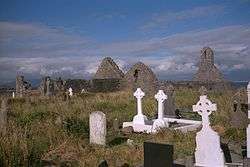 | Ballinskelligs |
51°48′55″N 10°16′18″W / 51.815318°N 10.271774°W / 51.815318; -10.271774 |
| 64 | Ballintaggart | Ogham Stones | .png) | Ballintaggart |
52°07′40″N 10°14′35″W / 52.127783°N 10.243178°W / 52.127783; -10.243178 |
| 221 | Ballybowler North | Ogham Stone | | Ballybowler North |
|
| 364 | Ballymalis Castle | Castle | _-_geograph.org.uk_-_1392760.jpg) | Ballymalis |
52°05′05″N 9°41′33″W / 52.084602°N 9.692596°W / 52.084602; -9.692596 |
| 62 | Teampall Geal (St. Manchan's Oratory) | Early Medieval Ecclesiastical Site & ogham stone | | Ballymorereagh |
52°09′16″N 10°19′53″W / 52.154517°N 10.331273°W / 52.154517; -10.331273 |
| 221 | Cathair na BhFionnúrach | Stone fort, huts & souterrain | | Ballynavenooragh |
52°13′34″N 10°17′53″W / 52.226192°N 10.297974°W / 52.226192; -10.297974 |
| 221 | Ballynavenooragh | Stone fort & hut | | Ballynavenooragh |
52°13′38″N 10°17′48″W / 52.227350°N 10.296693°W / 52.227350; -10.296693 |
| 221 | Cathair na gCat | Cashel & Ogham Stone | | Ballywiheen |
52°09′22″N 10°24′27″W / 52.156188°N 10.407492°W / 52.156188; -10.407492 |
| 221 | Ballywiheen | Early Medieval Ecclesiastical Site |  | Ballywiheen |
52°09′32″N 10°24′25″W / 52.158809°N 10.406990°W / 52.158809; -10.406990 |
| 380, 492 | Beenbane | Calluragh, hut sites, cross slab, enclosure, souterrain, cross, standing stones | | Beenbane |
51°49′55″N 10°09′25″W / 51.831927°N 10.156948°W / 51.831927; -10.156948 |
| 500 | Beginish house | Stone-built house |  | Beginish |
51°56′20″N 10°17′24″W / 51.938991°N 10.289963°W / 51.938991; -10.289963 |
| 184 | Caherconree Fort | Promontory Fort (Inland) | 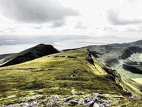 | Caherconree |
52°11′51″N 9°51′47″W / 52.197367°N 9.863012°W / 52.197367; -9.863012 |
| 221 | Caherdorgan North | Cashel | | Caherdorgan North |
52°10′45″N 10°20′22″W / 52.179233°N 10.339492°W / 52.179233; -10.339492 |
| 221 | The Chancellor's House | Building - medieval | %2C_The_Chancellor's_House_-_geograph.org.uk_-_275343.jpg) | Caherdorgan North |
52°10′54″N 10°20′18″W / 52.181803°N 10.338227°W / 52.181803; -10.338227 |
| 238 | Callanafersy (Lisgortnageragh) | Ringfort | | Callanafersy West |
52°08′13″N 9°46′28″W / 52.136969°N 9.774545°W / 52.136969; -9.774545 |
| 249 | Carrigafoyle Castle | Castle |  | Ballylongford |
52°34′12″N 9°29′39″W / 52.570048°N 9.494181°W / 52.570048; -9.494181 |
| 59 | Church Island (Valentia Harbour) | Early Medieval Ecclesiastical Site | | Valentia Harbour |
51°56′16″N 10°16′58″W / 51.937757°N 10.282833°W / 51.937757; -10.282833 |
| 60 | Church Island (Lough Currane) | Early Medieval Ecclesiastical Site | 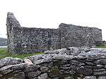 | Lough Currane |
51°50′07″N 10°07′49″W / 51.83516°N 10.1304°W / 51.83516; -10.1304 |
| 228 | Cloghanecarhan | Ringfort & Ogham Stone | | Cloghanecarhan |
51°53′18″N 10°11′02″W / 51.888380°N 10.183974°W / 51.888380; -10.183974 |
| 385 | Dunloe | Ogham Stones | .jpg) | Coolmagort |
52°03′36″N 9°38′05″W / 52.059967°N 9.634751°W / 52.059967; -9.634751 |
| 346 | Darrynane Beg | Ogham Stone | | Derrynane |
51°45′51″N 10°07′19″W / 51.764121°N 10.121920°W / 51.764121; -10.121920 |
| 221 | Doonmore | Promontory Fort |  | Doonsheane |
52°07′07″N 10°13′19″W / 52.118696°N 10.221967°W / 52.118696; -10.221967 |
| 221 | Emlagh East | Ogham Stone | | Emlagh East (Dingle civil parish) |
52°07′54″N 10°13′00″W / 52.131659°N 10.216570°W / 52.131659; -10.216570 |
| 391 | Emlagh East | Cashel | | Emlagh East (Dingle civil parish) |
52°08′04″N 10°13′32″W / 52.134521°N 10.225647°W / 52.134521; -10.225647 |
| 177 | Dunbeg Fort | Promontory Fort |  | Fahan |
52°06′12″N 10°24′31″W / 52.103408°N 10.408541°W / 52.103408; -10.408541 |
| 65 | Gallarus Castle | Castle | 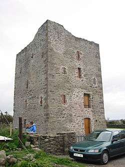 | Baile na nGall |
52°10′33″N 10°21′21″W / 52.175824°N 10.355942°W / 52.175824; -10.355942 |
| 66 | Gallarus Oratory | Early Medieval Ecclesiastical Site |  | Baile na nGall |
52°10′22″N 10°21′00″W / 52.172695°N 10.349936°W / 52.172695; -10.349936 |
| 64 | Garfinny | Cemetery | | Garfinny |
52°08′53″N 10°14′03″W / 52.147965°N 10.234200°W / 52.147965; -10.234200 |
| 612 | Garfinny | Bridge |  | Garfinny & Flemingstown |
52°09′00″N 10°13′38″W / 52.149939°N 10.227143°W / 52.149939; -10.227143 |
| 156 | Cathair Sayer | Clochaun | | Glanfahan |
|
| 156 | Cathair Martín | Clochaun | | Glanfahan |
52°06′07″N 10°25′29″W / 52.101993°N 10.424610°W / 52.101993; -10.424610 |
| 156 | Cathair Murphy | Clochaun | | Glanfahan |
|
| 156 | Cathair Síleoid | Clochán | | Glanfahan |
|
| 156 | Caher Conor | Cashel | | Glanfahan |
52°06′06″N 10°25′17″W / 52.101705°N 10.421369°W / 52.101705; -10.421369 |
| 221 | Glin North | Clochán & stone fort | | Glin North |
52°10′52″N 10°16′53″W / 52.181148°N 10.281366°W / 52.181148; -10.281366 |
| 221 | Glin North | Cashel | | Glin North |
52°10′49″N 10°17′09″W / 52.180344°N 10.285700°W / 52.180344; -10.285700 |
| 63 | Rínn an Chaisleáin | Church site | | Great Blasket Island |
52°05′40″N 10°32′26″W / 52.094469°N 10.540438°W / 52.094469; -10.540438 |
| 61 | Skellig Michael | Early Medieval Ecclesiastical Site | 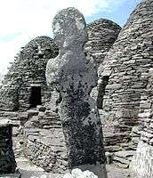 | Great Skellig |
51°46′20″N 10°32′19″W / 51.772187°N 10.538701°W / 51.772187; -10.538701 |
| 67 | Illauntannig | Early Medieval Ecclesiastical Site | | Illauntannig |
52°19′34″N 10°01′12″W / 52.326209°N 10.019893°W / 52.326209; -10.019893 |
| 63 | Inishtooskert | Early Medieval Ecclesiastical Site |  | Inishtooskert |
52°04′55″N 10°34′05″W / 52.082043°N 10.568069°W / 52.082043; -10.568069 |
| 63 | Inishvickillane | Early Medieval Ecclesiastical Site | | Inishvickillane |
52°02′39″N 10°36′31″W / 52.044036°N 10.608539°W / 52.044036; -10.608539 |
| 183 | Innisfallen Abbey | Church, Oratory & Abbey (Benedictine) |  | Innisfallen Island |
52°02′48″N 9°33′15″W / 52.046577°N 9.554222°W / 52.046577; -9.554222 |
| 329 | Kilcoolaght East ogham stones | Ogham Stones | | Kilcoolaght East |
52°04′26″N 9°44′46″W / 52.073977°N 9.745985°W / 52.073977; -9.745985 |
| 593 | Killelton | Church |  | Killelton |
52°13′41″N 9°52′26″W / 52.228188°N 9.873757°W / 52.228188; -9.873757 |
| 65 | Kilmalkedar | Early Medieval Ecclesiastical Site |  | Kilmalkedar |
52°11′06″N 10°20′11″W / 52.184913°N 10.336476°W / 52.184913; -10.336476 |
| 221 | Keelers' Stone | Bullaun Stone | | Kilmalkedar |
52°11′08″N 10°20′18″W / 52.185523°N 10.338254°W / 52.185523; -10.338254 |
| 221 | St. Brendan's Oratory | Church | | Kilmalkedar |
52°11′05″N 10°20′11″W / 52.184798°N 10.336304°W / 52.184798; -10.336304 |
| 227 | Cahergall | Cashel |  | Kimego West |
51°57′21″N 10°15′28″W / 51.955903°N 10.257801°W / 51.955903; -10.257801 |
| 414 | Leacanabuaile | Cashel | | Kimego West |
51°57′30″N 10°15′43″W / 51.958234°N 10.261858°W / 51.958234; -10.261858 |
| 258 | Lislaughtin Abbey | Friary (Franciscan) |  | Lislaughtin |
52°33′27″N 9°28′12″W / 52.557472°N 9.470057°W / 52.557472; -9.470057 |
| 260 | Listowel Castle | Castle | 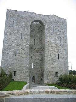 | Listowel |
52°26′33″N 9°39′00″W / 52.442473°N 9.64999°W / 52.442473; -9.64999 |
| 611 | Loher | Cashel |  | Loher |
51°47′10″N 10°09′56″W / 51.78604°N 10.16558°W / 51.78604; -10.16558 |
| 221 | Maumanorig | Early Medieval Ecclesiastical Site | | Maumanorig |
52°08′38″N 10°21′31″W / 52.143812°N 10.358662°W / 52.143812; -10.358662 |
| 311 | Muckross Abbey | Friary (Franciscan) | 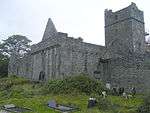 | Killarney National Park |
52°01′34″N 9°29′42″W / 52.026206°N 9.494901°W / 52.026206; -9.494901 |
| 53 | Aghadoe | Early Medieval Ecclesiastical Site | 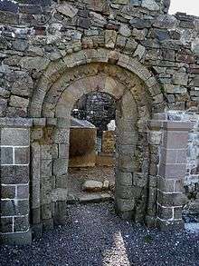 | Parkavonear |
52°04′36″N 9°33′16″W / 52.076745°N 9.554511°W / 52.076745; -9.554511 |
| 236 | Parkavonear Castle | Castle | 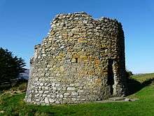 | Parkavonear |
52°04′33″N 9°33′18″W / 52.075938°N 9.555020°W / 52.075938; -9.555020 |
| 10001 | Illaunloughan | Early Medieval Ecclesiastical Site | | Portmagee |
51°53′11″N 10°22′25″W / 51.886476°N 10.373579°W / 51.886476; -10.373579 |
| 221 | Rahinnane Castle | Castle, Ringfort and Souterrain |  | Ventry |
52°08′35″N 10°22′59″W / 52.143153°N 10.383186°W / 52.143153; -10.383186 |
| 57 | Ratass | Church & Ogham Stone |  | Ratass |
52°16′01″N 9°40′55″W / 52.267011°N 9.681834°W / 52.267011; -9.681834 |
| 55 | Rattoo | Early Medieval Ecclesiastical Site | 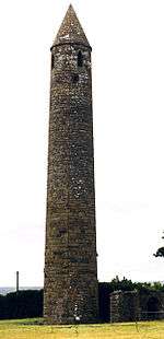 | Rattoo |
52°26′33″N 9°39′00″W / 52.442473°N 9.64999°W / 52.442473; -9.64999 |
| 519 | Reask | Early Medieval Ecclesiastical Site | 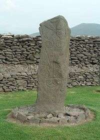 | Reask |
52°10′03″N 10°23′16″W / 52.167374°N 10.387698°W / 52.167374; -10.387698 |
| 221 | Reenconnell | Early Medieval Ecclesiastical Site | | Reenconnell |
52°11′07″N 10°18′10″W / 52.185371°N 10.302805°W / 52.185371; -10.302805 |
| 534 | Ross Castle | Castle | 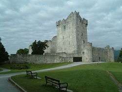 | Ross Island |
52°02′29″N 9°31′54″W / 52.041345°N 9.531683°W / 52.041345; -9.531683 |
| 221 | Dún an Óir (Fort del Oro) | Promontory Fort |  | Smerwick |
52°11′27″N 10°24′52″W / 52.190926°N 10.414348°W / 52.190926; -10.414348 |
| 143 | Staigue | Cashel | 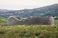 | Sneem |
51°48′18″N 10°00′56″W / 51.805033°N 10.015565°W / 51.805033; -10.015565 |
| 303 | Tonaknock Cross | Cross | | Tonaknock |
52°22′59″N 9°41′54″W / 52.383012°N 9.698287°W / 52.383012; -9.698287 |
| 295 | Tullygarran ogham stones | Two Ogham Stones | | Tullygarran |
52°16′33″N 9°38′33″W / 52.275833°N 9.642500°W / 52.275833; -9.642500 |