| NM# |
Monument name |
Description |
Image |
Townland |
Location
|
|---|
| 103 | Moyne Abbey | Friary (Franciscan) | 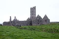 | Abbeylands |
54°12′08″N 9°10′37″E / 54.202234°N 9.177070°E / 54.202234; 9.177070 |
| 96 | Aghagower Round Tower | Round Tower & Church | 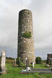 | Aghagower |
53°45′51″N 9°27′54″W / 53.764136°N 9.46491°W / 53.764136; -9.46491 |
| 243 | Aghalard Castle | Castle | | Aghalahard |
53°33′22″N 9°17′56″W / 53.556042°N 9.298899°W / 53.556042; -9.298899 |
| 403 | Balla Round Tower | Round Tower | 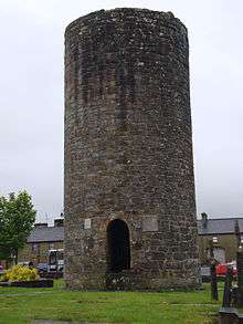 | Balla |
53°48′18″N 9°07′53″W / 53.805042°N 9.131478°W / 53.805042; -9.131478 |
| 145 | Ballina Portal Tomb (Dolmen of the Four Maols) | Portal Tomb | | Ballina |
54°06′25″N 9°09′57″W / 54.107036°N 9.165794°W / 54.107036; -9.165794 |
| 501 | Ballintubber Abbey | Priory (Augustinian) | 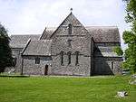 | Ballintubber |
53°45′23″N 9°16′58″W / 53.756382°N 9.282874°W / 53.756382; -9.282874 |
| 325 | Ballylahan Castle | Castle | 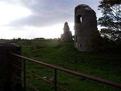 | Ballylahan |
53°56′05″N 9°06′18″W / 53.9346°N 9.105°W / 53.9346; -9.105 |
| 251 | Ballymacgibbon Cairn | Cairn | | Ballymacgibbon North |
53°32′32″N 9°14′14″W / 53.542213°N 9.237102°W / 53.542213; -9.237102 |
| 561 | Barnacahoge Cashel | Cashel | | Barnacahoge |
53°54′20″N 8°51′23″W / 53.905452°N 8.856397°W / 53.905452; -8.856397 |
| 530 | Boheh Stone | Rock Art | | Boheh |
53°44′51″N 9°33′14″W / 53.747497°N 9.553945°W / 53.747497; -9.553945 |
| 415 | Breastagh Ogham Stone | Ogham Stone | .jpg) | Breastagh |
54°14′47″N 9°15′12″W / 54.246420°N 9.253433°W / 54.246420; -9.253433 |
| 244 | Caherduff Castle | Castle | | Caherduff |
53°33′08″N 9°14′41″W / 53.552185°N 9.244741°W / 53.552185; -9.244741 |
| 631 | Carbad More | Ringfort | | Carbad More |
54°14′10″N 9°15′27″W / 54.236138°N 9.257463°W / 54.236138; -9.257463 |
| 246 | Eochy's Cairn | Cairn | | Carn (Ballinchalla) |
53°35′19″N 9°15′48″W / 53.588504°N 9.263412°W / 53.588504; -9.263412 |
| 458 | Carrickkildavnet Castle | Castle | 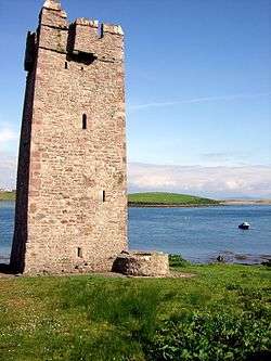 | Carrickkildavnet |
53°52′51″N 9°56′46″W / 53.88089°N 9.94607°W / 53.88089; -9.94607 |
| 293 | Carrowcastle Wedge Tomb | Wedge Tomb | | Carrowcastle |
54°05′41″N 9°04′45″W / 54.094811°N 9.079115°W / 54.094811; -9.079115 |
| 293 | Carrowcrom Tomb | Megalithic Tomb | | Carrowcrom |
54°05′24″N 9°02′52″W / 54.089964°N 9.047911°W / 54.089964; -9.047911 |
| 293 | Carrowcrom Stone (Corrower Ogham Stone) | Ogham Stone | | Carrowcrom |
54°04′20″N 9°04′42″W / 54.072296°N 9.078286°W / 54.072296; -9.078286 |
| 196 | Murrisk Abbey | Friary (Augustinian) |  | Murrisk |
53°46′55″N 9°38′22″W / 53.781948°N 9.639548°W / 53.781948; -9.639548 |
| 235 | Burrishoole Abbey | Friary (Dominican) | 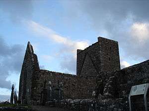 | Newport |
53°53′56″N 9°34′21″W / 53.898801°N 9.572522°W / 53.898801; -9.572522 |
| 483 | Cashel Cairn | Cairn / court tomb | | Cashel (Kilcummin) |
54°15′20″N 9°13′36″W / 54.255493°N 9.226556°W / 54.255493; -9.226556 |
| 222A | Burriscarra Abbey | Friary (Carmelite) & Church | 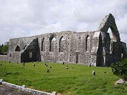 | Castlecarra |
53°43′52″N 9°14′45″W / 53.731016°N 9.245722°W / 53.731016; -9.245722 |
| 222B | Castle Carra | Castle | 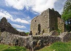 | Castlecarra |
53°43′17″N 9°15′19″W / 53.721465°N 9.255320°W / 53.721465; -9.255320 |
| 432 | Cong Abbey | Priory (Augustinian) | 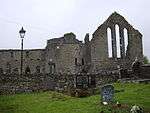 | Cong |
53°32′25″N 9°17′12″W / 53.540255°N 9.286659°W / 53.540255; -9.286659 |
| 308 | Templenagalliaghdoo | Church | | Errew (Tirawley) |
54°03′16″N 9°15′49″W / 54.054387°N 9.263631°W / 54.054387; -9.263631 |
| 307 | Errew Abbey | Priory (Augustinian) | 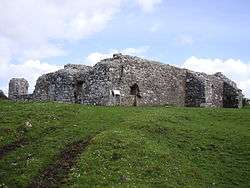 | Errew (Tirawley) |
54°03′11″N 9°15′48″W / 54.053148°N 9.263353°W / 54.053148; -9.263353 |
| 99A | St. Dairbhile's Church | Church | 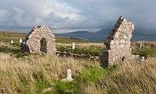 | Fallmore |
54°05′46″N 10°06′25″W / 54.096198°N 10.106976°W / 54.096198; -10.106976 |
| 146 | Glebe Stone Circles | Stone Circles | 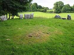 | Glebe (Cong), Nymphstown, Tonaleeaun |
53°32′52″N 9°15′54″W / 53.5477°N 9.2649°W / 53.5477; -9.2649 |
| 198 | Granuaile's Castle | Castle | 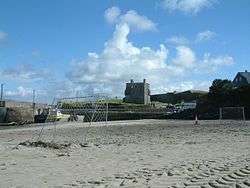 | Glen (Clare Island) |
53°47′59″N 9°57′05″W / 53.799753°N 9.951312°W / 53.799753; -9.951312 |
| 99 | Inishglora | Early Medieval Ecclesiastical Site | 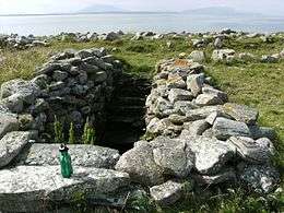 | Inishglora Island |
54°12′31″N 10°07′13″W / 54.208483°N 10.120228°W / 54.208483; -10.120228 |
| 379 | Inishkea North Island | Early Medieval Ecclesiastical Sites | | Inishkea Islands |
54°08′00″N 10°11′16″W / 54.133337°N 10.187876°W / 54.133337; -10.187876 |
| 102 | Inishmaine Abbey | Priory (Augustinian) | 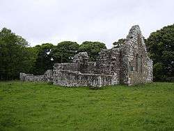 | Inishmaine |
53°35′53″N 9°18′05″W / 53.598077°N 9.301387°W / 53.598077; -9.301387 |
| 619 | Kilcashel Stone Fort | Cashel | 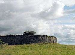 | Kilcashel |
53°53′00″N 8°40′49″W / 53.883436°N 8.680195°W / 53.883436; -8.680195 |
| 402 | Kildermot Church (Killdermot Abbey) | Church | | Kildermot |
54°03′30″N 9°05′25″W / 54.058304°N 9.090279°W / 54.058304; -9.090279 |
| 423 | Kildun Standing Stones | Standing Stones | | Kildun |
53°59′20″N 9°50′24″W / 53.988777°N 9.840015°W / 53.988777; -9.840015 |
| 95A | Kinlough Castle | Castle and church | | Kinlough |
53°29′55″N 9°06′59″W / 53.498557°N 9.116494°W / 53.498557; -9.116494 |
| 296 | Lankill Standing Stone | Standing Stone | | Lankill |
53°45′12″N 9°30′06″W / 53.753238°N 9.501742°W / 53.753238; -9.501742 |
| 98 | Meelick Round Tower | Round Tower | 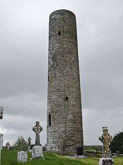 | Meelick |
53°55′17″N 9°01′12″W / 53.921502°N 9.020115°W / 53.921502; -9.020115 |
| 359 | The Gods of the Neale Monument | Monument | | Neale Park |
53°34′26″N 9°13′28″W / 53.57395757°N 9.22446767°W / 53.57395757; -9.22446767 |
| 413 | Kelly's Cave | Cave | | Nymphsfield |
53°32′40″N 9°16′45″W / 53.544443°N 9.279192°W / 53.544443; -9.279192 |
| 664 | Bunnadober Mill | Mill Complex | 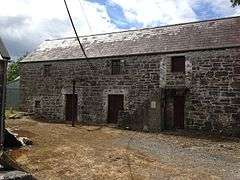 | Rahard (Ballinrobe) |
53°36′27″N 9°16′04″W / 53.607455°N 9.267683°W / 53.607455; -9.267683 |
| 269 | Rathfran Friary | Friary (Dominican) | 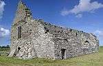 | Rathfran |
54°14′17″N 9°14′40″W / 54.238015°N 9.244375°W / 54.238015; -9.244375 |
| 389 | Rathfran Stone Circle | Stone circle, mound, ringfort, souterrain & enclosure | | Rathfran |
54°14′38″N 9°14′24″W / 54.243797°N 9.240098°W / 54.243797; -9.240098 |
| 633 | Rathfranpark Wedge Tomb | Wedge Tomb | 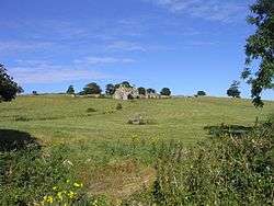 | Rathfranpark |
54°14′31″N 9°15′09″W / 54.241994°N 9.252605°W / 54.241994; -9.252605 |
| 454 | Rockfleet Castle | Castle | _Castle_County_Mayo.JPG) | Newport |
53°53′45″N 9°37′39″W / 53.895949°N 9.627395°W / 53.895949; -9.627395 |
| 386 | Rosdoagh Stone Circle | Stone Circle | | Rosdoagh |
54°16′48″N 9°48′05″W / 54.280107°N 9.801402°W / 54.280107; -9.801402 |
| 104 | Rosserk Abbey | Friary (Franciscan) | 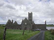 | Rosserk |
54°10′17″N 9°08′36″W / 54.171418°N 9.143457°W / 54.171418; -9.143457 |
| 95 | Shrule Abbey | Church | 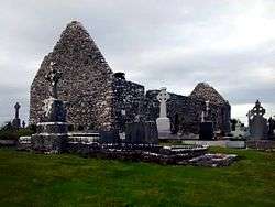 | Shrule |
53°31′08″N 9°05′27″W / 53.518869°N 9.090717°W / 53.518869; -9.090717 |
| 172 | Strade Abbey | Friary (Dominican) | 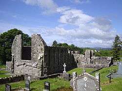 | Strade |
53°55′17″N 9°07′44″W / 53.921527°N 9.128871°W / 53.921527; -9.128871 |
| 97 | Clare Island Abbey | Church (Cistercian) | 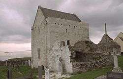 | Lecarrow (Clare Island) |
53°47′36″N 9°59′21″W / 53.793229°N 9.989088°W / 53.793229; -9.989088 |
| 105 | Killala Round Tower | Round Tower | 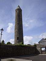 | Killala |
54°12′47″N 9°13′15″W / 54.213066°N 9.220819°W / 54.213066; -9.220819 |
| 100 | Turlough Church | Church & Round Tower | 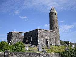 | Turlough |
53°53′19″N 9°12′30″W / 53.888713°N 9.20843°W / 53.888713; -9.20843 |
| | Rathlackan Court Tomb | Court Tomb | 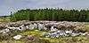 | Lacken, County Mayo |
54°17′27″N 9°16′54″W / 54.290776°N 9.281536°W / 54.290776; -9.281536 |