| NM# |
Monument name |
Description |
Image |
Townland |
Location
|
|---|
| 378 | Lackeen Castle | Castle |  | Abbeville |
53°05′18″N 8°04′26″W / 53.0884°N 8.0738°W / 53.0884; -8.0738 |
| 124 | Ahenny High Crosses | High Crosses | 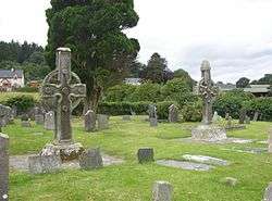 | Ahenny |
52°24′45″N 7°23′41″W / 52.412577°N 7.394614°W / 52.412577; -7.394614 |
| 396 | St. Berrihert's Kyle | Crosses & Inscribed Slabs |  | Ardane |
52°24′39″N 8°05′34″W / 52.410727°N 8.092677°W / 52.410727; -8.092677 |
| 604 | Ardcroney Burial Mound | Burial Mound (Cist) | | Ardcroney |
52°56′28″N 8°11′09″W / 52.941172°N 8.18571°W / 52.941172; -8.18571 |
| 573 | Ashleypark Burial Mound | Burial Moundy (Cist) | | Ashleypark |
52°56′02″N 8°11′20″W / 52.933858°N 8.188848°W / 52.933858; -8.188848 |
| 120 | Athassel Abbey | Priory (Augustinian) |  | Cashel |
52°28′46″N 7°59′01″W / 52.479444°N 7.983611°W / 52.479444; -7.983611 |
| 581 | Ballycomisk | Three Ringforts | | Ballycomisk |
52°29′22″N 7°50′27″W / 52.489523°N 7.840805°W / 52.489523; -7.840805 |
| 659 | Ballingarry Warhouse | House with historical associations | 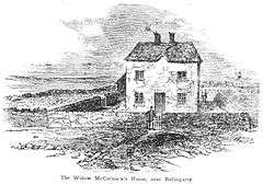 | Farranrory Upper |
52°37′09″N 7°31′22″W / 52.619273°N 7.522898°W / 52.619273; -7.522898 |
| 234 | Ballynahow Castle | Castle | 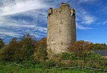 | Ballynahow |
52°41′35″N 7°52′41″W / 52.693070°N 7.878118°W / 52.693070; -7.878118 |
| 123 | Ballynoran Church | Church | | Ballynoran |
52°19′36″N 8°05′16″W / 52.326606°N 8.087783°W / 52.326606; -8.087783 |
| 370 | Burncourt Castle | Castle or fortified house | _-_geograph.org.uk_-_1393348.jpg) | Burncourt |
52°18′53″N 8°04′12″W / 52.314828°N 8.069973°W / 52.314828; -8.069973 |
| 595 | Cahir Abbey (Priory of St. Mary in Cahir) | Priory (Augustinian) | 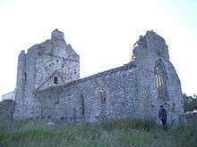 | Cahir |
52°22′45″N 7°55′43″W / 52.379263°N 7.928563°W / 52.379263; -7.928563 |
| 507 | Cahir Castle | Castle | 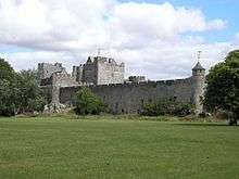 | Cahir |
52°22′28″N 7°55′38″W / 52.374571°N 7.927254°W / 52.374571; -7.927254 |
| 577 | Cahir Castle Cottage | Cahir Castle Cottage | | Cahir |
52°22′26″N 7°55′38″W / 52.374018°N 7.927183°W / 52.374018; -7.927183 |
| 647 | Swiss Cottage | Cottage | 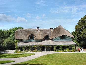 | Cahir |
52°21′27″N 7°55′25″W / 52.357395°N 7.923524°W / 52.357395; -7.923524 |
| 447 | Carrick-on-Suir Castle | Castle | 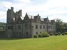 | Carrick-on-Suir |
52°20′42″N 7°24′25″W / 52.345084°N 7.406971°W / 52.345084; -7.406971 |
| 537 | Rathanadav | Ringfort | | Carron (St. Johnbaptist) |
52°28′32″N 7°53′16″W / 52.475425°N 7.887863°W / 52.475425; -7.887863 |
| 550 | Carron fort | Ringfort | | Carron (Tipperary town) |
52°29′37″N 8°10′48″W / 52.493514°N 8.179885°W / 52.493514; -8.179885 |
| 127 | Hore Abbey | Abbey (Cistercian) |  | Cashel |
52°31′07″N 7°53′52″W / 52.5186°N 7.897893°W / 52.5186; -7.897893 |
| 128 | Rock of Cashel | Ecclesiastical site | 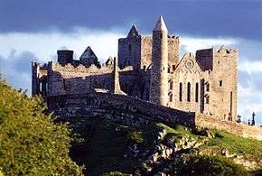 | Cashel |
52°31′12″N 7°53′25″W / 52.51995°N 7.890288°W / 52.51995; -7.890288 |
| 667 | Clonmel Main Guard | Courthouse | %2C_The_Main_Guard_-_geograph.org.uk_-_260570.jpg) | Clonmel |
52°21′10″N 7°41′54″W / 52.352879°N 7.698455°W / 52.352879; -7.698455 |
| 353 | Timoney Hills | Standing Stones | | Cullaun, Timenyhills, Timoney |
52°54′01″N 7°43′12″W / 52.900309°N 7.720127°W / 52.900309; -7.720127 |
| 533 | Derryvella | Early Medieval Ecclesiastical Site | | Derryvella |
52°37′05″N 7°40′09″W / 52.617944°N 7.669056°W / 52.617944; -7.669056 |
| 193 | St. Dominic's Abbey | Abbey (Dominican) |  | Cashel |
52°31′10″N 7°53′13″W / 52.519449°N 7.886933°W / 52.519449; -7.886933 |
| 122 | Donaghmore Church | Church |  | Donaghmore |
52°24′47″N 7°43′29″W / 52.412987°N 7.724840°W / 52.412987; -7.724840 |
| 407 | Grallagh Castle | Castle & Bawn |  | Grallagh |
52°35′41″N 7°46′16″W / 52.594772°N 7.771243°W / 52.594772; -7.771243 |
| 121 | Holy Cross Abbey | Abbey (Cistercian) (part of) | 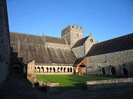 | Holycross |
52°38′25″N 7°52′11″W / 52.640342°N 7.869773°W / 52.640342; -7.869773 |
| 654 | Kilcash Church | Church & graveyard |  | Kilcash |
52°23′50″N 7°31′24″W / 52.397176°N 7.523361°W / 52.397176; -7.523361 |
| 654 | Kilcash Castle | Castle | 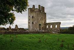 | Kilcash |
52°23′50″N 7°31′16″W / 52.397326°N 7.521244°W / 52.397326; -7.521244 |
| 218 | Kilcooly Abbey | Abbey (Cistercian) | 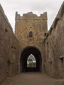 | Kilcoolyabbey |
52°40′15″N 7°34′16″W / 52.670731°N 7.571237°W / 52.670731; -7.571237 |
| 584 | Knockgraffon | Motte & Bailey | 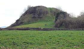 | New Inn |
52°24′44″N 7°55′59″W / 52.412111°N 7.933144°W / 52.412111; -7.933144 |
| 266 | Liathmore | Two Churches |  | Leigh |
52°40′14″N 7°40′07″W / 52.670486°N 7.66858°W / 52.670486; -7.66858 |
| 348 | Lismacrory Mounds | Mounds | 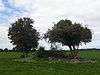 | Lismacrory |
53°02′16″N 8°01′54″W / 53.037717°N 8.031574°W / 53.037717; -8.031574 |
| 524 | Longstone Rath | Standing Stone & prehistoric earthworks | 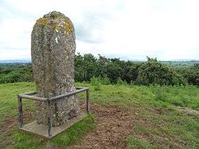 | Longstone |
52°30′22″N 8°17′52″W / 52.506051°N 8.297753°W / 52.506051; -8.297753 |
| 673 | Lorrha Church | Church & two crosses | 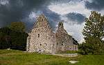 | Lorrha |
53°05′30″N 8°07′13″W / 53.091572°N 8.120249°W / 53.091572; -8.120249 |
| 357 | Lorrha Priory | Priory (Augustinian) | 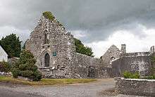 | Lorrha |
53°05′31″N 8°07′17″W / 53.092012°N 8.121414°W / 53.092012; -8.121414 |
| 361 | Lorrha Friary | Friary (Dominican) | 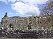 | Lorrha |
53°05′28″N 8°07′34″W / 53.091081°N 8.126113°W / 53.091081; -8.126113 |
| 335 | Derrynaflan Church | Church & Early Medieval Ecclesiastical site | | Lurgoe |
52°35′50″N 7°44′02″W / 52.597315°N 7.733829°W / 52.597315; -7.733829 |
| 125 | Monaincha Church | Church & Cross | 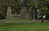 | Monaincha |
52°56′47″N 7°44′53″W / 52.946321°N 7.74795°W / 52.946321; -7.74795 |
| 292 | Moor Abbey | Friary (Franciscan) | 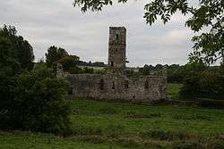 | Moorabbey |
52°24′09″N 8°16′42″W / 52.402466°N 8.278207°W / 52.402466; -8.278207 |
| 513 | Nenagh Castle | Castle |  | Nenagh |
52°51′54″N 8°11′53″W / 52.865014°N 8.198154°W / 52.865014; -8.198154 |
| | Roscrea Friary | Friary (Franciscan) | 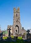 | Roscrea |
52°57′09″N 7°47′59″W / 52.952579°N 7.799620°W / 52.952579; -7.799620 |
| 451 | Portland Church | Church | | Portland |
53°05′24″N 8°10′32″W / 53.090070°N 8.175483°W / 53.090070; -8.175483 |
| 126 | Roscrea Church | Church, Round Tower, High Cross & Mill | 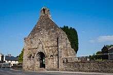 | Roscrea |
52°57′20″N 7°47′45″W / 52.955606°N 7.795717°W / 52.955606; -7.795717 |
| 211 | Roscrea Castle | Castle | 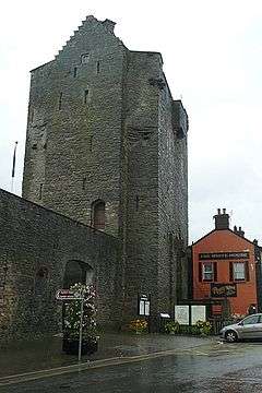 | Roscrea |
52°57′19″N 7°47′53″W / 52.9553°N 7.7980°W / 52.9553; -7.7980 |
| 548 | Shrough Passage Tomb | Passage Tomb | | Shrough |
52°25′37″N 8°13′58″W / 52.426943°N 8.232823°W / 52.426943; -8.232823 |
| 363 | Terryglass Castle | Castle | 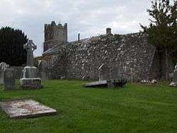 | Terryglass |
53°03′34″N 8°12′43″W / 53.059364°N 8.211910°W / 53.059364; -8.211910 |
| 332 | Toureen Peakaun | Church, Crosses & Slabs | | Toureen |
52°24′32″N 7°59′36″W / 52.408754°N 7.993235°W / 52.408754; -7.993235 |