National Register of Historic Places listings in Peekskill, New York
This is a list of the National Register of Historic Places entries in Peekskill, New York. See also National Register of Historic Places listings in Westchester County, New York for all others in the county.
This is intended to be a complete list of properties and districts listed on the National Register of Historic Places in Peekskill, New York. The locations of National Register properties and districts (at least for all showing latitude and longitude coordinates below) may be seen in a Google map by clicking on "Map of all coordinates".[1]
- This National Park Service list is complete through NPS recent listings posted December 16, 2016.[2]
| Albany (Albany) – Allegany – Bronx – Broome – Cattaraugus – Cayuga – Chautauqua – Chemung – Chenango – Clinton – Columbia – Cortland – Delaware – Dutchess (Poughkeepsie, Rhinebeck) – Erie (Buffalo) – Essex – Franklin – Fulton – Genesee – Greene – Hamilton – Herkimer – Jefferson – Kings – Lewis – Livingston – Madison – Monroe (Rochester) – Montgomery – Nassau – New York (Below 14th Street, 14th to 59th Streets, 59th to 110th Streets, Above 110th Street, Islands) – Niagara – Oneida – Onondaga (Syracuse) – Ontario – Orange – Orleans – Oswego – Otsego – Putnam – Queens – Rensselaer – Richmond – Rockland – St. Lawrence – Saratoga – Schenectady – Schoharie – Schuyler – Seneca – Steuben – Suffolk – Sullivan – Tioga – Tompkins – Ulster – Warren – Washington – Wayne – Westchester (Northern, Southern, New Rochelle, Peekskill, Yonkers) – Wyoming – Yates |
Current listings
| [3] | Name on the Register | Image | Date listed[4] | Location | City or town | Description |
|---|---|---|---|---|---|---|
| 1 | Beecher-McFadden Estate | Upload image | (#87001894) |
E. Main St. 41°17′54″N 73°53′44″W / 41.298333°N 73.895556°W |
Peekskill | |
| 2 | Drum Hill High School | Upload image | (#79003797) |
Ringgold St. 41°17′17″N 73°55′25″W / 41.288056°N 73.923611°W |
Peekskill | |
| 3 | Ford Administration Building | 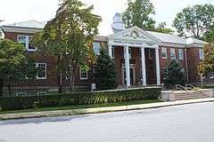 |
(#06000258) |
1031 Elm St. 41°17′17″N 73°55′01″W / 41.288056°N 73.916944°W |
Peekskill | Now the Peekskill City School District Administration Building |
| 4 | Nelson Avenue-Fort Hill Historic District | 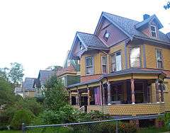 |
(#06000335) |
Roughly along Nelson Ave., John St., Diven St., Constant St., Orchard St., Pauling St., and Decatur Ave. 41°17′48″N 73°55′19″W / 41.296667°N 73.921944°W |
Peekskill | 19th-century residential area with many late Victorian houses |
| 5 | Thomas Nelson House | Upload image | (#01000846) |
1231 Seymour Ln. 41°17′48″N 73°54′49″W / 41.296667°N 73.913611°W |
Peekskill | |
| 6 | Peekskill Downtown Historic District |  |
(#04000095) |
Main, Division, South, Park, Bank, Brown, First and Esther Sts., Central and Union Aves. 41°17′26″N 73°55′12″W / 41.290556°N 73.92°W |
Peekskill | Core of 19th-century Peekskill with landmark Moorish Revival tower at Division and South streets. |
| 7 | Peekskill Freight Depot | |
(#04001207) |
41 S. Water St. 41°17′23″N 73°55′48″W / 41.289722°N 73.93°W |
Peekskill | Abraham Lincoln stopped here on the way to his inauguration and gave a short speech attended by 3,000 people, more than twice the population of Peekskill at the time. It was only appearance ever in Westchester County. Current building is only intact freight depot along former Hudson River Railroad. |
| 8 | Peekskill Presbyterian Church | 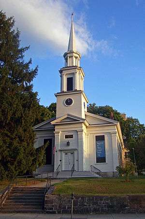 |
(#02001400) |
705 South St. 41°17′19″N 73°55′27″W / 41.288611°N 73.924167°W |
Peekskill | 1846 church has had same bell since congregation was founded in 1790s. |
| 9 | St. Peter's Episcopal Church | 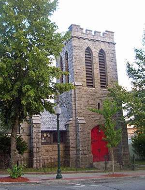 |
(#03000598) |
137 N. Division St. 41°17′33″N 73°55′10″W / 41.2925°N 73.919444°W |
Peekskill | 1892 neo-Gothic church by Richard M. Upjohn |
| 10 | Standard House | 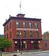 |
(#00001158) |
50 Hudson Ave. 41°17′09″N 73°55′49″W / 41.285833°N 73.930278°W |
Peekskill | 1855 Italianate commercial building, recently restored, is one of only two hotels remaining from industrial era. Now home to its economic-development department |
| 11 | US Post Office-Peekskill | 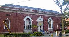 |
(#88002401) |
738 South St. 41°17′22″N 73°55′24″W / 41.289444°N 73.923333°W |
Peekskill | Palladian windows not often found on pre-New Deal Colonial Revival post offices |
| 12 | Van Cortlandt Upper Manor House | 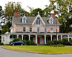 |
(#81000417) |
Oregon Rd. 41°18′44″N 73°54′22″W / 41.312222°N 73.906111°W |
Peekskill | |
| 13 | Villa Loretto | Upload image | (#88000148) |
Crompond Rd. 41°17′25″N 73°54′13″W / 41.290278°N 73.903611°W |
Peekskill |
See also
| Wikimedia Commons has media related to National Register of Historic Places in Peekskill, New York. |
- National Register of Historic Places listings in New York
- National Register of Historic Places listings in Westchester County, New York
- National Register of Historic Places listings in northern Westchester County, New York
References
- ↑ The latitude and longitude information provided in this table was derived originally from the National Register Information System, which has been found to be fairly accurate for about 99% of listings. For about 1% of NRIS original coordinates, experience has shown that one or both coordinates are typos or otherwise extremely far off; some corrections may have been made. A more subtle problem causes many locations to be off by up to 150 yards, depending on location in the country: most NRIS coordinates were derived from tracing out latitude and longitudes off of USGS topographical quadrant maps created under the North American Datum of 1927, which differs from the current, highly accurate WGS84 GPS system used by most on-line maps. Chicago is about right, but NRIS longitudes in Washington are higher by about 4.5 seconds, and are lower by about 2.0 seconds in Maine. Latitudes differ by about 1.0 second in Florida. Some locations in this table may have been corrected to current GPS standards.
- ↑ "National Register of Historic Places: Weekly List Actions". National Park Service, United States Department of the Interior. Retrieved on December 16, 2016.
- ↑ Numbers represent an ordering by significant words. Various colorings, defined here, differentiate National Historic Landmarks and historic districts from other NRHP buildings, structures, sites or objects.
- ↑ The eight-digit number below each date is the number assigned to each location in the National Register Information System database, which can be viewed by clicking the number.
| Topics |   | |
|---|---|---|
| Lists by county |
| |
| Lists by city | ||
| Other lists | ||
| ||
This article is issued from Wikipedia - version of the 10/26/2016. The text is available under the Creative Commons Attribution/Share Alike but additional terms may apply for the media files.